Spook crater is a small crater in the Descartes Highlands of the Moon visited by the astronauts of Apollo 16. The name of the crater was formally adopted by the IAU in 1973.[1] Geology Station 2 is adjacent to Spook, between it and the smaller, younger crater called Buster to the north of it.
 Apollo 16 image, with Flag left of center and Spook right of center. Buster is the small crater north of Spook. | |
| Coordinates | 8°59′S 15°29′E / 8.98°S 15.48°E |
|---|---|
| Diameter | 340 m[1] |
| Eponym | Astronaut-named feature |
On April 21, 1972, the Apollo 16 Lunar Module Orion landed about 500 m east of Spook, which is between the prominent North Ray and South Ray craters. The astronauts John Young and Charles Duke explored the area over the course of three EVAs using a Lunar Roving Vehicle, or rover. They stopped at Spook during EVA 1, on the way back to the LM from Flag crater.
Spook crater is approximately 340 m in diameter and over 20 m deep.[2] Spook is about 550 m west of the landing site itself. The small, fresh crater called Buster is north of Spook. Many samples were collected at the south rim of Buster.
The Lunar Portable Magnetometer (LPM) was used to obtain a reading of approximately 180 γ (gamma) at Spook.[3] This was one of five locations at the landing site where the LPM was used.
Spook cuts into the Cayley Formation of Imbrian age.[4]
-
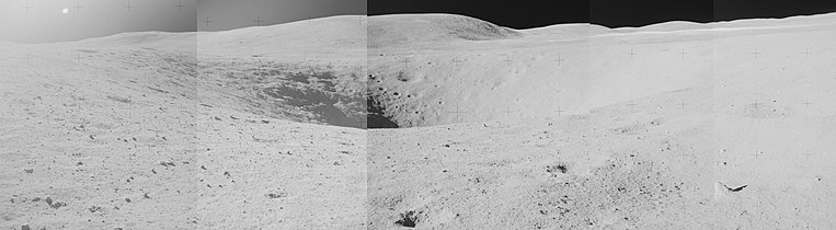 Mosaic showing Spook crater with Stone Mountain in the background. The white line near the horizon at right is the ejecta blanket of South Ray crater.
 -
 The Lunar Portable Magnetometer (LPM) was used to take a magnetic field measurement at the north rim of Spook


Samples edit


The following samples were collected from the vicinity of Buster crater (Station 2), as listed in Table 6-II of the Apollo 16 Preliminary Science Report,[3] which does not include samples smaller than 25 g weight (of which there were many). Sample type, lithology, and descriptions are from the Lunar Sample Atlas of the Lunar and Planetary Institute.[5]
| Sample | Sample Type | Lithology | In-situ Photo | Photo | Description |
|---|---|---|---|---|---|
| 62235 | rake | breccia | .jpg) |
 |
apparently homogeneous, coherent, hollocrystaline impact melt rock with classic poikilitic texture highly enriched in trace elements and siderophile elements and has been dated at 3.88 b.y., with an exposure history of 153 m.y. |
| 62236 | rake | rock | |
 |
found to be a slowly-cooled plutonic rock (Takeda et al. 1979) with an age of ~4.3 b.y. (Borg et al. 1999). |
| 62237 | rock | anorthite | |
 |
chalky white rock |
| 62255 | rock | breccia | .jpg) |
 |
has been crushed and granulated by shock and is penetrated with patches and veins of mafic melt |
| 62275 | rock | anorthite | .jpg) |
very friable, chalky white rock that broke up into powder during handling in curatorial labs and has not been adequately studied. | |
| 62295 | rake | impact melt breccia | .jpg) |
blocky coherent impact melt rock with numerous micrometeorite pits on one side and none on the other |
External links edit
- Apollo 16 Traverses, NASA Lunar Photomap 78D2S2(25)
References edit
- ^ a b Spook, Gazetteer of Planetary Nomenclature, International Astronomical Union (IAU) Working Group for Planetary System Nomenclature (WGPSN)
- ^ Apollo 16 Landing Area, 78D2S1(50), NASA Lunar Topophotomap. Published by The Defense Mapping Agency, November 1974. Available from Lunar and Planetary Institute.
- ^ a b Apollo 16 Preliminary Science Report (NASA SP-315), 1972
- ^ Geologic Map of the Apollo 16 (Descartes) Landing Area by Apollo Field Geology Investigation Team (D. P. Elston, E. L. Boudette, J. P. Schafer), United States Geological Survey, April 1972
- ^ Lunar Sample Atlas, Lunar and Planetary Institute