The soils of the Tanqwa Abergele woreda (district) in Tigray (Ethiopia) reflect its longstanding agricultural history, highly seasonal rainfall regime, relatively high temperatures, overall dominance of Precambrian metamorphic rocks and steep slopes.[1][2]

Factors contributing to soil diversity edit
Climate edit
Annual rainfall depth is very variable with an average of around 600–800 mm.[3] Most rains fall during the main rainy season, which typically extends from June to September. Mean temperature in woreda town Yechila is 25.4 °C, oscillating between average daily minimum of 14.6 °C and maximum of 35.6 °C. The contrasts between day and night air temperatures are much larger than seasonal contrasts.[4]
Geology edit

From the higher to the lower locations, the following geological formations are present:[5]
- Adigrat Sandstone
- Edaga Arbi Glacials
- Precambrian metamorphic rocks
- Quaternary alluvium and freshwater tufa[6]
Topography edit
As part of the Ethiopian highlands the land has undergone a rapid tectonic uplift, leading the occurrence of mountain peaks, plateaus, valleys and gorges.
Land use edit

Generally speaking the level lands and intermediate slopes are occupied by cropland, while there is rangeland and shrubs on the steeper slopes. Remnant forests occur around Orthodox Christian churches and a few inaccessible places. A recent trend is the widespread planting of eucalyptus trees.
Environmental changes edit
Soil degradation in this district became important when humans started deforestation almost 5000 years ago.[7][8] Depending on land use history, locations have been exposed in varying degrees to such land degradation.
Geomorphic regions and soil units edit
Given the complex geology and topography of the district, it has been organised into land systems - areas with specific and unique geomorphic and geological characteristics, characterised by a particular soil distribution along the soil catena.[9][10][11] Soil types are classified in line with World Reference Base for Soil Resources and reference made to main characteristics that can be observed in the field.
Adigrat Sandstone cliff and footslope edit
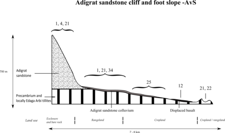


- Associated soil types
- Inclusions
- shallow, dry soils with very high amounts of stones (Leptic and Skeletic Cambisol and Regosol) (4)
- deep, dark cracking clays with good fertility, but problems of waterlogging (Chromic and Pellic Vertisol) (12)
- soils with stagnating water due to an abrupt textural change such as sand over clay (Haplic Planosol]]) (34)
Alluvial plain of Giba River in Abergele edit

- Associated soil types
- deep dark cracking clays with very good natural fertility, waterlogged during the wet season (Chromic Vertisol, Pellic Vertisol) (12)
- brown loamy sands developed on alluvium along Giba River (Fluvisol) (30)
- Inclusion: stony, dark cracking clays with good natural fertility (Vertic Cambisol) (10)
Gallery: soils in Tanqwa Abergele edit
-
 Colluvic Calcic Luvisol profile
 -
 Colluvic Calcic Luvisol in Agbe
 -
 Calcaric Rendzic Leptosol profile
 -
 Calcaric Rendzic Leptosol in Taget
 -
 Pellic Vertisol profile
 -
 Pellic Vertisol in Taget


Catena on metamorphic limestone in Abergele edit


- Associated soil types
- moderately deep, stony, dark cracking clays on calcaric material (Calcaric Vertic Cambisol) (17)
- shallow, stony, dark clay loamy soils (Epileptic Protovertic Cambisol) (18)
- imperfectly to poorly drained, shallow to very shallow, dark soils developed on calcaric material with a moderate natural fertility (Vertic Endoleptic Calcisol) (27)
- Inclusions
- shallow, stony, dark, loamy soils on calcaric material (Rendzic Leptosol) (3)
- shallow, very stony, silt loamy to loamy soils (Skeletic Cambisol, Leptic Cambisol, Skeletic Regosol) (4)
- deep dark cracking clays with very good natural fertility, waterlogged during the wet season (Chromic Vertisol, Pellic Vertisol) (12)
- Brown to dark, silty clay loams to loamy sands developed on alluvium, with good natural fertility (Fluvisol) (30)
Catena on metamorphic sedimentary rock in Abergele edit

- Associated soil types
- Inclusions
Severely incised granite near Giba mouth edit

- Dominant soil type: rock outcrops and very shallow soils (Lithic Leptosol) (1)
- Associated soil type: shallow, very stony, silt loamy to loamy soils (Skeletic Cambisol, Leptic Cambisol, Skeletic Regosol) (4)
Severely incised metamorphic sedimentary rock edit

- Dominant soil type: rock outcrops and very shallow soils (Lithic Leptosol) (1)
- Associated soil type: shallow, stony loam soils (Eutric Regosol and Cambisol) (21)
- Inclusion: clays of floodplains with very high watertable with moderate to good natural fertility (Eutric Gleysol, Gleyic Cambisol) (33)
Metamorphic volcanic rock in Abergele edit

References edit
- ^ Nyssen, Jan; Tielens, Sander; Gebreyohannes, Tesfamichael; Araya, Tigist; Teka, Kassa; Van De Wauw, Johan; Degeyndt, Karen; Descheemaeker, Katrien; Amare, Kassa; Haile, Mitiku; Zenebe, Amanuel; Munro, Neil; Walraevens, Kristine; Gebrehiwot, Kindeya; Poesen, Jean; Frankl, Amaury; Tsegay, Alemtsehay; Deckers, Jozef (2019). "Understanding spatial patterns of soils for sustainable agriculture in northern Ethiopia's tropical mountains". PLOS ONE. 14 (10): e0224041. Bibcode:2019PLoSO..1424041N. doi:10.1371/journal.pone.0224041. PMC 6804989. PMID 31639144.
- ^ Kassa Teka, and colleagues (2015). "Soil, land use and landform relationship in the Precambrian lowlands of northern Ethiopia". Catena. 131: 84–91. doi:10.1016/j.catena.2015.03.010.
- ^ Jacob, M. and colleagues (2013). "Assessing spatio-temporal rainfall variability in a tropical mountain area (Ethiopia) using NOAAs Rainfall Estimates". International Journal of Remote Sensing. 34 (23): 8305–8321. Bibcode:2013IJRS...34.8319J. doi:10.1080/01431161.2013.837230. hdl:1854/LU-4252226. S2CID 140560276.
- ^ Jacob, M. and colleagues (2019). Dogu'a Tembien's Tropical Mountain Climate. In: Geo-trekking in Ethiopia's Tropical Mountains — The Dogu'a Tembien District. SpringerNature. doi:10.1007/978-3-030-04955-3_3. ISBN 978-3-030-04954-6. S2CID 199105560.
- ^ Sembroni, A.; Molin, P.; Dramis, F. (2019). Regional geology of the Dogu'a Tembien massif. In: Geo-trekking in Ethiopia's Tropical Mountains — The Dogu'a Tembien District. SpringerNature. ISBN 978-3-030-04954-6.
- ^ Moeyersons, J. and colleagues (2006). "Age and backfill/overfill stratigraphy of two tufa dams, Tigray Highlands, Ethiopia: Evidence for Late Pleistocene and Holocene wet conditions". Palaeogeography, Palaeoclimatology, Palaeoecology. 230 (1–2): 162–178. Bibcode:2006PPP...230..165M. doi:10.1016/j.palaeo.2005.07.013.
- ^ Nyssen, Jan; Poesen, Jean; Moeyersons, Jan; Deckers, Jozef; Haile, Mitiku; Lang, Andreas (2004). "Human impact on the environment in the Ethiopian and Eritrean highlands - a state of the art". Earth-Science Reviews. 64 (3–4): 273–320. Bibcode:2004ESRv...64..273N. doi:10.1016/S0012-8252(03)00078-3.
- ^ Blond, N. and colleagues (2018). "Terrasses alluviales et terrasses agricoles. Première approche des comblements sédimentaires et de leurs aménagements agricoles depuis 5000 av. n. è. à Wakarida (Éthiopie)" (PDF). Géomorphologie: Relief, Processus, Environnement. 24 (3): 277–300. doi:10.4000/geomorphologie.12258. S2CID 134513245.
- ^ Bui, E.N. (2004). "Soil survey as a knowledge system". Geoderma. 120 (1–2): 17–26. Bibcode:2004Geode.120...17B. doi:10.1016/j.geoderma.2003.07.006.
- ^ "Principes de la cartographie des pédopaysages dans les Alpes". Écologie. 29 (1–2): 49. 1998. ProQuest 223074690.
- ^ Tielens, Sander (2012). Towards a soil map of the Geba catchment using benchmark soils. MSc thesis. Leuven, Belgium: K.U.Leuven.