Sierra Bullones, officially the Municipality of Sierra Bullones (Cebuano: Munisipyo sa Sierra Bullones; Tagalog: Bayan ng Sierra Bullones), is a third class municipality in the province of Bohol, Philippines. According to the 2020 census, it has a population of 26,095 people.[3]
Sierra Bullones | |
|---|---|
| Municipality of Sierra Bullones | |
 Sierra Bullones, Bohol | |
 Flag | |
| Nickname: Golden Town of Bohol | |
 Map of Bohol with Sierra Bullones highlighted | |
OpenStreetMap  | |
.svg) Sierra Bullones Location within the Philippines | |
| Coordinates: 9°49′N 124°17′E / 9.82°N 124.28°E | |
| Country | Philippines |
| Region | Central Visayas |
| Province | Bohol |
| District | 3rd district |
| Founded | 5 January 1863 |
| Barangays | 22 (see Barangays) |
| Government | |
| • Type | Sangguniang Bayan |
| • Mayor | Simplicio C. Maestrado Jr. |
| • Vice Mayor | Rey E. Yamaro |
| • Representative | Kristine Alexie B. Tutor |
| • Municipal Council | Members |
| • Electorate | 17,853 voters (2022) |
| Area | |
| • Total | 198.87 km2 (76.78 sq mi) |
| Elevation | 558 m (1,831 ft) |
| Highest elevation | 874 m (2,867 ft) |
| Lowest elevation | 41 m (135 ft) |
| Population (2020 census)[3] | |
| • Total | 26,095 |
| • Density | 130/km2 (340/sq mi) |
| • Households | 5,892 |
| Economy | |
| • Income class | 3rd municipal income class |
| • Poverty incidence | 27.30 |
| • Revenue | ₱ 139.6 million (2020) |
| • Assets | ₱ 426.1 million (2020) |
| • Expenditure | ₱ 124.2 million (2020) |
| • Liabilities | ₱ 75.34 million (2020) |
| Service provider | |
| • Electricity | Bohol 2 Electric Cooperative (BOHECO 2) |
| Time zone | UTC+8 (PST) |
| ZIP code | 6320 |
| PSGC | |
| IDD : area code | +63 (0)38 |
| Native languages | Boholano dialect Cebuano Eskayan Tagalog |
It is 71 kilometers (44 mi) from Tagbilaran.
The town of Sierra Bullones, Bohol celebrates its fiesta on December 8, to honor the town patron the Immaculate Concepcion.[5]
Etymology edit
The name of town was derived from Spanish words, Sierra which means mountain range and Bulliones, which means bullions (of Gold). During Spanish era, it was said that a number of wealthy Europeans residents buried gold treasures somewhere between the southern barangays of Cantaub and Dusita.[6]
History edit
On January 5, 1863, Sierra Bullones was created a town both in religious and civil aspect, merging the barangays of Pamacsalan, Dinao (Bicao), Panagsagan (Guadalupe), Busoc (Bugsoc), Danicop, and Catagdaan. These villages were carved out from the towns of Candijay, Talibon, Bilar, Jagna, and Batuanan (Alicia). [7]
Initially, the seat of government of the town was at sitio Banlasan of barangay Pamaclasan. Banlasan was later renamed Alegria when it became a separate barrio in 1845.[8] Unfortunately, constant flooding from Wahig River pushed the residents to transfer their town center further south at barangay Candagas and converted it as Poblacion. Alegria on the other hand was later called Lungsod Daan which means old town.[9]
On March 1, 1869, barangays of Dinao (Bicao) and Panagsagan (Guadalupe) together with other barrios from nearby Bilar were carved out from the municipality to create the town of Carmen.[10]
On June 21, 1956, barangays of Caluasan, Candelaria, and San Miguel were re-organized and taken from the municipality with other barriors from Carmen, Trinidad, and Ubay to form the town of Dagohoy, through Executive Order No. 184 issued by President Ramon Magsaysay.[11]
On December 29, 1961, the northern half of the town, consisting of barangays of Aurora, Bagacay, Bagumbayan, Bayong, Buena Suerte, Cagawasan, Catagdaan, Estaca, Ilaud, Lungsod Daan (Poblacion) with sitio Lumbay, Pamacsalan, Rizal (with sitio Del Pilar), and San Carlos carved out from its territories including other barangays from Candijay, Guindulman, and Ubay to form the new municipality of Pilar through the Executive Order No. 460 issued by President Carlos P. Garcia, [12]
Geography edit
Barangays edit
Sierra Bullones is politically subdivided into 22 barangays. Each barangay consists of puroks and some have sitios.
| PSGC | Barangay | Population | ±% p.a. | |||
|---|---|---|---|---|---|---|
| 2020[3] | 2010[13] | |||||
| 071240001 | Abachanan | 7.7% | 2,018 | 1,999 | 0.09% | |
| 071240002 | Anibongan | 2.7% | 698 | 707 | −0.13% | |
| 071240003 | Bugsoc | 9.7% | 2,542 | 2,583 | −0.16% | |
| 071240009 | Cahayag | 1.8% | 479 | 489 | −0.21% | |
| 071240004 | Canlangit | 5.5% | 1,423 | 1,390 | 0.23% | |
| 071240005 | Canta‑ub | 1.4% | 373 | 314 | 1.74% | |
| 071240006 | Casilay | 1.5% | 385 | 407 | −0.55% | |
| 071240007 | Danicop | 3.6% | 946 | 981 | −0.36% | |
| 071240008 | Dusita | 2.4% | 621 | 598 | 0.38% | |
| 071240010 | La Union | 2.5% | 644 | 620 | 0.38% | |
| 071240011 | Lataban | 2.3% | 597 | 512 | 1.55% | |
| 071240012 | Magsaysay | 2.3% | 591 | 580 | 0.19% | |
| 071240013 | Matin‑ao | 5.0% | 1,304 | 1,356 | −0.39% | |
| 071240014 | Nan‑od | 4.3% | 1,134 | 1,072 | 0.56% | |
| 071240015 | Poblacion | 10.7% | 2,782 | 2,763 | 0.07% | |
| 071240016 | Salvador | 6.7% | 1,741 | 1,716 | 0.14% | |
| 071240017 | San Agustin | 4.2% | 1,083 | 1,192 | −0.95% | |
| 071240018 | San Isidro | 5.3% | 1,387 | 1,419 | −0.23% | |
| 071240019 | San Jose | 3.4% | 888 | 879 | 0.10% | |
| 071240020 | San Juan | 3.7% | 960 | 979 | −0.20% | |
| 071240021 | Santa Cruz | 3.5% | 924 | 940 | −0.17% | |
| 071240022 | Villa Garcia | 4.7% | 1,225 | 1,202 | 0.19% | |
| Total | 26,095 | 24,698 | 0.55% | |||
Climate edit
| Climate data for Sierra Bullones, Bohol | |||||||||||||
|---|---|---|---|---|---|---|---|---|---|---|---|---|---|
| Month | Jan | Feb | Mar | Apr | May | Jun | Jul | Aug | Sep | Oct | Nov | Dec | Year |
| Mean daily maximum °C (°F) | 27 (81) |
28 (82) |
29 (84) |
30 (86) |
30 (86) |
29 (84) |
29 (84) |
29 (84) |
29 (84) |
28 (82) |
28 (82) |
28 (82) |
29 (83) |
| Mean daily minimum °C (°F) | 22 (72) |
21 (70) |
22 (72) |
22 (72) |
23 (73) |
24 (75) |
23 (73) |
23 (73) |
23 (73) |
23 (73) |
22 (72) |
22 (72) |
23 (73) |
| Average precipitation mm (inches) | 102 (4.0) |
85 (3.3) |
91 (3.6) |
75 (3.0) |
110 (4.3) |
141 (5.6) |
121 (4.8) |
107 (4.2) |
111 (4.4) |
144 (5.7) |
169 (6.7) |
139 (5.5) |
1,395 (55.1) |
| Average rainy days | 18.6 | 14.8 | 16.5 | 16.7 | 23.9 | 26.4 | 25.6 | 24.1 | 24.4 | 26.3 | 23.7 | 20.5 | 261.5 |
| Source: Meteoblue [14] | |||||||||||||
Demographics edit
| Year | Pop. | ±% p.a. |
|---|---|---|
| 1903 | 2,683 | — |
| 1918 | 6,446 | +6.02% |
| 1939 | 15,964 | +4.41% |
| 1948 | 19,385 | +2.18% |
| 1960 | 19,347 | −0.02% |
| 1970 | 13,807 | −3.31% |
| 1975 | 15,132 | +1.85% |
| 1980 | 17,904 | +3.42% |
| 1990 | 21,101 | +1.66% |
| 1995 | 20,787 | −0.28% |
| 2000 | 25,499 | +4.48% |
| 2007 | 26,398 | +0.48% |
| 2010 | 24,698 | −2.39% |
| 2015 | 24,745 | +0.04% |
| 2020 | 26,095 | +1.05% |
| Source: Philippine Statistics Authority[15][13][16][17] | ||
Economy edit
Graphs are unavailable due to technical issues. There is more info on Phabricator and on MediaWiki.org. |
Gallery edit
-
 Paradise Hills Resort, Sierra Bullones
 -
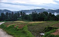 Rice terraces in the hills of Sierra Bullones


References edit
- ^ Municipality of Sierra Bullones | (DILG)
- ^ "2015 Census of Population, Report No. 3 – Population, Land Area, and Population Density" (PDF). Philippine Statistics Authority. Quezon City, Philippines. August 2016. ISSN 0117-1453. Archived (PDF) from the original on May 25, 2021. Retrieved July 16, 2021.
- ^ a b c Census of Population (2020). "Region VII (Central Visayas)". Total Population by Province, City, Municipality and Barangay. Philippine Statistics Authority. Retrieved 8 July 2021.
- ^ "PSA Releases the 2018 Municipal and City Level Poverty Estimates". Philippine Statistics Authority. 15 December 2021. Retrieved 22 January 2022.
- ^ "Sierra Bullones Bohol Travel Guide". www.bohol-philippines.com. Retrieved 2019-02-27.
- ^ "History of Municipality of Sierra Bullones". sierrabullones-bohol.gov.ph. December 31, 2020. Retrieved February 7, 2023.
- ^ "Apendice de los Estados de Poblacion". Guia de Forasteros en Filipinas para el año 1863. Manila: Imprenta de Ramirez y Giraudier. 1863. p. 449.
- ^ "History of barrio Lungsodaan". National Library of the Philippines Digital Collection. 1953. Retrieved February 7, 2023.
- ^ Jes B. Tirol (March 6, 2011). "Toponyms of Bohol and its Towns Part 9". Bohol Chronicle. Archived from the original on April 5, 2011. Retrieved March 12, 2020.
- ^ "Carmen's Colorful Past". bohol-philippines.com. December 31, 2018. Retrieved February 7, 2023.
- ^ Executive Order No. 184 (21 June 1956), CREATING THE MUNICIPALITY OF DAGOHOY IN THE PROVINCE OF BOHOL (PDF)
- ^ Executive Order No. 460 (29 December 1941), Creating the Municipality of Pilar in The Province Of Bohol (1961), Official Gazette (Philippines), retrieved April 7, 2016
- ^ a b Census of Population and Housing (2010). "Region VII (Central Visayas)" (PDF). Total Population by Province, City, Municipality and Barangay. National Statistics Office. Retrieved 29 June 2016.
- ^ "Sierra Bullones: Average Temperatures and Rainfall". Meteoblue. Retrieved 9 May 2020.
- ^ Census of Population (2015). "Region VII (Central Visayas)". Total Population by Province, City, Municipality and Barangay. Philippine Statistics Authority. Retrieved 20 June 2016.
- ^ Censuses of Population (1903–2007). "Region VII (Central Visayas)". Table 1. Population Enumerated in Various Censuses by Province/Highly Urbanized City: 1903 to 2007. National Statistics Office.
{{cite encyclopedia}}: CS1 maint: numeric names: authors list (link) - ^ "Province of Bohol". Municipality Population Data. Local Water Utilities Administration Research Division. Retrieved 17 December 2016.
- ^ "Poverty incidence (PI):". Philippine Statistics Authority. Retrieved December 28, 2020.
- ^ "Estimation of Local Poverty in the Philippines" (PDF). Philippine Statistics Authority. 29 November 2005.
- ^ "2003 City and Municipal Level Poverty Estimates" (PDF). Philippine Statistics Authority. 23 March 2009.
- ^ "City and Municipal Level Poverty Estimates; 2006 and 2009" (PDF). Philippine Statistics Authority. 3 August 2012.
- ^ "2012 Municipal and City Level Poverty Estimates" (PDF). Philippine Statistics Authority. 31 May 2016.
- ^ "Municipal and City Level Small Area Poverty Estimates; 2009, 2012 and 2015". Philippine Statistics Authority. 10 July 2019.
- ^ "PSA Releases the 2018 Municipal and City Level Poverty Estimates". Philippine Statistics Authority. 15 December 2021. Retrieved 22 January 2022.
External links edit
This article about a location in Central Visayas region of the Philippines is a stub. You can help Wikipedia by expanding it. |