Schönefeld (meaning beautiful field) is a suburban municipality in the Dahme-Spreewald district, Brandenburg, Germany. It borders the southeastern districts of Berlin. The municipal area encompasses the old Berlin Schönefeld Airport (SXF) and the new Berlin Brandenburg Airport (BER).
Schönefeld | |
|---|---|
 Schönefeld village church | |
 Coat of arms | |
Location of Schönefeld within Dahme-Spreewald district 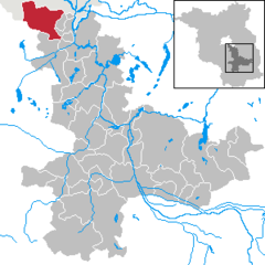 | |
 Schönefeld  Schönefeld | |
| Coordinates: 52°23′18″N 13°30′17″E / 52.38833°N 13.50472°E | |
| Country | Germany |
| State | Brandenburg |
| District | Dahme-Spreewald |
| Subdivisions | 6 Ortsteile |
| Government | |
| • Mayor (2019–27) | Christian Hentschel[1] |
| Area | |
| • Total | 81.57 km2 (31.49 sq mi) |
| Elevation | 44 m (144 ft) |
| Population (2022-12-31)[2] | |
| • Total | 19,174 |
| • Density | 240/km2 (610/sq mi) |
| Time zone | UTC+01:00 (CET) |
| • Summer (DST) | UTC+02:00 (CEST) |
| Postal codes | 12529 |
| Dialling codes | 030, 03379, 033762 |
| Vehicle registration | LDS |
| Website | Official website |
Geography edit
It is located about 22 km (14 mi) southeast of the Berlin city centre, next to Berlin's only airport, Berlin Brandenburg Airport (BER).
In the north, Schönefeld adjoins to the Berlin boroughs of Tempelhof-Schöneberg, Neukölln, and Treptow-Köpenick with the localities of Lichtenrade, Gropiusstadt, Buckow, Rudow, Altglienicke, and Bohnsdorf. In the south, it borders Mittenwalde, in the west, Blankenfelde-Mahlow and in the east, Schulzendorf and Zeuthen.
Civil parishes edit
The Schönefeld municipal area comprises six districts (Ortsteile), former municipalities in their own right which were incorporated in 2003:
- Schönefeld proper
- Großziethen
- Selchow
- Kiekebusch
- Waltersdorf
- Waßmannsdorf
The settlement of Kienberg, part of Waltersdorf, was cleared of residents to permit expansion of the Berlin Brandenburg Airport and is to be developed as a commercial area.
History and monuments edit
The first preserved mention of Schönefeld in the Mittelmark territory dates back to 1242. Sconenfelde, then a possession held by the Lords of Selchow, is documented in the 1375 Landbuch (domesday book) of Emperor Charles IV, when he also ruled as Elector of Brandenburg. The village church, rebuilt in 1904/05 according to plans designed by Franz Heinrich Schwechten, includes a large Baroque altar. Waltersdorf and Waßmannsdorf also have village churches dating to the first half of the 13th century.
From 1933 onwards the Henschel aircraft company moved from Johannisthal Air Field to Schönefeld and had three runways laid out next to the village. More than 14,000 warplanes were built at the site until 1945, when the premises were occupied by the Red Army. In the Großziethen cemetery is a memorial to 200 prisoners of war and forced laborers who died during World War II. The Soviet Air Forces used the air field from 1946, one year later the Soviet Military Administration ordered the buildup of a civil air service supplying East Berlin.
Before German reunification, Schönefeld shared its borders partly with boroughs of former West Berlin (present-day Neukölln and Tempelhof-Schöneberg[3]), and so from 1961 to 1990 it was separated from it by the Berlin Wall.[4][5]
Demography edit
-
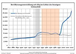 Development of Population since 1875 within the Current Boundaries (Blue Line: Population; Dotted Line: Comparison to Population Development of Brandenburg state; Grey Background: Time of Nazi rule; Red Background: Time of Communist rule)
 -
 Recent Population Development and Projections (Population Development before Census 2011 (blue line); Recent Population Development according to the Census in Germany in 2011 (blue bordered line); Official projections for 2005-2030 (yellow line); for 2020-2030 (green line); for 2017-2030 (scarlet line)


|
|
|
Economy and infrastructure edit
Transport edit
- Berlin Brandenburg Airport
- Schönefeld (bei Berlin) station, opened in 1951 on the Berlin outer ring, is currently served by the Berlin S-Bahn lines S45 and S9
- Berlin Brandenburg Airport railway station beneath the airport Terminal 1 served by S-Bahn, Regional Express "Airport Express" and long distance IC trains, and an S-Bahn station at Waßmannsdorf, between there and the existing Schönefeld station served only by the S-Bahn.
- The Schönefled interchange connects the autobahns A13, A113 with its A117 branch-off, and A10 (Berliner Ring).
- Bundesstraßen B96A and B179
Business edit
The Airport-Center, an industrial area in Waltersdorf, and Berlin Brandenburg Airport are important sources of revenue for Schönefeld.[citation needed]
The head office of Private Wings is located in the General Aviation Terminal (Allgemeine Luftfahrt) on the property of Schönefeld Airport.[7][8][9] Before its disestablishment, the East German airline company Interflug had its head office on the grounds of the airport.[10] Bremenfly also had its head office in Schönefeld.[11]
Politics edit
This section needs to be updated. (June 2021) |

Seats in the municipal council (Gemeinderat):
- Alle für Eine voters' association: 5
- Christian Democratic Union (CDU): 7
- Social Democratic Party of Germany (SPD): 3
- The Left: 2
- Schönefeld citizens' initiative (BIS): 1
- Pro Schönefeld citizens' association: 4
Twin towns — Sister cities edit
Schönefeld is twinned with ![]() Bayangol, a district of Ulaanbataar, since 1999.[12]
Bayangol, a district of Ulaanbataar, since 1999.[12]
Education edit
Primary schools in the municipality:
There is a private secondary school, Evangelische Schule Schönefeld.[15]
Notable people edit
- Rosemarie Clausen, theatrical photographer, born in Großziethen in 1907
- Rudi Dutschke, prominent spokesperson of the German student movement of the 1960s
See also edit
References edit
- ^ Landkreis Dahme-Spreewald Wahl der Bürgermeisterin / des Bürgermeisters, accessed 30 June 2021.
- ^ "Bevölkerungsentwicklung und Bevölkerungsstandim Land Brandenburg Dezember 2022" (PDF). Amt für Statistik Berlin-Brandenburg (in German). June 2023.
- ^ Source: "ADAC StadtAtlas – Berlin-Potsdam". ed. 2007 – pages 232, 233, 234 – ISBN 3-8264-1348-2
- ^ Map and info about the wall on "Berlin Wall Online" (in German)
- ^ Info, maps and pictures (see the sections "Lichterfelde-Schönefeld" and "Schönefeld-East Side Gallery")
- ^ Detailed data sources are to be found in the Wikimedia Commons.Population Projection Brandenburg at Wikimedia Commons
- ^ "Anfahrt GAT Schönefeld." Private Wings. Retrieved on 7 January 2013.
- ^ "Access Business Aviation Center/GAT." Private Wings. Retrieved on 7 January 2013.
- ^ "Imprint." Private Wings. Retrieved on 7 January 2013. "Postal adress: [sic] PRIVATE WINGS Flugcharter GmbH Chief executive officers: Peter Paul Gatz und Andreas Wagner Flughafen Berlin – Schönefeld 12521 Berlin, Germany" and "Delivery address: Private Wings Flugcharter GmbH Waßmannsdorfer Straße 12529 Schönefeld (ehemals Diepensee)"
- ^ "World Airline Directory," Flight International, 26 March 1988, p. 82. (pdf)
- ^ "Kontakt." Bremenfly. 27 August 2010. Retrieved on 7 January 2012. "Zeppelinstr. 1 Berlin-Schönefeld 12529 Deutschland"
- ^ Partnerstadt Bayangol (Twin city Bayangol) on the city's official homepage, accessed 22 July 2014
- ^ "Astrid-Lindgren-Grundschule Schönefeld." Schönefeld. Retrieved on September 13, 2016.
- ^ "Paul-Maar-Grundschule Großziethen." Schönefeld. Retrieved on September 13, 2016.
- ^ "Evangelische Schule Schönefeld – Gymnasium." Schönefeld. Retrieved on September 13, 2016.
Sources edit
- Bernd Kuhlmann. Schönefeld bei Berlin – 1 Amt, 1 Flughafen und 11 Bahnhöfe. Berlin: Gesellschaft für Verkehrspolitik und Eisenbahnwesen, 1996. ISBN 3-89218-038-5 (in German)
External links edit
![]() Media related to Schönefeld at Wikimedia Commons
Media related to Schönefeld at Wikimedia Commons