Piura is a city in northwestern Peru located north of the Sechura Desert on the Piura River. It is the capital of the Piura Region[2] and the Piura Province. Its population was 484,475 as of 2017 and is the 7th most populous city in Peru. The city is located in the central eastern part of the Piura Region, 981 kilometers from the countrys capital, Lima and is near to the border with Ecuador.
Piura
San Miguel de Piura
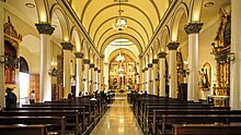
Top:Saint Michael the Archangel Cathedral, Second:Piura University, Piura Miguel Grau Stadium, Third:Piura Almas Square, A street for Hotel Tacna, Bottom:Piura River and Barrio Norte area's panoramic view (all item of left to right)
Flag
Seal
Nickname(s):
La Primera Ciudad (The First City) La Ciudad del Eterno Calor (The City of The Eternal Heat)
It was here that Spanish Conqueror Francisco Pizarro founded the third Spanish city in South America and first in Peru, under the name of San Miguel de Piura, in July[3]: 27 or August[4] of 1532. Piura declared its independence from Spain on 4 January 1821, a few months before Peru gained its independence on 28 July, 1821.[5] It is the commercial and administrative center of the Department of Piura.
Like most of northern Peru, the territory of Piura has been inhabited by their autochthonous group of natives called tallanes and yungas. These groups lived without an organization or single leader to rule until the Muchik culture eventually took control, and the mixture of these evolved into the Vicús culture. The Chimor, Moche and Wari Empire used to occupy the area surrounding the city. Centuries later, Piura came under the rule of Tupac Inca Yupanqui of the Inca Empire for at least 40 years before the Spanish arrived.
Francisco Pizarro came to the area and established it as the third Spanish city in South America, and Spain's first city in Peru.[6]He originally went all the way to what is now Tumbes but decided it was not a suitable base for his operations. With the arrival of the Spanish in 1532, the current mestizo and creole cultures of Piura were born. This mestizo culture includes influences from Spanish Extremadura and Andalucia; African influence, owing to the arrival of slaves from Madagascar (Malgache slaves); Chinesecoolies who migrated from Canton to work the rice fields and replace the slaves; and also Roma Gypsies who came as pirates looking for pearls, or incognito as Spanish horsemen.
The Spanish named the city from the Quechuan word pirhua, meaning "abundance". Nowadays, Piura is known as the "Ciudad del eterno calor" meaning "The city of eternal heat" because it is hot all year round.
In 1820, with the incursions of Admirals Guillermo Brown and Cochrane of the liberating expedition of José de San Martín, the Piuran population enthusiastically joined the liberating cause, and on January 4, 1821, the independence of Piura was proclaimed in the atrium of the temple of San Francisco. The proclamation was an feat led by the heroes José de Lama, Tomás Cortés, Baltazar Taboada, Tomás Diéguez, the Seminario brothers and others. Likewise, the Piura division of 1,000 men contributed victoriously to the independence of Quito, taking part in the Battle of Pichincha, on May 24, 1822.
In 1861, the Department of Piura was created and Piura became the departments capital. The department consisted other three provinces at the time, Piura, Paita and Ayabaca.
In the 1860s, the city of Piura became more dynamic with the cultivation of Pima cotton, brought by Don Emilio Hilbck from the state of Arizona in the United States, which promoted the industrialization and development of the city and the region, and strong immigration. of English, German and Spanish, in that order, and to a lesser extent Italians and Chinese, who brought their customs and also their knowledge of commerce and industry. Many Americans also arrived. They quickly incorporated themselves into the social fabric, forming families with local ladies and inevitably creating new tastes and habits. Even Piura's cuisine was enriched. In agriculture, the use of the steam pump and specialized machinery was introduced, allowing more cropland to be irrigated, expanding the network of canals since the success of Piuran cotton in the international market was a great stimulus for agriculture. New industries appeared such as deep-sea fishing by whaling fleets, mass production and export trade of toquilla straw hats from Catacaos and annexes.
Miguel Grau of Piura
Peruvian war hero of the War of the Pacific against Chile, Miguel Grau Seminario was born in Piura on July 27 1834. He became a hero during the naval Battle of Angamos. According to historians and the Peruvian state, since 2011, they have given the official birthplace of Grau not to Piura but to the port of Paita. Miguel Grau is the most renowned and iconic Peruvian naval officer, being known as el Caballero de los Mares (Spanish for "Gentleman of the Seas").
In the 1980s, Piura and the department again experienced an ascending and thriving commercial, industrial and socioeconomic development, despite having been devastated in the 1983 disaster, as a consequence of the El Niño phenomenon, manifested in torrential rains for six months. that affected its industry, commerce and its urban infrastructure. The El Niño phenomenon that occurred from late 1997 to mid-1998 found the city better prepared, although two of its bridges fell and were subsequently replaced. When it seemed that it was going to be a dry season, in February 2017 it began to rain heavily in what later became known as the coastal Niño phenomenon, and in the early hours of March 27, the river overflowed over the center and northern areas. of the city, causing unforeseen damage, affecting health networks and communication routes.
Piura is experiencing strong development of its commercial sector with the installation of large shopping centers and department stores in no less than five points of the city considered strategic by investors. Furthermore, in recent years the city has expanded considerably with the creation of new developments and human settlements. Likewise, its industrial sector was also developed with the inauguration of the "Piura Futura" industrial estate, northwest of Piura.[7]
Piura Department has a desert and semi-desert climate on the coast and the western slopes of the Andes, whereas on the eastern slopes the climate is subtropical. Precipitation is sparse except during El Niño events, when rainfall is abundant and water flows through normally dry watercourses, causing flooding and large-scale land movements.
The hydrography of Piura Department is determined mainly by the amount of rainfall originating in the Pacific Ocean. This rainfall is itself determined by the meeting of two ocean currents on the southern
coast of the department, around the bay of Sechura: the cold Humboldt current at 13-19 °C, and the warm El Niño at 21-27 °C. These conditions lead to fluctuations in offshore sea temperatures, which are 18-23 °C in winter and spring, and 23-27 °C in summer and sometimes in autumn.
The mean annual humidity is 66%. The mean atmospheric pressure is 1008.5 hPa, while winds are mainly from the north at an average speed of 3 m/s. Annual rainfall varies between 10 and 200 mm at altitudes of 100–500 m; between 200 and 800 mm at altitudes of 500–1500 m; and averages 1,550 mm at altitudes above 1500 m.
Most of the region is arid, with rainfall concentrated in the high Andean areas, while on the wide plains the main water sources are seasonal rivers flowing from the north: the Chira and the Piura. The southern half of the plain consists of the Sechura Desert, which supports herbaceous vegetation.
The main rivers are the Piura, the Huancabamba and the Chira. The reservoir of Poechos has been created within the course of the Chira. It has a capacity of 1,000,000,000 cubic metres and irrigates large portions of the coastal region. The river Quiroz, a tributary of the Piura, supplies the huge artificial lake of San Lorenzo. On the Huancabamba, in the mountains, there is a hydroelectric power station supplying energy to the region.
The Metropolitan area of Piura is made up of the urban centers of the districts of Piura, Veintisirse de Octubre, Castilla and Catacaos, with the city of Piura being the main urban nucleus, in accordance with the "Urban Development Plan of the districts of Piura, Twenty-sixth of October, Castilla and Catacaos in 2032".
The city of Piura has a considerable offer in terms of university vocational training centers; The following universities and a recognized Professional Technical School for business training operate there:
Piura is one of the top tourist destinations in Peru. One of the best-known tourist attractions in Piura is La Esmeralda beach, known as Colan beach for it is located near the town of Colan. It is a very long beach with warm waters. Local people like to go there during holidays.
There are also great spots for surfers, like Playa Cangrejos, Mancora Beach and Cabo Blanco. Cabo Blanco was made famous by visitor Ernest Hemingway in 1956, where he supervised the filming of The Old Man and the Sea.[12]
Piura is host to a stunning mestizo culture (one of the oldest in South America, for Piura is the third Spanish city founded on that continent) most famous for gastronomical dishes like Seco de chabelo, algarrobina-based drinks, many types of seafood and fish, like ceviche and Natilla Sweets. Popular crafts include Chulucana pottery, and Catacaos is famous for its hats and its silversmithing. The small town of Simbila, is very popular for its handcrafts and pottery.
The tondero and cumanana are the traditional music of mestizo Piura and northern parts of Lambayeque. There are also several famous Peruvian Waltz that came from these regions (northern Peruvians have their own style).
The Pan-American Highway goes right through Piura and connects it to other cities in Peru and South America. Mototaxi's are a common form of transportation in the city, offering taxi or business's services. Buses are also common in the city.
A project known as the Tren de la Costa is planned.[citation needed] The project aims to serve all cities along the Peruvian coast from Ica to Sullana. The railway would go through Piura.
^"Klimatafel von Piura, Prov. Piura / Peru"(PDF). Baseline climate means (1961-1990) from stations all over the world (in German). Deutscher Wetterdienst. Retrieved 4 July 2017.


.jpg)


-desde-tribuna-oriente-2018.jpg)


 Empalme, Mexico[citation needed]
 Loja, Ecuador[citation needed]
 Oklahoma City, United States[13]
 Trujillo, Spain[14]
 Piura travel guide from Wikivoyage