St. Paul's is one of eight districts of the island of Saint Helena, part of the British Overseas Territory of Saint Helena, Ascension and Tristan da Cunha in the South Atlantic Ocean. It is the second-most heavily populated district on the island and is located on its northwestern coast.
Saint Paul's | |
|---|---|
 Saint Paul's in Saint Helena | |
| Sovereign state | United Kingdom |
| British overseas territory | |
| Island | Saint Helena |
| Status | District |
| Area | |
| • Total | 4.4 sq mi (11.4 km2) |
| Population (2016) | |
| • Total | 842 (district) |
| • Density | 181/sq mi (69.7/km2) |
| Time zone | UTC+0 (GMT) |
Description edit
Terrain in the district is quite varied, with steep ridges and a limited amount of flat ground, as befits the island's volcanic origin. It is mainly rural and lacks any main settlement, as there are many small villages dispersed throughout.[1] Its population has fluctuated from 795 in 1998 to 908 in 2008[2] and 843 in 2016. It trails only Half Tree Hollow District in size.[3]
The district is named after the Anglican St Paul's Cathedral, which is located there, and also within the district is Plantation House, the Governor's official residence. The island's only secondary school is situated in St Paul's — the Prince Andrew School.[1]
History edit
When the Dutch East India Company occupied St Helena in December 1672, they made their first landing attempt at Lemon Valley Bay, but were beaten off with boulders and rocks thrown by the defenders from the heights on the sides of the valley.[4] After the English recaptured it in May 1673, the mouth of the Lemon Valley was quickly fortified to better deter any future attempts. By 1717 the fort there was ruinous, and a quarantine station was built further up the valley to house the slaves recently received from Madagascar that had smallpox. The fortifications in Lemon Valley were allowed to continue to deteriorate until they were replaced by entirely new buildings 50-odd years later.[5]
-
 Francis Plain
 -
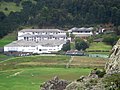 Prince Andrew School
 -

-
 view from Plantation House
 -
 Saint Paul's Cathedral
 -
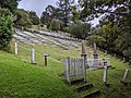 Boer Prisoner of War Cemetery in Knollcombes from below
 -
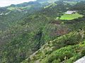
 near Rosemary Plain
 -
 guardhouse at Lemon Valley Bay
 -
 Lemon Valley from the sea
 -
 ruins of the old quarantine station
.jpg)
.jpg)
.jpg)

.jpg)


Notes edit
- ^ a b "St. Paul's". sainthelenaisland.info. Retrieved 27 November 2016.
- ^ "PROVISIONAL RESULTS - POPULATION CENSUS 2008" (PDF). Archived from the original (PDF) on 2014-06-29. Retrieved 25 November 2016.
- ^ "St Helena 2016 Population & Housing: Census Summary Report" (PDF). Census 2016. St Helena Statistics Office. p. 12. Retrieved 21 November 2016.
- ^ "Invasion!: The Only Time St Helena has Been Captured". sainthelenaisland.info. Retrieved 26 November 2016.
- ^ Denholm, p. 29–32
Bibliography edit
- Denholm, Ken. "South Atlantic Fortress" (PDF). Saint Helena Island Info. Retrieved 25 November 2016.