Sárospatak (Hungarian: Sárospataki járás) is a district in north-eastern part of Borsod-Abaúj-Zemplén County. Sárospatak is also the name of the town where the district seat is found. The district is located in the Northern Hungary Statistical Region.
Sárospatak District
Sárospataki járás | |
|---|---|
 Coat of arms | |
 Sárospatak District within Hungary and Borsod-Abaúj-Zemplén County. | |
| Country | |
| County | Borsod-Abaúj-Zemplén |
| District seat | Sárospatak |
| Area | |
| • Total | 477.67 km2 (184.43 sq mi) |
| • Rank | 5th in Borsod-Abaúj-Zemplén |
| Population (2011 census) | |
| • Total | 24,946 |
| • Rank | 8th in Borsod-Abaúj-Zemplén |
| • Density | 52/km2 (130/sq mi) |
Geography edit
Sárospatak District borders with Sátoraljaújhely District to the north, Cigánd District to the east, Ibrány District and Nyíregyháza District (Szabolcs-Szatmár-Bereg County) to the south, Tokaj District and Gönc District to the west. The number of the inhabited places in Sárospatak District is 16.
Municipalities edit
The district has 1 town and 15 villages. (ordered by population, as of 1 January 2012)[1]
- Bodrogolaszi (882)
- Erdőhorváti (545)
- Györgytarló (563)
- Háromhuta (125)
- Hercegkút (624)
- Kenézlő (1,229)
- Komlóska (237)
- Makkoshotyka (869)
- Olaszliszka (1,661)
- Sárazsadány (249)
- Sárospatak (12,590) – district seat
- Tolcsva (1,681)
- Vajdácska (1,302)
- Vámosújfalu (857)
- Viss (631)
- Zalkod (201)
The bolded municipality is the city.
Demographics edit
Religion in Sárospatak District (2011 census)
In 2011, it had a population of 24,946 and the population density was 52/km².
| Year | County population[2] | Change |
|---|---|---|
| 2011 | 24,946 | n/a |
Ethnicity edit
Besides the Hungarian majority, the main minorities are the Roma (approx. 1,500), German (650) and Rusyn (350).
Total population (2011 census): 24,946
Ethnic groups (2011 census):[3] Identified themselves: 23,789 persons:
- Hungarians: 21,009 (88.31%)
- Gypsies: 1,502 (6.31%)
- Germans: 629 (2.64%)
- Rusyns: 359 (1.51%)
- Others and indefinable: 290 (1.22%)
Approx. 1,000 people in Sárospatak District did not declare their ethnic group at the 2011 census.
Religion edit
Religious adherence in the county according to 2011 census:[4]
- Catholic – 11,714 (Roman Catholic – 8,376; Greek Catholic – 3,331);
- Reformed – 5,600;
- Evangelical – 36;
- other religions – 332;
- Non-religious – 1,009;
- Atheism – 100;
- Undeclared – 6,155.
Gallery edit
-

-
 Aerial view of Háromhuta (Óhuta)
 -
 Meczner Mansion in Makkoshotyka
 -
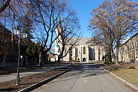 Castle Church in Sárospatak


_-_Makkoshotyka,_2014.06.19_(1).JPG)

See also edit
References edit
- ^ A KSH 2012. évi helységnévkönyve
- ^ népesség.com, "Sárospataki járás népessége"
- ^ 4.1.6.1 A népesség nemzetiség szerint, 2011, (in Hungarian) [1]
- ^ 4.1.7.1 A népesség vallás, felekezet szerint, 2011, (in Hungarian) [2]
External links edit
48°18′00″N 21°31′00″E / 48.3000°N 21.5167°E
This Borsod-Abaúj-Zemplén location article is a stub. You can help Wikipedia by expanding it. |