Rhosddu (Welsh: Rhos-ddu;[2] ⓘ) is a suburb and community in Wrexham County Borough, Wales, covering the north-western parts of the city of Wrexham and comprises the wards of Grosvenor, Garden Village and Stansty.
Rhosddu
| |
|---|---|
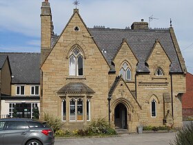
.JPG) St James' church in Rhosddu | |
 Map of the community. | |
 Rhosddu Location within Wrexham | |
| Population | 6,840 (2011 Census)[1] |
| OS grid reference | SJ 33290 51092 |
| Principal area | |
| Preserved county | |
| Country | Wales |
| Sovereign state | United Kingdom |
| Post town | WREXHAM |
| Postcode district | LL11, LL12, LL13 |
| Dialling code | 01978 |
| Police | North Wales |
| Fire | North Wales |
| Ambulance | Welsh |
| UK Parliament | |
| Senedd Cymru – Welsh Parliament | |
At the 2011 Census, the population of the community was 6,840[3] and 11.8% of people aged 3+ spoke Welsh.[4]
Administration edit
Rhosddu was formed as a new ecclesiastical parish by an Order in Council in 1886. The parish contained the townships of Acton, Bieston and Gourton (from the parish of Wrexham), the township of Borras Riffri (from the parish of Gresford), and the township of Stansty (from the parish of Gwersyllt).[5] In 1972, Rhosddu reverted to the parish of Wrexham.
The area of Rhosddu was in the civil parish of Stansty, which was part of the old Wrexham Municipal Borough. The administrative structures of the Municipal Borough were abolished in 1974, under the terms of the Local Government Act 1972. Rhosddu was created as one of the communities of Wrexham Maelor after a 1985 boundary review, which brought four new communities into being within the town of Wrexham itself (Rhosddu, Offa, Caia Park, and Acton).
History edit
The name Rhosddu is formed on the Welsh words rhos, "moor" or "rush pasture", and ddu, "black". The name may derive from the presence of coal and peat below the poorly drained surface as evidenced by old field names in the neighbouring Stansty area which indicate similar features e.g. 'Tirodd Duon' (black lands).[6] It is likely that the area was common land in Medieval times used by tenants of the manor as rough pasture for cattle grazing.[7] Rhosddu Farm (also known as Walnut Tree Farm) was first recorded in 1762 in the possession of the Griffiths family and was located on the site of the Walnut Tree public house on New Road.[8]
The first housing developments in the Rhosddu area began from 1856 following the arrival of the railway and the location of associated goods and carriage sheds in the area.[9] The population increased further as a result of the Wrexham and Action Colliery which opened in the late 1860s.[10]
St James' church was built in Cefn sandstone to designs by W. Turner of Wrexham. The foundation was laid on 30 September 1874 and it was opened for worship in January 1876, although it was not consecrated until 27 April 1886. The church is now a Grade II Listed building, being considered a good example of a late 19th-century church retaining many original features.[11]
Rhosddu School (originally known as Stansty Park Board School) opened in 1877 and moved into its current premises on Price's Lane in 1915.
Grosvenor Road Conservation Area is situated to the north west of the commercial city centre and incorporates Grosvenor Road, Grove Road and parts of Gerald Street, Regent Street, King Street, Grove Park Road, Rhosddu Road and part of the Coleg Cambria Campus.[12]
Dissenters' Burying Ground edit
The Dissenters' Burying Ground on Rhosddu Road was originally a field of about one acre on land given to the Wrexham Nonconformists during the early 1600s by the Puritan Daniel Lloyd of Pen y Bryn Farm. The graveyard was probably laid out during the 1650s during the Interregnum period.[13][14] By the mid-18th century, the graveyard was being used and maintained by the Baptist Church and, in 1788, an ongoing ownership dispute of the Ground was resolved allowing Presbyterians to be buried there upon payment of a fee to the Baptist Church. Hay was grown and sold to pay for a grave digger and other expenses.[15] During the night of the Wrexham races, in the mid-1840s, all but one of the brass memorial plates were stolen from the tombs, thus destroying many family histories.[16] The last burial took place in 1901. When the Ground was closed to new burials in 1888, it contained 27 family vaults, a number of brick graves and 920 private family earthen graves.[17] The graveyard was later landscaped and is now a public park.
Many notable people are buried here including the great Puritan Morgan Llwyd (d.1659) and the ironmaster William Wilkinson (d.1808). Margaret Lloyd George unveiled a memorial to Morgan Llwyd in 1912.[18]
Residents edit
John Godfrey Parry-Thomas, the engineer and motor-racing driver, was the son of the curate of Rhosddu and lived in the area during his childhood.
Sports edit
Wrexham A.F.C. played their home games in the 1881–82 and 1882–83 seasons at Rhosddu Recreation Ground (changing the club's name to Wrexham Athletic for one season), before moving back to the Racecourse Ground for the 1883–84 season, where they have remained.
Gallery edit
-
 Morgan Llwyd Memorial, Dissenters' Burial Ground
 -
-
 The Community Church, Prices Lane (previously 'Price's Lane Ebeneser Welsh Presbyterian Chapel'), built 1873
 -
 Park Lodge, an example of the neo-gothic style prevalent amongst houses along Rhosddu Road
.JPG)
.JPG)
.JPG)

References edit
- ^ "Community population 2011". Retrieved 19 November 2015.
- ^ "Standardised Welsh Place names". www.welshlanguagecommissioner.wales. Retrieved 2023-03-29.
- ^ "Community population 2011". Retrieved 19 November 2015.
- ^ contact-us@wrexham.gov.uk, Wrexham County Borough Council, Guildhall, Wrexham LL11 1AY, UK. "Facts & Statistics: Profiles and Summaries - WCBC". old.wrexham.gov.uk. Retrieved 2020-08-21.
{{cite web}}: CS1 maint: multiple names: authors list (link) CS1 maint: numeric names: authors list (link) - ^ Rhosddu, St James, GENUKI
- ^ Williams, W. Alister. (2001). The encyclopædia of Wrexham. Wrexham: Bridge Books. ISBN 1-872424-66-X. OCLC 49330782.
- ^ A History of Wrexham, Denbighshire. Dodd, A. H. (Arthur Herbert), 1891-1975., Wrexham Maelor (Wales). Borough Council. Wrexham: Published for the Wrexham Borough Council ... [by Bridge Books]. 1989. ISBN 1-872424-01-5. OCLC 59816349.
{{cite book}}: CS1 maint: others (link) - ^ A History of Wrexham, Denbighshire. Dodd, A. H. (Arthur Herbert), 1891-1975., Wrexham Maelor (Wales). Borough Council. Wrexham: Published for the Wrexham Borough Council ... [by Bridge Books]. 1989. ISBN 1-872424-01-5. OCLC 59816349.
{{cite book}}: CS1 maint: others (link) - ^ Williams, W. Alister. (2001). The encyclopædia of Wrexham. Wrexham: Bridge Books. ISBN 1-872424-66-X. OCLC 49330782.
- ^ Williams, W. Alister. (2001). The encyclopædia of Wrexham. Wrexham: Bridge Books. ISBN 1-872424-66-X. OCLC 49330782.
- ^ Church of St James, Rhosddu, Wrexham Archived 2012-03-21 at the Wayback Machine, Wrexham County Borough Council
- ^ contact-us@wrexham.gov.uk, Wrexham County Borough Council, Guildhall, Wrexham LL11 1AY, UK. "Grosvenor Road Conservation Area - WCBC". old.wrexham.gov.uk. Retrieved 2020-08-21.
{{cite web}}: CS1 maint: multiple names: authors list (link) CS1 maint: numeric names: authors list (link) - ^ Williams, W. Alister. (2001). The encyclopædia of Wrexham. Wrexham: Bridge Books. ISBN 1-872424-66-X. OCLC 49330782.
- ^ "Dissenters Burial Ground 1655 – Wrexham History". Retrieved 2020-08-21.
- ^ Palmer, A.N. 1888, A History of the Older Nonconformity of Wrexham and its Neighbourhood, Wrexham: Woodall Mishall and Thomas.
- ^ Palmer 1888,p.164
- ^ Price, G. V. 1951, The dissenters burial ground, Wrexham
- ^ Williams, W. Alister. (2001). The encyclopædia of Wrexham. Wrexham: Bridge Books. ISBN 1-872424-66-X. OCLC 49330782.