Puerto Rico Highway 504 (PR-504) is a tertiary[2] state[3] highway in the municipality of Ponce in Puerto Rico. With a length of 6.9 km (4.3 mi), the road runs south to north, and mostly along the Río Chiquito in barrio Portugués Rural. Its southern terminus is at an intersection with PR-503, near PR-10 at the southern edge of Barrio Portugués, and the northern terminus is located at PR-505 on the Machuelo Arriba–Portugués–Montes Llanos tripoint.
Highway 504 | ||||
|---|---|---|---|---|
| Ruta 504 | ||||
.svg) | ||||
| Route information | ||||
| Maintained by Puerto Rico DTPW | ||||
| Length | 6.9 km[1] (4.3 mi) | |||
| Major junctions | ||||
| South end | ||||
| North end | ||||
| Location | ||||
| Country | United States | |||
| Territory | Puerto Rico | |||
| Municipalities | Ponce | |||
| Highway system | ||||
| ||||

Route description edit
The road is a mountainous two-way one-lane road and thus very difficult to navigate when traffic is coming from the opposite direction. In addition most of the road has numerous steep sharp curves and should be driven only with vehicles in top mechanical condition, preferably all-wheel drive sedans, as drivers of SUVs reportedly feel less in control of their vehicles. The road should not be driven after nightfall.
The road is 6.9 km (4.3 mi) kilometers long. At kilometer mark 3.0 km (1.9 mi), PR-504 connects with PR-588 (also known as Camino Pandora or Camino Río Chiquito) heading west towards Sector El Hoyo. PR-588's northern terminus is at kilometer 7.2 km (4.5 mi) of PR-505 in Barrio Montes Llanos.
-
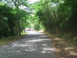 Puerto Rico Highway 504 heading south in Barrio Portugués Rural, Ponce, Puerto Rico
.jpg)
Major intersections edit
The entire route is located in Ponce.
-
 PR-504 heading south near PR-588 intersection in Barrio Portugués Rural
 -
 PR-504 heading north at PR-588 intersection in Barrio Portugués Rural
.jpg)
.jpg)
| Location | km[1] | mi | Destinations | Notes | |
|---|---|---|---|---|---|
| Portugués | 0.0 | 0.0 | Southern terminus of PR-504; partial cloverleaf interchange | ||
| 3.3 | 2.1 | ||||
| Machuelo Arriba–Portugués– Montes Llanos tripoint | 6.9 | 4.3 | Northern terminus of PR-504 | ||
| 1.000 mi = 1.609 km; 1.000 km = 0.621 mi | |||||
See also edit
References edit
- ^ a b Google (1 March 2020). "PR-504" (Map). Google Maps. Google. Retrieved 1 March 2020.
- ^ PRHTA Design Manual: Chapter 1, General Design Criteria. Departamento de Transportación y Obras Publicas de Puerto Rico. page 1-2. Accessed 9 May 2019.
- ^ ¿Una avenida o zona de combate? Primera Hora. 19 June 2014. Retrieved 24 June 2014.
External links edit
This Ponce, Puerto Rico location article is a stub. You can help Wikipedia by expanding it. |
This Puerto Rico road-related article is a stub. You can help Wikipedia by expanding it. |