Odoorn (Dutch pronunciation: [ˈoːdoːr(ə)n]) is a village in the Dutch province of Drenthe. It is a part of the municipality of Borger-Odoorn, and lies about nine km north of Emmen.
Odoorn | |
|---|---|
 The library in 2007 | |
 Odoorn Location in the province of Drenthe in the Netherlands  Odoorn Odoorn (Netherlands) | |
| Coordinates: 52°51′N 6°51′E / 52.850°N 6.850°E | |
| Country | Netherlands |
| Province | Drenthe |
| Municipality | Borger-Odoorn |
| Area | |
| • Total | 13.81 km2 (5.33 sq mi) |
| Elevation | 24 m (79 ft) |
| Population (2021)[1] | |
| • Total | 1,890 |
| • Density | 140/km2 (350/sq mi) |
| Time zone | UTC+1 (CET) |
| • Summer (DST) | UTC+2 (CEST) |
| Postal code | 7873[1] |
| Dialing code | 0591 |
History edit
The village was first mentioned in 1327 as "Remboldus in Oderen". It is assumed it means "settlement of the people of Odheri (person)", because older forms often used the suffix -ing.[3]
Odoorn is an esdorp which developed in the Early Middle Ages on the Hondsrug along the road from Groningen to Coevorden. In the 13th century, a daughter church of Anloo was established in the village, and it developed into the central settlement for the satellites Valthe and Exloo.[4]
The Dutch Reformed church was built around 1200 and is built using many large stones. Some of the stones have probably been taken from nearby hunebedden (dolmen). The church suffered a collapse in 1634. It was extensively modified between 1856 and 1857. In 1897, it was restored after a fire.[4][5]
The hunebed (dolmen) D32 is located near Odoorn. It is still half buried in the ground. It used to have five capstones, however one has gone missing.[6]
Odoorn was home to 348 people in 1840.[5] On 22 July 1945, three children were playing with left-over German ammunition, and they were killed when the ammunition exploded. In 1997, a memorial was placed at the site.[7] Odoorn was a separate municipality until 1998, when it merged with Borger.[8]
Festivals edit
Odoorn hosts the multi-culture festival SIVO International Folkloristic Dans festival.[5]
Gallery edit
-
 Street view
 -
 Village pub
 -
 Hunebed (dolmen) D32
 -
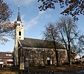 Dutch Reformed church


_dekstenen_die_op_de_grond_liggen.jpg)

References edit
- ^ a b c "Kerncijfers wijken en buurten 2021". Central Bureau of Statistics. Retrieved 11 April 2022.
- ^ "Postcodetool for 7873AA". Actueel Hoogtebestand Nederland (in Dutch). Het Waterschapshuis. Retrieved 11 April 2022.
- ^ "Odoorn - (geografische naam)". Etymologiebank (in Dutch). Retrieved 11 April 2022.
- ^ a b Ronald Stenvert (2001). Odoorn (in Dutch). Zwolle: Waanders. p. 61. ISBN 90 400 9454 3. Retrieved 11 April 2022.
- ^ a b c "Odoorn". Plaatsengids (in Dutch). Retrieved 11 April 2022.
- ^ "D32 - Odoorn". Hunebedden (in Dutch). Retrieved 11 April 2022.
- ^ "Odoorn, monument in de boswachterij Odoorn". 4 en 5 mei (in Dutch). Retrieved 11 April 2022.
- ^ Ad van der Meer and Onno Boonstra, Repertorium van Nederlandse gemeenten, KNAW, 2011.
External links edit
 Media related to Odoorn at Wikimedia Commons