You can help expand this article with text translated from the corresponding article in Vietnamese. (March 2009) Click [show] for important translation instructions.
|
Nam Sách is a rural district of Hải Dương province in the Red River Delta region of Vietnam. As of 2003 the district had a population of 139,184.[1] The district covers an area of 133 km2. The district capital lies at Nam Sách.[1]
Nam Sách District
Huyện Nam Sách | |
|---|---|
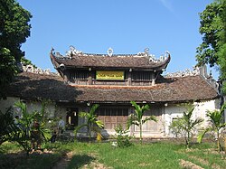
 Hundred Gian Pagoda in An Đông village, An Bình commune, Nam Sách district | |
 | |
| Country | |
| Region | Red River Delta |
| Province | Hải Dương |
| Capital | Nam Sách |
| Area | |
| • Total | 51 sq mi (133 km2) |
| Population (2003) | |
| • Total | 139,184 |
| Time zone | UTC+07:00 (Indochina Time) |
History edit
The area Nam Sách (南策) is the source of many pottery artifacts.[2] In 1592, when what is today Hải Dương province was under Mạc dynasty control, Nam Sách along with Kim Thành, Thanh Hà, and Kinh Môn districts were the target of attack by 300 fighting boats of the Lê dynasty.[3]
Notable people edit
- Pháp Loa, disciple of Trần Nhân Tông[4]
- vi:Phạm Tuấn Tài (1905-1937) a teacher and revolutionary[5]
References edit
- ^ a b "Districts of Vietnam". Statoids. Retrieved March 20, 2009.
- ^ Vietnam Fine Arts Museum Bảo tàng mỹ thuật Việt Nam - 2000 106 "Transcription in QUỐC ngữ ( Vietnamese) Z " Thái Hoà bât niên tượng nhân Nam Sách Châu Bùi Thị hý bút". Rough translation I "In the eighth year of Thái Hoà reign title (1450), the potter surnamed Bùi at Nam Sách district ( Hái Dương ..."
- ^ A Brief Chronology of Vietnam's History Anh Thư Hà, Hồng Đức Trần - 2000 p110 "On November 25, 1592, some 300 fighting boats of the Lê regime attacked Kim Thành, Thanh Hà, Nam Sách and Kinh Môn districts (Hãi Dương province nowadays). The resistance of Mạc troops was broken, and a big portion of the armed ..."
- ^ The Vietnam Forum Yale University - 1985 "Il est né en 1284 à Cub La, village du district Nam Sách qui fait partie de la province Hải Dương. Il sera novice en 1304 sous Trân Nhân Tông et prendra le nom religieux de Thiên Lai. Nhân Tông le confie au maître Tinh Giác de la pagode ..."
- ^ Van Dao Hoang Việt Nam Quốc Dân Đảng: A Contemporary History 2008 p216 Phạm Tuấn Tài was born in Phù Cừ village, Phù Cừ canton, Nam Sách district, Hải Dương Province."