Musselman's Lake is a community settled adjacent to a 118-acre (0.48 km2) kettle lake of the same name in the town of Whitchurch–Stouffville, Ontario, Canada. It is located about 6 km north-northwest of urban Stouffville, and is part of the Greater Toronto Area.
Musselman's Lake
Musselman Lake | |
|---|---|
Unincorporated community | |
.jpg) | |
| Coordinates: 44°1′51″N 79°16′23″W / 44.03083°N 79.27306°W | |
| Country | Canada |
| Province | Ontario |
| Regional municipality | York Region |
| Town | Whitchurch–Stouffville |
| Amalgamation | (With Town of Stouffville) 1 January 1971 |
| Government | |
| • Type | Municipality |
| • Mayor | Iain Lovatt |
| • Councillor | Maurice Smith (Ward 2) |
| Elevation | 334 m (1,096 ft) |
| Time zone | UTC−5 (EST) |
| • Summer (DST) | UTC−4 (EDT) |
| Forward sortation area | |
| Area code(s) | 905 and 289 |
| NTS Map | 031D03 |
| GNBC Code | FDLCI |
It is accessible from Highway 48, which links Toronto to Beaverton, and from Highway 404, a limited-access 400-Series Highway 9 kilometres (5.6 mi) west of Musselman's Lake via Aurora Road or Bloomington Road. Ontario Highway 407 is located about 20 kilometres (12 mi) south on Ninth Line in Markham. The main roads in the community are Ninth Line on the west side of the lake, and Lakeshore Road on the east.[1] The area around the lake is dotted with a number of smaller kettle lakes, including Island Lake, Shadow Lake, Staley Lake and Windsor Lake. The area around Musselman's Lake feeds a small tributary to the East Holland River, which flows to the west.
Environment edit
Musselman's Lake is on the ecologically sensitive Oak Ridges Moraine; the land drains into both the Lake Ontario and Lake Simcoe watersheds. Pine trees dominate much of the area, with farmland toward the north-east. Creeks and streams are also characteristic of the area.
Sand and gravel mining is widespread to the south and east of Musselman's Lake. The mining industry began in the 1950s and continues through the present. Lee Sand & Gravel has been in operations since the 1950s and owned by Crupi Group since 1987. Lafarge has operations next to Lee on the east side along York-Durham Townline.
Residential areas are concentrated around Musselman's Lake and Windsor Lake, and on a few other large lots. The Town of Whitchurch-Stouffville forecasts the population of Musselman's Lake to decline slightly between 2012 and 2031.[2]
The lake has a surface area of 118-acre (0.48 km2), with a maximum depth of approximately 27-foot (8.2 m). It is landlocked and fed by springs and surface runoff.[3]
In 2009, the Musselman's Lake Subwatershed Assessment and Stewardship Opportunities Report recognized that the water quality of the lake was "impaired" and "degraded," and had declined since 1989 when a similar study had been done.[4]
A variety of fish[5] have been found in the lake including:
History edit
The area was first settled 1807 by Peter and Jacob Musselman (not related to settler of Floradale, Ontario), who were Mennonites from Pennsylvania.[6] The Musselman established as steam saw mill on the west side of the lake on land later acquired by William Osborn.[7]
The Glen Baker Hotel and Hall provided local entertainment until 1928 and again until 1970s.[8]
In the 1950s and 1960s housing developments were built around Musselman's Lake.[citation needed]
Over the years, the community has been referred to both as Musselman's Lake and as Musselman Lake. In 2012, the Town of Whitchurch-Stouffville officially declared the name of the community as "Musselman's Lake."[9]
On June 17, 2017, the five acre Coultice Park was officially opened on land which was formerly a part of the Wagon Wheel Ranch and donated to the Town by the Coultice family.[10]
Privately owned waterfront edit
Virtually all of the water front in the community of Musselman's Lake is private residential property. Cedar Beach Park is a small park and beach on the northside at Cedarvale Boulevard and Ninth Line is privately run and require admission. Docks along the lake are all private with Cedar Beach Park open to the paying public but not for daily visitors.
Use of the lake and its shorelines is regulated by the Department of Fisheries and Oceans Canada in conjunction with the Lake Simcoe Region Conservation Authority; the Ministry of Natural Resources governs fishing regulations, town by-laws regulate the use of power boats on the lake, and laws are enforced by the York Regional Police Marine Unit. While the resources of all levels of government are used for the regulation, protection and preservation of the lake, the entire perimeter of the lake is currently in a few private hands, and homeowners and business alone benefit from exclusive access rights to one of Whitchurch-Stouffville's most significant natural and recreational assets.
Nearest communities edit
Musselman's Lake is situated near the eastern boundary of the town of Whitchurch–Stouffville. Neighbouring communities within Whitchurch–Stouffville include Ballantrae to the north-east and Bloomington to the south. Goodwood, a community of the town of Uxbridge, lies to the east.
Campgrounds edit
Two private campgrounds are located north of the lake:
- Cedar Beach Trailer Park - operates Cedar Beach Park
- Shadow Lake Campgrounds - (former McKewon Lake on the land owned by Robert McKewon) frequently used by Scouts Canada troops
References edit
- ^ Town of Whitchurch-Stouffville, Ballantrae-Musselman Lake and Environs Secondary Plan, 2014.
- ^ Town of Whitchurh-Stouffville, "Growth Management Strategy: Alternative Growth Options Discussion Paper Archived 2013-10-29 at the Wayback Machine" (March 15, 2013), 3-2, Fig. 13.
- ^ Ontario Ministry of the Environment, Report on a Water Quality Survey Musselman Lake, Town of Whitchurch-Stouffville, 1972, p. 1.
- ^ Cf. Lake Simcoe Conservation Authority and the Town of Whitchurch-Stouffville, "Musselman's Lake Subwatershed Assessment and Stewardship Opportunities Report Archived 2010-09-27 at the Wayback Machine," March 31, 2009.
- ^ "Variety of fish pulled from lake".
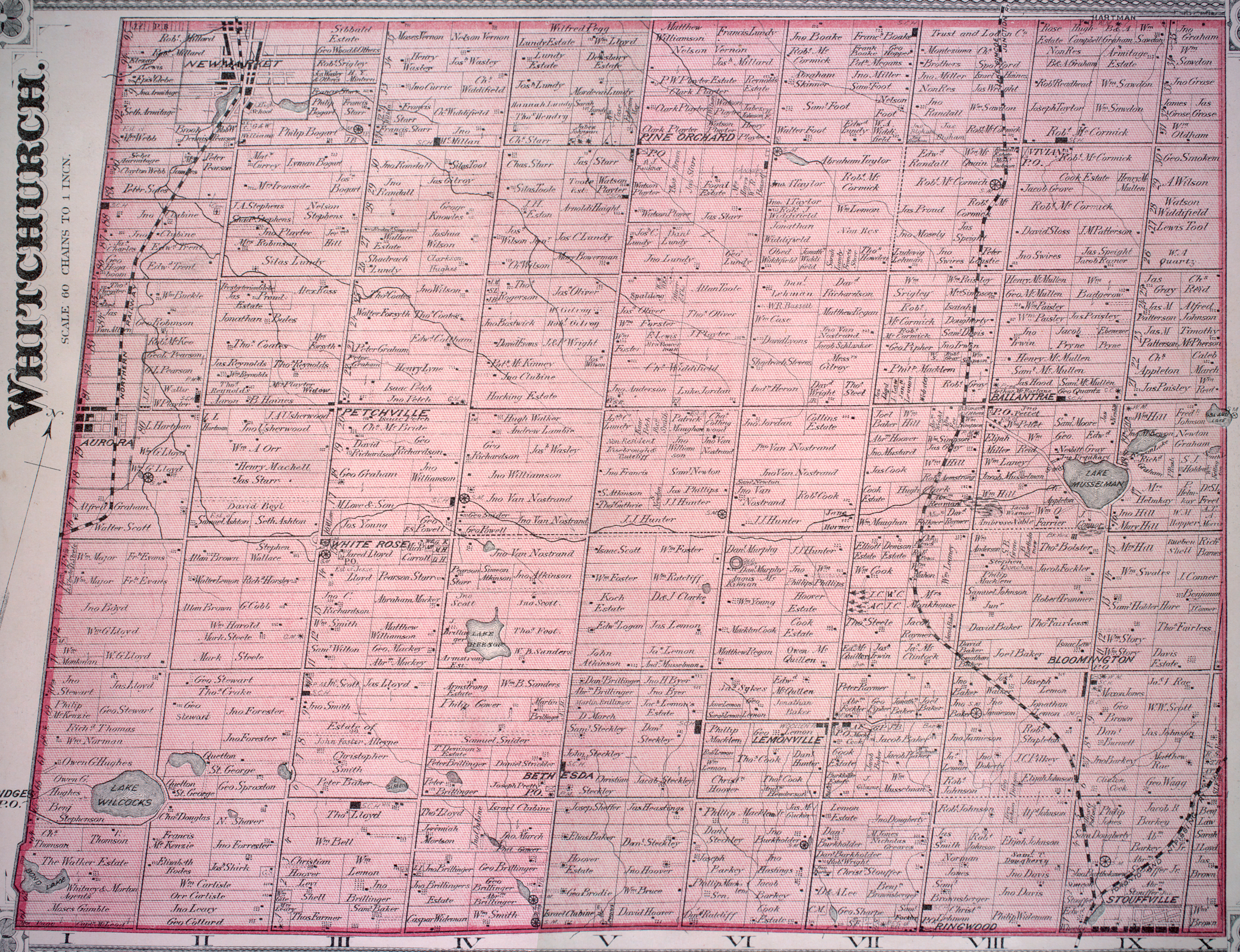
- ^ For a complete history of Musselman's Lake, see Jean Barkey et al, Whitchurch Township (Erin, ON: Boston Mills, 1993), 102-105. See also the detailed 1878 map, "Township of Whitchurch," Illustrated historical atlas of the county of York and the township of West Gwillimbury & town of Bradford in the county of Simcoe, Ont. (Toronto: Miles & Co., 1878); "The Community of Musselman's Lake: A Little History," Musselman's Lake Residents Association (MLRA) official website. Cf.
- ^ "My Favourite Stouffville Spots - Musselman's Lake | Vanessa Burton | RE/MAX All-Stars Realty Inc".
- ^ "My Favourite Stouffville Spots - Musselman's Lake | Vanessa Burton | RE/MAX All-Stars Realty Inc".
- ^ Sandra Bolan, "Musselman's Lake: Stouffville council makes it official," Stouffville Sun-Tribune, July 18, 2012.
- ^ Duncan Fletcher, "[1]," Stouffview Review, June 19, 2017.