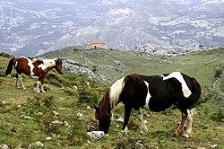
Morcín is a municipality in the Autonomous Community of the Principality of Asturias, Spain.[2] It is bordered on the north by Santo Adriano and Ribera de Arriba, on the east by Ribera and Mieres, on the south by Riosa on the west by Quirós.[3]
Morcín | |
|---|---|
 Asturcones in the Morcín landscape | |
 | |
| Coordinates: 43°17′N 5°53′W / 43.283°N 5.883°W | |
| Country | |
| Autonomous community | |
| Province | Asturias |
| Comarca | Oviedo |
| Judicial district | Mieres |
| Capital | Santa Eulalia de Morcín |
| Government | |
| • Alcalde | Jesús Álvarez Barbao (PSOE) |
| Area | |
| • Total | 50.05 km2 (19.32 sq mi) |
| Highest elevation | 1,712 m (5,617 ft) |
| Population (2018)[1] | |
| • Total | 2,631 |
| • Density | 53/km2 (140/sq mi) |
| Demonym | morciniego/a |
| Time zone | UTC+1 (CET) |
| • Summer (DST) | UTC+2 (CEST) |
| Postal code | 33161 a 33163 |
| Official language(s) | Asturian, Spanish |
| Website | Official website |
You can help expand this article with text translated from the corresponding article in Spanish. (March 2009) Click [show] for important translation instructions.
|
Parishes edit
Twin towns edit
- Arroyo Naranjo, Cuba
- Bir Enzaran, Western Sahara
- Lécousse, France
Gallery edit
-
Torreón de Peñerudes
-
Hermitage of Santiago, in the Monsacro mountain; Morcín, Asturias
-
Church of the parish of San Miguel de Argame
-
Church of the parish of San Antonio de la Foz; La Foz de Morcín
-
Hermitage of Santa Cecilia en el Vallín
-
Church of the parish of Santa Eulalia de Morcín
-
Embalse de Alfilorios
-
Cofradía Amigos de los Nabos
-
Medieval chapel in Monsacro mountain
References edit
- ^ Municipal Register of Spain 2018. National Statistics Institute.
- ^ Arias, Pablo (2009). "Rites in the Dark? An Evaluation of the Current Evidence for Ritual Areas at Magdalenian Cave Sites". World Archaeology. 41 (2): 262–294. ISSN 0043-8243.
- ^ "Bibliografía Hispánica". Revista Hispánica Moderna. 21 (3/4): 379–424. 1955. ISSN 0034-9593.
External links edit
- Federación Asturiana de Concejos (in Spanish)


