Mill Street is a prominent street in the city of Perth, Scotland. Established in at least the 18th century, it runs for about 0.25 miles (0.40 km), from Bridge Lane in the east South Methven Street in the west, passing through roughly two-thirds of the northern third of the city centre.[1]
.jpg) Mill Street in 2023 | |
 | |
| Length | 0.25 mi (0.40 km) |
|---|---|
| Location | Perth, Perth and Kinross, Scotland |
| East end | Bridge Lane |
| West end | South Methven Street |
| Construction | |
| Completion | 18th century |
Perth developed from an initial plan of two parallel streets: South Street and High Street in the 15th century.[1][2] Mill Street, to the north of High Street, followed shortly thereafter. High and South Streets became linked by several vennels leading north and south, and a couple more appeared that connected Mill Street to High Street. Kinnoull Street is the only road that connects to it throughout its quarter-mile length.
Lower City Mills, a Category A listed structure, was established in West Mill Street in 1715, but mills had previously been on the site before the street was officially recognised as such.[3]
Pullar House, on Mill Street, was once used by J. Pullar and Sons dyeworks, the largest industry in Perth at one time, and has since been converted into office use for Perth and Kinross Council.[4]
The ancient Perth Lade passes beneath Mill Street on the final stretch of its 4.5 mi (7.2 km) journey east from Huntingtower and Ruthvenfield to Tay Street, where it discharges into the River Tay.[5]
The entrance to Perth Theatre was moved to Mill Street in the 21st century, replacing the notable one on High Street.[6]
While Perth bus station is mostly used for out-of-town routes, routes in and around Perth originate and terminate on Mill Street.[7]
Vennels edit
The below vennels begin or end on Mill Street.
Buildings edit
-
 The former Pullar House, at 36 Mill Street, pictured in 2008
 -
 The Sandeman stands at the corner of Mill Street and Kinnoull Street
 -


Map edit
-
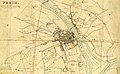 This 1832 map of Perth, by James Gardner, shows Mill Street as one of the three main thoroughfares of the time

References edit
- ^ a b Ordnance Gazetteer of Scotland: A Graphic and Accurate Description of Every Place in Scotland, Francis Hindes Groome (1901)
- ^ Perth High Street – Landscapes, BBC
- ^ The Tourist's Hand-book to Perth and Neighbourhood (1849), p. 38
- ^ "Perth City Centre Conservation Area Appraisal" (PDF). Perth and Kinross Council. Archived from the original (PDF) on 18 July 2011. Retrieved 22 December 2009.
- ^ "Take a Hike: The Lade, Perth, Perth & Kinross" - The Courier, 20 April, 2019
- ^ "Perth Theatre". charcoalblue. Archived from the original on 8 July 2011. Retrieved 7 March 2011.
- ^ "Perth bus users and drivers are warned as roadworks set to start on Mill Street" – Daily Record, 27 March 2016
- ^ "Perth projects its medieval past with VR" – The Sunday Times, 7 July, 2017
- ^ a b Streets, Lanes, Entries, &c. – Leslie's directory for Perth and Kinross (1911), p. 12
- ^ Cow Vennel – Google Street View, October 2015
- ^ Medieval Walk – Perth & Kinross Museums & Galleries
- ^ Cutlog Vennel – Google Maps
- ^ Leslie's directory for Perth and Kinross (1911), p. 13