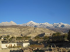
Lomanthang (Nepali: लोमान्थाङ) is a rural municipality in Mustang district in Gandaki Province of western Nepal.[2] It is located at the northern end of the district, bordering the Tibet Autonomous Region of China to the north and Dalome rural municipality of Mustang in the south.
Lo Manthang
लोमान्थाङ | |
|---|---|
 Barley and Buckwheat fields of Lomangthang, Upper Mustang. | |
| Nickname: The Walled City | |
 Lomanthang (the uppermost part of Mustang district) | |
 Lo Manthang Location in Gandaki Province  Lo Manthang Lo Manthang (Nepal) | |
| Coordinates: 29°10′59″N 83°57′24″E / 29.18306°N 83.95667°E | |
| Country | |
| Province | Gandaki Province |
| District | Mustang |
| Settled | 1380 |
| Established (rural municipality) | 10 March 2017 |
| Government | |
| • Type | Rural council |
| • Body | Lomanthang Rural Council |
| • Chairperson | Suwarn Kumar Bist (NC) |
| • Deputy-Chairperson | Pema Dolma Bist (NC) |
| Area | |
| • Total | 727 km2 (281 sq mi) |
| Elevation | 3,840 m (12,600 ft) |
| Population (2011) | |
| • Total | 1,899 |
| • Density | 2.6/km2 (6.8/sq mi) |
| Time zone | UTC+5:45 (NST) |
| Website | lomanthangmun |
Lo is the northern two-thirds of Mustang district, culturally and linguistically influenced by Tibet, while the southern third is called Thak, the homeland of Thakali people who speak a different language and have a synthesis of Tibetan and Nepalese culture. In 2007, a series of at least twelve caves were discovered north of Annapurna and near the village, decorated with ancient Buddhist paintings and set in sheer cliffs at an elevation of 14,000 feet (4,300 m).[3] The paintings show Newari influence, dating to approximately the 13th century, and also contain Tibetan scripts executed in ink, silver and gold and pre-Christian era pottery shards.[3] Explorers found stupas, decorative art and paintings depicting various forms of the Buddha, often with disciples, supplicants and attendants, with some mural paintings showing sub-tropical themes containing palm trees, billowing Indian textiles and birds.[3]
History edit
Lo Manthang was the walled capital of the Kingdom of Lo from its founding in 1380 by Ame Pal who oversaw construction of the city wall and many of the still-standing structures.[4] After the Shahs of Gorkha forged Nepal out of numerous petty kingdoms in the 18th century, Lo became a dependency but kept its hereditary rulers. This arrangement continued as long as Nepal remained a kingdom, until the country was declared a republic in 2008 and Jigme Dorje Palbar Bista (c.1933–2016) was stripped of his title.[5] His protector King Gyanendra suffered the same fate, however the raja or gyelpo of Mustang was 25th in a direct line of rulers dating back to 1380 AD. Gyanendra was only the eleventh Shah ruler since Prithvi Narayan Shah conquered Kathmandu in 1768.
More prosaically, Lo Manthang became a village development committee in Mustang district of Dhawalagiri zone. The 1991 census counted 876 people living in 178 households in the VDC.[6] The population includes ethnic Lhobas.[3]
Demographics edit
At the time of the 2011 Nepal census, Lomanthang Rural Municipality had a population of 2,350. Of these, 87.5% spoke Lhopa, 7.0% Gurung, 3.6% Nepali, 1.2% Magar and 0.7% other languages as their first language.[7]
In terms of ethnicity/caste, 87.6% were Lhopa, 7.1% Gurung, 2.3% Thakuri, 1.5% Magar and 1.5% others.[8]
In terms of religion, 92.8% were Buddhist and 7.1% Hindu.[9]
In terms of literacy, 40.1% could read and write, 2.1% could only read and 57.7% could neither read nor write.[10]
Administration edit
The total area of the Lo Manthang rural municipality is 727 square kilometres (281 sq mi) and the total population according to the 2011 census is 1899. The rural municipality is divided into 5 wards.[11]
Previously Lomanthang was a village development committee which was upgraded into a rural municipality merging adjoining VDCs of Chhoser and Chhonhup.[11] The rural municipality came into existence on 10 March 2017, fulfilling the requirement of the new Constitution of Nepal 2015 when the Ministry of Federal Affairs and General Administration replaced all old VDCs and municipalities into 753 new local level bodies.[12][13]
Transport edit
Lo Manthang is 20 kilometres (12 mi) by unpaved road from a border crossing into Zhongba County of Shigatse Prefecture, TAR. This road continues about 50 kilometres (31 mi) from the border to China National Highway 219, which follows the valley of the Yarlung Tsangpo River.
The Government of Nepal has built a road north along the Kali Gandaki River, to within 9 kilometres (6 mi) of Lo Manthang. There are also scheduled flights from Kathmandu and Pokhara to Jomsom Airport, located 50 kilometres (31 mi) south of Lo Manthang.
Tourism and access edit
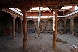
The village is noted for its tall whitewashed mud-brick walls, gompas and the Raja's or Royal or King's Palace, a nine-cornered, five-story structure built around 1400.[14] There are four major temples: Jampa Lhakhang or Jampa Gompa, the oldest, built in the early 15th century and also known as the "God house"; Thubchen Gompa, a huge, red assembly hall and gompa built in the late 15th century and located just southwest of Jampa Gompa; Chodey Gompa, now the main city gompa; and the Choprang Gompa, which is popularly known as the "New Gompa".[15][16]
Even though foreign visitors have been allowed in the kingdom since 1992, tourism to Upper Mustang remains limited, with just over 2000 foreign tourists in 2008.[3]
The Nepalese Department of Immigration requires foreign visitors to obtain a special permit, which costs $50 per day per person, and liaison (guide) to protect local tradition from outside influence as well as to protect their environment.[17]
2015 Earthquake edit
The April 2015 Nepal earthquake caused multiple cracks in the 600-year-old Lo Manthang Royal Palace.[18][19]
Gallery edit
-
 The Royal Palace in Lo Manthang
 -
 Lo Manthang
 -
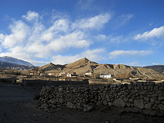
 The settlement of Lo Manthang
 -
 Nepal Tourism Center, Upper Mustang
 -
 Jampa Lhakhang
 -
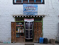 Shop
Shop -
 Choerten
 -
 Lotus Holiday Inn


See also edit
References edit
- ^ "स्थानीय निर्वाचन २०७४ - निर्वाचन विवरण तथा नतिजा - मुस्ताङ - लोमन्थाङ".
- ^ "स्थानीय तहहरुको विवरण" [Details of the local level bodies]. www.mofald.gov.np/en (in Nepali). Ministry of Federal Affairs and Local Development. Archived from the original on 31 August 2018. Retrieved 17 July 2018.
- ^ a b c d e Gopal Sharma, Explorers find ancient caves and paintings in Nepal, Reuters, May 3, 2007, Accessed October 28, 2012
- ^ Peissel, Michel (1992) [1967]. Mustang - A Lost Tibetan Kingdom (2nd ed.). Book Faith India, Delhi. pp. 227–31.
- ^ "China View news". Archived from the original on March 4, 2009.
- ^ "Nepal Census 2001". Nepal's Village Development Committees. Digital Himalaya. Archived from the original on 12 October 2008. Retrieved 15 November 2009..
- ^ NepalMap Language [1]
- ^ NepalMap Caste [2]
- ^ NepalMap Religion [3]
- ^ NepalMap Literacy [4]
- ^ a b "District Corrected Last for RAJAPATRA" (PDF). www.mofald.gov.np. Retrieved 17 July 2018.
- ^ "New local level structure comes into effect from today". www.thehimalayantimes.com. The Himalayan Times. 10 March 2017. Retrieved 17 July 2018.
- ^ "New local level units come into existence". www.kathmandupost.ekantipur.com. 11 March 2017. Retrieved 18 July 2018.
- ^ Mustang: The Forbidden Kingdom Archived 2007-06-30 at the Wayback Machine, Royal Mountain Travel, 2004, Accessed May 3, 2007.
- ^ Upper Mustang Trek Archived 2013-06-02 at the Wayback Machine, Osho World Adventure Pvt. Ltd., Accessed June 2, 2013.
- ^ Prasad, Madhav (2018-08-13). "Things to do in Mustang Nepal - Things You Shouldn't Miss in Mustang". Mosaic Adventure. Retrieved 2023-06-26.
- ^ Nepal Trekking Permit Fees Archived 2013-07-15 at the Wayback Machine, TAAN Nepal, Accessed June 2, 2013.
- ^ Quake-hit Upper Mustang still in ruins, myrepublica.com, 25 November 2015. Retrieved 18 April 2018.
- ^ Local people have reconstructed Lomanthang Palace on their own, nepalnow.org, 31 October 2016. Retrieved April 19, 2018.
Bibliography edit
- Maïe Kitamura, La cité fortifiée de Lo Manthang, Mustang, Nord du Népal. Paris, Éditions Recherches, 2011. 214 plans & drawings, photography. ISBN 978-2-86222-077-2. [5]