Kumbarilla is a town and rural locality in the Western Downs Region, Queensland, Australia.[2][3] In the 2016 census, the locality of Kumbarilla had a population of 197 people.[1]
| Kumbarilla Queensland | |||||||||||||||
|---|---|---|---|---|---|---|---|---|---|---|---|---|---|---|---|
 Kumbarilla | |||||||||||||||
| Coordinates | 27°18′57″S 150°52′34″E / 27.3158°S 150.8761°E | ||||||||||||||
| Population | 197 (2016 census)[1] | ||||||||||||||
| • Density | 0.7893/km2 (2.044/sq mi) | ||||||||||||||
| Postcode(s) | 4405 | ||||||||||||||
| Area | 249.6 km2 (96.4 sq mi) | ||||||||||||||
| Time zone | AEST (UTC+10:00) | ||||||||||||||
| Location | |||||||||||||||
| LGA(s) | Western Downs Region | ||||||||||||||
| State electorate(s) | Warrego | ||||||||||||||
| Federal division(s) | Maranoa | ||||||||||||||
| |||||||||||||||
Geography edit
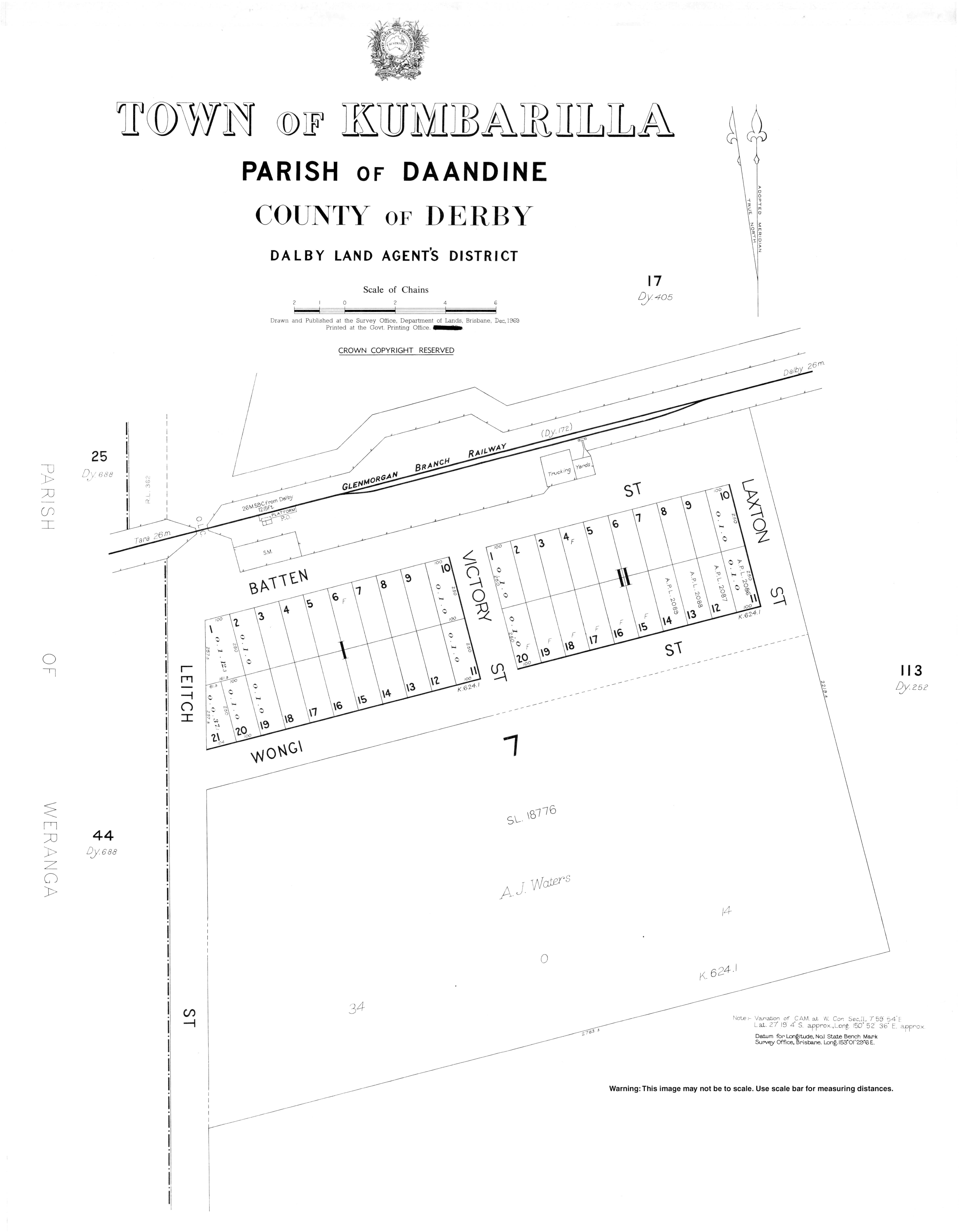
The locality ranges from 350m to 400m above sea level. The town is located in the south-west corner of the locality immediately to the south of the Kumbarilla railway station (27°18′54″S 150°52′34″E / 27.3150°S 150.8761°E) on the Glenmorgan railway line;[4] there are very few buildings in the surveyed town plan area.[5][6] Another station on the line was Gulera railway station (27°17′42″S 150°56′23″E / 27.2950°S 150.9396°E) which is now abandoned.[4]
The Glenmorgan railway line passes from east (Ducklo) to south-west (Weranga) through the southern part of the locality.
The Moonie Highway also passes from the south-east (Ducklo) to the south (Marmadua), always south of the railway line and does not pass through the town; the junction of the highway with the Surat Developmental Road is at the south-western edge of the locality.[5]
The Braemer State Forest is in the north-west of the locality. In addition, there are two smaller state forests in the locality: Daandine State Forest and Weranga State Forest. Apart from these, the land is predominantly freehold used for grazing.[5]
Despite its name, the Kumbarilla State Forest is not within Kumbarilla but is immediately to the south of Kumbarilla's southern border in Marmadua and Halliford.[5]
Geologically Kumbarilla is part of the Surat Basin.
History edit
The town takes its name from its railway station which was in turn an Aboriginal word in a local dialect meaning ironbark tree/timber.[2][7]
Kumbarilla Provisional School opened in 1913 and became Kumbarilla State School on 1 December 1918. The school closed about 1923.[8]
In March 1918, the Queensland government offered 18 town lots of 1 rood (0.25 acres; 1,000 m2) for sale as perpetual leases.[9]
In the 2006 census, Kumbarilla had a population of 241 people.[10]
In the 2016 census, the locality of Kumbarilla had a population of 197 people.[1]
Economy edit
Almost all of Kumbarilla is subject to a petroleum lease for coal seam gas with a grid of wells and pipelines in the northern and south-western parts of the locality. The Ruby Jo gas compression facility operated by QGC is located on Kumbarilla road south of the Braemer State Forest.[5][11]
Education edit
There are no schools in Kumbarilla. The nearest government primary schools are Tara Shire State College in Tara to the west, Kogan State School in neighbouring Kogan to the north, and Dalby State School in Dalby to the north-west. The nearest government secondary schools are Tara Shire State College in Tara and Dalby State High School in Dalby.[5]
Popular culture edit
Kumbarilla is one of the places listed in the first version of the song I've Been Everywhere.
References edit
- ^ a b c Australian Bureau of Statistics (27 June 2017). "Kumbarilla (SSC)". 2016 Census QuickStats. Retrieved 20 October 2018.
- ^ a b "Kumbarilla – town (entry 18594)". Queensland Place Names. Queensland Government. Retrieved 15 January 2017.
- ^ "Kumbarilla – locality (entry 47722)". Queensland Place Names. Queensland Government. Retrieved 15 January 2017.
- ^ a b "Railway stations and sidings - Queensland". Queensland Open Data. Queensland Government. 2 October 2020. Archived from the original on 5 October 2020. Retrieved 5 October 2020.
- ^ a b c d e f "Queensland Globe". State of Queensland. Retrieved 29 August 2022.
- ^ "Kumbarilla – railway station in Western Downs Region (entry 18595)". Queensland Place Names. Queensland Government. Retrieved 6 June 2019.
- ^ "NOMENCLATURE OF QUEENSLAND—168". The Courier-mail. No. 818. Queensland, Australia. 14 April 1936. p. 12. Archived from the original on 29 August 2022. Retrieved 15 January 2017 – via National Library of Australia.
- ^ Queensland Family History Society (2010), Queensland schools past and present (Version 1.01 ed.), Queensland Family History Society, ISBN 978-1-921171-26-0
- ^ "Advertising". The Dalby Herald. Queensland, Australia. 2 March 1918. p. 2. Archived from the original on 29 August 2022. Retrieved 25 April 2020 – via Trove.
- ^ Australian Bureau of Statistics (25 October 2007). "Kumbarilla (SSC)". 2006 Census QuickStats. Retrieved 15 January 2017.
- ^ Prowse, Stephen (April 2016). "The footprint of Coal Seam Gas developments: a case study in two Queensland State Forests" (PDF). Archived (PDF) from the original on 16 January 2017. Retrieved 15 January 2017.