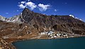
Gokyo is a small village in Solukhumbu District in the Himalayas of Nepal, at the foot of Gokyo Ri and located on the eastern shore of the third Gokyo Lake, Dudh Pokhari. To the southeast is the village of Chharchung. Gokyo is best viewed on Google Earth at 27°57′16″N 86°41′43″E / 27.95444°N 86.69528°E.
Gokyo
गोक्यो | |
|---|---|
Village | |
 Gokyo | |
 Gokyo Location in Nepal | |
| Coordinates: 27°57′16″N 86°41′43″E / 27.95444°N 86.69528°E | |
| Country | Nepal |
| Zone | Sagarmatha Zone |
| District | Solukhumbu District |
| VDC | Khumjung |
| Elevation | 4,750 m (15,580 ft) |
| Time zone | UTC+5:45 (Nepal Time) |
The village is located at an elevation of 4,750 m (15,584 ft),[1] making it one of the highest settlements in Nepal and in the world. Almost all the buildings are guest houses for trekkers. The people who live in the village leave during the winter and move to other (lower) villages such as Namche Bazaar.
In 1995, an avalanche killed 42 people, including 17 foreign nationals (13 Japanese, two Canadians, one Irish woman and a German). A cyclone in the Bay of Bengal had resulted in 6 ft (1.8 m) of snow being dumped into the mountains during the previous week, significantly increasing the avalanche hazard.[2]
- Gokyo
-
-

-


References edit
- ^ Reynolds, Kev (23 April 2012). Everest: A Trekker's Guide: Trekking Routes in Nepal and Tibet. Cicerone Press Limited. p. 151. ISBN 978-1-84965-480-7. Retrieved 13 May 2012.
- ^ "The Gokyo Avalanche of November 1995". caingram.info. Retrieved 29 April 2014.
External links edit
This article about a location in Solukhumbu District, Nepal is a stub. You can help Wikipedia by expanding it. |