The geology of Saskatchewan can be divided into two main geological regions, the Precambrian Canadian Shield and the Phanerozoic Western Canadian Sedimentary Basin. Within the Precambrian shield exists the Athabasca sedimentary basin. Meteorite impacts have altered the natural geological formation processes. The prairies were most recently affected by glacial events in the Quaternary period.[1]

Canadian Shield edit

The Canadian shield, Precambrian shield, makes up the bedrock geology highlighted by rocks and lakes[2] and a boreal forest area. There are transitional areas between boreal and tundra flora.[3] The lower boundary of the Canadian Shield cuts across the province diagonally from the latitude 57 degrees in the north west to 54 degrees in the south east.[4] Three orogenies formed the Precambrian shield, the Kenoran (Laurentian-Algoman), Hudsonian (Penokean) and Grenville Orogeny.[5][6][7] Between 2.2 and 2.5 billion years ago was the Kenoran Orogeny, which was overlain by the Hudsonian Orogeny 1700 to 1900 million years ago.[MapA][5] The earth was experiencing hotter and more volatile Archean tectonics, evidencing island arc volcanic activity and mountain building.[8][9][10][11][12] The Trans-Hudson Orogen occurred when a number of Archean continental blocks came together, including the Superior Craton from the southeast and Hearne-Rae craton from the northwest. A microcontinent named the Sask Craton was underlain in this collision zone.[13] The Canadian Grenville province occurred between 1080 and 980 Ma and did not affect the geology of the Canadian Shield in Saskatchewan. The Grenvillian Orogeny deformed much of eastern Canada, and includes the Grenville Front Tectonic Zone in Quebec and Labrador, the Appalachian structural front to the south between what we now name the Great Lakes and Newfoundland.[14]
The Flin Flon greenstone belt, also referred to as the Flin Flon-Snow Lake greenstone belt, is a Precambrian greenstone belt located in the central area of Manitoba and east-central Saskatchewan, Canada. It lies in the central portion of the Trans-Hudson Orogeny and was formed by arc volcanism during the Paleoproterozoic Era.[15]
Athabasca basin edit
The Athabasca basin, a historical fluvial siliciclastic basin with sediments from the Hudsonian mountains with the occasional rare marine sequence.[16] The Athabasca basin was formed during the Statherian or Paleohelikian 1.7 to 1.6 billion years ago when coarse fluvial and marine clastic sediments were laid down containing gold, copper, lead, zinc, and uranium oxides.[5][17] The highest grade uranium deposits in the world are found at the unconformity between these clastic layers and the Precambrian bedrock.[18] The Athabasca Sand Hills protected by The Athabasca Sand Dunes Provincial Park are unique feature of the Canadian Shield. The hills are located in northern Saskatchewan and border Lake Athabasca, which straddles the Alberta and Saskatchewan border.[19][20]
Phanerozoic Western Canadian Sedimentary Basin edit
There were three depositional stages for the Western Canada Sedimentary Basin which were dependent on plate tectonics of the era. Present-day North America was identified to lay upon the Proterozoic super-continent, Rodinia.[21]

This continent broke apart about 700 million years ago and formed other continents, one of which was Laurentia or the North American Craton. Laurentia drifted south of the equatorial zone. As this new smaller continent was smaller than Rodinia, it had some surface area under water level, including area designated as the Phanerozoic basin.[21]Cambrian 544-505 Ma to Mississippian 362-320 Ma period laid down base clastics, then platform carbonates and evaporites. These deposits form the origins of potash evaporites for the potash industry.[18] Laurentia began to rise at the close of the Cambrian Period. Huge flooding occurred during the Middle Ordovician period 505-441 Ma.[21] Laurentia had shifted again, and the region of Saskatchewan was now north of the equator and some raising exposing the land again. Re-flooding in the Late Ordovician age with warm water increased calcium carbonate sedimentation, and marine life.

The Williston basin was formed creating a lowered land area during this period filling with the Winnipeg Sea.[5] The Williston basin was mainly south of Saskatchewan but extended north into the Saskatchewan plains area.
Laurasia was created near the end of the Silurian Period. Laurasia was formed from the joining of Laurentia with Gondwana and two smaller continents which had broken off Rodinia. The orogeny between Laurasia and Gondwana created the Appalachian Mountains, and an exodus of water from the Laurasian land surface. In the early Devonian Period 418-361 Ma, Laurasia separated from Gondwana, creating a depressions or land separations through the continent. One low-lying area occurred along the edge between the Cambrian shield and the Phanerozoic basin, the other trough lay along southwestern Saskatchewan extending east and west along the plains areas we know today. The Saskatchewan region was again south of the equator and under water, with reefs forming. A major barrier reef formed in the area now known as British Columbia, creating higher salinity levels east of the reef. Calcium carbonate, halite, gypsum, and potash were evaporite deposits. The Antler orogeny on the southwest coast of Laurasia caused upheavals.[21]
Following this orogeny, during the Carboniferous Period in the Mississippian epoch 362-320 Ma the Williston Basin again subsided and the area of the Phanerozoic basin was again mainly under tropical marine water. Oil production of southeastern Saskatchewan emerges mainly from Mississippian rocks.

During the Pennsylvanian epoch 320-286 Ma of the Carboniferous period, Laurasia joined with Gondwana to become Pangea. This supercontinent rose above sea level, in an equatorial zone producing desert-like conditions.[21] The late Triassic 245-208 Ma or early Jurassic 208-144 Ma to Jura-Cretaceous 208-66 Ma where red clay beds and marine clastics were deposited.[18] Pangea began to separate during the Jurassic period.[21]
The Kimberlite Volcanoes of this period produce the Kimberlite diamonds which are mined today.[22][23] Near Fort à La Corne (FALC) were Kimberlite volcanoes in Archean cratons.[18][24][25]

The Cretaceous 144-66 Ma to Miocene periods deposited clastic sediments from the Cordilleran orogeny.[18] This period saw 40% of the region now called North America below sea level under the Rocky Mountain Seaway which comprised the Western Interior Seaway and the Hudson Seaway, and Labrador Seaway.[5][21] The Cretaceous period rocks produce medium and heavy gravity oil in the Lloydminster region, and of the western province.[21] The Laramide orogeny episode near the end of the Cretaceous and early Tertiary period caused larger gravels to be deposited from the newly formed Rocky Mountains when the Kula and Farallon Plates subducted below the North American plate.[26] In the Cypress Hills area and southern Saskatchewan, lignite deposits developed from the marshes of these Tertiary rivers.[21] The sea waters have retreated from the areas known as Saskatchewan. The Ravenscrag formation, Cypress Hills, and Wood Mountain Formations were notable gravel deposits from the Tertiary period.[5][17][27] The Williston Basin affects this region at the southern edge. Tectonic movements and global changes in the sea level have given rise to a source of oil, natural gas, and coal.[18]
Quaternary period edit
During the Quaternary period, between 2 and 3 million years ago, the prairies were covered by a glacier, the Laurentide Ice Sheet.

It was 3 kilometres (1.9 mi) thick, which advanced and receded several times across the prairies. There were multiple glaciations affecting the Saskatchewan area during the Pre-Illinoian, Illinoian, and Wisconsin stages of the last ice age. These glaciations occurred during the Quaternary period, which comprises the last two million years.[21] Northern Saskatchewan and the shield area shows the effects of glacial erosion and scour; the Western Canada Sedimentary Basin is a location of glacial deposition and collection.[18] In southern Saskatchewan there are late Pliocene, pre-Illinoian continental glaciation sand and gravel deposits left behind from water deposition (alluvial) and glacial edge deposits (colluvial).[28]: 142 By the study of till, terrain, the limits of the Illinoian glaciation are evidenced around Willow Bunch Lake, Wood Mountain, Cypress Hills area.[28]: 144

The melting glaciers left behind sand and, silt outwash plains. The Great Sand Hills of Saskatchewan are evidence of winds and sand storms which have accumulated the sands left behind. Retreating glaciers left meltwater, which pooled in lakes.

Glacial Lake Regina covered south-central area, and Glacial Lake Agassiz covered much of Saskatchewan and neighbouring regions of the US and Manitoba.[6] The ice and water retreated, and the lake beds formed flat plains. The land exposed from under the ice sheets was rubble, and ridges of gravel.[30]: 53
Glaciotectonic hills edit
The Dirt Hills and Cactus Hills represent the most defined and biggest Møns Klint glaciotectonic hills of the world. There are other similar hills created by ice action in southern Saskatchewan as well.[31] Glaciotectonic hills or ice-shoved hills show thrusting, folds, ridges and push moraines.[32][Map] These hills consist of upper Cretaceous bedrock which rises to an elevation of 880 metres (2,890 ft) in the Dirt Hills. To the north is the Regina Lake Plain, which is 300 metres (980 ft) lower in elevation. The Missouri Coteau from whence the hills arise, is 120 metres (390 ft) lower than these hills. Between the Alberta and Saskatchewan Plains is the Missouri Coteau, dead ice moraine, a major escarpment, a long meandering ridge of hill country.[30]: 55 [31]: 63 [Map2] The area is probably underlain with marine shale of the Bearpaw Formation.[31]: 69 This area remained above the ice sheets, being pushed and folded by the glacier movement.[18]
Astroblemes edit
There are six notable meteorite or comet impact craters in Saskatchewan. Carswell, Deep Bay, and Gow Lake have affected the Canadian Shield area of the north. In the southern Phanerozoic crater are the Viewfield, Elbow, and Maple Creek structures.[18] The Carswell structure is the largest astrobleme at 35 kilometres (22 mi) in diameter.[33] It is estimated that the impact to the Athabasca basin occurred about 478 million years ago during the Ordovician period. The thrust of the impact affected the Athabasca Rock groups. The William River Subgroup and the Douglas and Carswell formations show inversions, thrusting and disruptions.[34] The impact that occurred about 210 million years ago has created the Gow Lake Structure. This lake is 5 kilometres (3.1 mi) in diameter with Calder island centrally located.[34]La Ronge is 160 kilometres (99 mi) south-southwest of the crater location.[33] The other impact crater of the Cambrian shield is the Deep Bay Structure, which created a bay in the southerly part of Reindeer Lake. The crater is about 11 kilometres (6.8 mi) in diameter and about 220 metres (720 ft) at the deepest point. The circular impact ridge 100 metres (330 ft) above water level partially encompasses the crater area. There is some central uplift. The crater was formed about 50 to 150 million years ago.[34][35]Weyburn is west and Stoughton is north of the Viewfield Impact Structure, a small impact crater 2 kilometres (1.2 mi) in diameter. The impact occurred in the early Jurassic period about 190 million years ago. Oil and gas reserves have been found in the area of the rim breccia[33][34] Another impact crater in the Phanerezoic crater is the Maple Creek Structure. This impact affected Upper Cretaceous Bearpaw Formation sediments on the north edge of the Cypress Hills, and roughly occurred 75 million years ago. Maple Creek is located north northwest of this 6 kilometres (3.7 mi) diameter crater.[33][34] The Elbow Impact Structure is 8 kilometres (5.0 mi) in diameter and the impact occurred between 370 and 415 million years ago during the Devonian Period.[36] The crater is located in Maple Bush rural municipality north of Aitkow (Riverhurst) and west of Grainfield (Grainland). The Elbow crater is located south of the elbow of the South Saskatchewan, and south of Diefenbaker lake across the waters from the town of Elbow which is north of the South Saskatchewan River.
Notes edit
- MapA Map of Zin Bay region, Precambrian era - note Zin Bay is located in present day terms north of Athabasca Lake within Saskatchewan. Note also the large Tazin Lake comprising much of the area north of the present day treeline. The map shows the Martin Formation which shows rocks dating 1.63 billion years ago. The northeastern basement complex contains rocks which date 2.44 billion years ago. All of the map is Precambrian in age.[37][38]
- Map1 Glacial limits in North America of the glaciations.[28]
- Map Aerial photo of Crestwynd which is east of Old Wives Lake and west of Cactus Hills. The aerial photo shows ridges from north west to south east. Satellite imaging maps of southern Saskatchewan showing spring and winter images of the Cactus and Dirt Hills area of the Missouri Coteau.[31]: 28
See also edit
References edit
- ^ "Introduction to Saskatchewan's Geology". About Energy and Resources/Mineral Resources/Geological Info/GeolSask/SaskGeology. Government of Saskatchewan. Retrieved 2009-01-24.[permanent dead link]
- ^ Acorn, John (2007). Deep Alberta: Fossil Facts and Dinosaur Digs (Digitized by Internet Archive online). Royal Tyrrell Museum of Palaeontology (illustrated ed.). University of Alberta. pp. 30. ISBN 9780888644817. Retrieved 2009-01-21.
saskatchewan Canadian shield.
- ^ Ricketts, Taylor H. (1999). Terrestrial Ecoregions of North America: A Conservation Assessment (Digitized by Google books online) (illustrated ed.). Island Press. p. 366. ISBN 9781559637220. Retrieved 2009-01-21.
- ^ Ward, Norman (1985). "Saskatchewan - Geology". In Marsh, James H. (ed.). The Canadian Encyclopedia (Pat-Z ed.). Edmonton, AB, CA: Hurtig Publishers Ltd. p. 1635. ISBN 0-88830-269-X. (vol 2), (vol 1), (vol 3).
- ^ a b c d e f Byres, A.R. (1969). "Physical Geography Evolution of the present bedrock surface.". In J.H. Richards, K.I. Fung (ed.). Atlas of Saskatchewan. W.G.E. Caldwell, W.O. Kupsch. Saskatoon, SK, CA: University of Saskatchewan. pp. 44–45.
- ^ a b Harris, Ann G. (2003). Geology of National Parks (Digitized online by Google books). Esther Tuttle, Sherwood D. Tuttle (6, illustrated ed.). Kendall Hunt. pp. 303–305. ISBN 0-7872-9970-7. Retrieved 2008-01-21.Kenoran (Algoman) orogeny
- ^ Percival, J.A. (2002-03-07). "BOOK REVIEWS" (PDF). THE TECTONICS OF THE CANADIAN SHIELD. Edited by Jonn S. SrrwrqsoN. Western Superior NATMAP working group. This is the third volume in a series on the Canadian Shield, published by the Royal Society of Canada, and is called Special Publication No 4. Retrieved 2009-01-24. Kenoran (Algoman) orogeny
- ^ Percival, J.A. (2002-03-07). "Orogenic framework for the western Superior Province" (PDF). Western Superior NATMAP working group. Geolocial Survey of Canada. Archived from the original (PDF) on 2005-01-31. Retrieved 2009-01-24. Kenoran (Algoman) orogeny
- ^ Beauvais., Bill (2002-03-07). "15 billion to 570 million years before present : Beginning to Ediacaran". MIDSECTION PALEONICS. Archived from the original on 2008-10-12. Retrieved 2009-01-24. Kenoran (Algoman) orogeny
- ^ Rogers, John James (2004). Continents and Supercontinents (Digitized online by Google books). M. Santosh. Oxford University Press US. pp. 90–92. ISBN 0-19-516589-6. Retrieved 2008-01-21.Kenoran (Algoman) orogeny
- ^ Kollwitz, Johannes (1978). Oströmische Plastik der theodosianischen Zeit (Digitized online by Google books) (illustrated ed.). Walter de Gruyter. pp. 81–82. ISBN 3-11-004998-8. Retrieved 2008-01-21.Kenoran (Algoman) orogeny
- ^ Schopf, J. William (1992). The Proterozoic Biosphere: A Multidisciplinary Study (Digitized online by Google books). Cornelis Klein (illustrated, annotated ed.). Cambridge University Press. p. 44. ISBN 0-521-36615-1. Retrieved 2008-01-21.Hudsonian Orogeny
- ^ "Kimberlite Volcanoes". Stornoway Diamond Corporation. Archived from the original on 2008-10-16. Retrieved 2009-01-24.
- ^ Tollo, Richard P. (2007). Proterozoic Tectonic Evolution of the Grenville Orogen in North America (Digitized by Google books online). Richard P. Tollo (illustrated ed.). Geological Society of America. pp. 4–5. ISBN 9780813711973. Retrieved 2009-01-21.
- ^ NorrisTROYMET EXPLORATION CORP., Jessica; Tracy Hurley (September 24, 2007). "Report on the 2007 Diamond Drilling program, McClarty Lake Project, Manitoba The Pas Mining District" (PDF). Troymet Exploration Corp. and Aurora Geosciences Ltd. Retrieved 2009-01-24.
- ^ Ramaeker, P (2007). [geoscan.ess.nrcan.gc.ca/starweb/geoscan/servlet.starweb "Revised geological map and stratigraphy of the Athabasca Group, Saskatchewan and Alberta"]. Saskatchewan Geology. Natural Resources Canada. Retrieved 2016-04-20.
{{cite web}}: Check|url=value (help) - ^ a b "The Phanerozoic Basin in Detail". About Energy and Resources/Mineral Resources/Geological Info/GeolSask/PhanBasin Detail. Government of Saskatchewan. Retrieved 2009-01-24.[permanent dead link]
- ^ a b c d e f g h i Macdonald, R. (2006). "Geology". The Encyclopedia of Saskatchewan. Canadian Plains Research Centre, University of Regina. Archived from the original on 2009-06-19. Retrieved 2009-01-24.
- ^ Schwartzenberger, Tina (2005). The Canadian Shield (Digitized online by Google books) (illustrated ed.). Weigl Educational Publishers Limited. p. 23. ISBN 1-55388-148-6. Retrieved 2008-01-21.
- ^ Kissock, Heather (2002). Saskatchewan (Digitized online by Internet Archive) (illustrated ed.). Weigl Educational Publishers Limited. p. 8. ISBN 1-894705-46-7. Retrieved 2008-01-21.
Canadian Shield Saskatchewan.
- ^ a b c d e f g h i j Fung, Kai-iu (1999). Barry, Bill; Wilson, Michael (eds.). Atlas of Saskatchewan Celebrating the Millennium (Millennium ed.). Saskatchewan: University of Saskatchewan. pp. 71–88. ISBN 0-88880-387-7.
- ^ "Trans-Hudson Orogen Transect". About Energy and Resources/Mineral Resources/Geological Info/GeolSask/SaskGeology. Government of Saskatchewan. Archived from the original on 2011-07-06. Retrieved 2009-01-24.
- ^ Kirkley, Melissa B. (1998). "The Origin of Diamonds: Earth Processes". In Harlow, George E. (ed.). The Nature of Diamonds. Cambridge University Press. pp. 49–52. ISBN 9780521629355. Retrieved 2009-01-24.
- ^ Lefebvre, Nathalie. "Contrasting Eruption Styles of the 147 Kimberlite, Fort à la Corne, Saskatchewan, Canada" (PDF). Stephan Kurszlaukis. De Beers Canada Inc. Exploration Division, Kimberlite Petrology Unit. Retrieved 2009-01-24. [dead link]
- ^ "The Atlas of Canada - Location of Kimberlites". Natural Resources Canada. Government of Canada. 2004-01-29. Archived from the original (pdf) on 2009-01-26. Retrieved 2009-01-24.
- ^ Bird, P. "Formation of the Rockies III: A kinematic model based on geologic data". 40. (1998b) Kinematic history of the Laramide orogeny in latitudes 35° -49° N, western United States, Tectonics, 17, 780-801. Retrieved 2009-01-24.
- ^ Mossop, G.D (1994). "Geological Atlas of the Western Canada Sedimentary Basin". About Energy and Resources/Mineral Resources/Geological Info/GeolSask/SaskGeology. Canadian Society of Petroleum Geologists and Alberta Research Council. Archived from the original on 2008-12-26. Retrieved 2009-01-24.
- ^ a b c Ehlers, Jürgen; P. L. Gibbard (2004). Quaternary Glaciations - Extent and Chronology: Part III: South America, Asia, Africa, Australia, Antarctica (Digitized online by Google books) (illustrated ed.). Elsevier. pp. 135–140. ISBN 9780444515926. Retrieved 2009-01-21.
- ^ An early map of the extent of Lake Agassiz (by 19th century geologist Warren Upham). This map is now believed to underestimate the extent of the region once overlain by Lake Agassiz.
- ^ a b c Savage, Candace; James R. Page (2006). Prairie: A Natural History (Digitized online by Google books) (reprint, illustrated ed.). Greystone Books. p. 9. ISBN 1-55365-190-1. Retrieved 2008-01-21. Map of Missouri Coteau, Saskatchewan and Alberta plains.
- ^ a b c d e Aber, James S.; Ber, Andrzej (2007). Glaciotectonism (Digitized online by Google books) (illustrated ed.). Elsevier. p. 3. ISBN 9780444529435. Retrieved 2008-01-21.
- ^ Aber, J.S. (20 May 1997). "North American glaciotectonic map". GAGE Geospatial Analysis Glaciated Environments. Archived from the original on 31 January 2008. Retrieved 21 January 2008.
- ^ a b c d Harper, Charles (2006). "Astroblemes". The Encyclopedia of Saskatchewan Details. Canadian Plains Research Centre, University of Regina. Retrieved 2009-01-24.
- ^ a b c d e "Meteorite Impact Structures". About Energy and Resources/Mineral Resources/Geological Info/GeolSask/SaskGeology/Meteorite. Government of Saskatchewan. Retrieved 2009-01-24.[permanent dead link]
- ^ "Impact Craters on Earth - North America Part One". Blue Knight Productions. 2001–2006. Retrieved 2009-01-24. With photographs of Deep Bay, and Gow Lake craters
- ^ "Elbow". Earth Impact Database. Retrieved 2007-10-16.
- ^ Koster, F. (1968). Government of Saskatchewan - Publications Centre - kenoran orogeny The Geology of the Zin Bay Area by - RepNo121_Koster1968_MapNo121a.pdf Department of Mineral Resources - Geological Sciences Branch - Precambrian Geology Division (PDF). Online by Publications Centre. ISBN 1-55365-190-1. Retrieved 2008-01-21. Kenoran (Algoman) orogeny
- ^ Koster, F. (1968). Government of Saskatchewan - Publications Centre - kenoran orogeny The Geology of the Zin Bay Area by - The Geology of the Zin Bay Area by F. Koster - 1968 Related Documents report121.pdf Department of Mineral Resources - Geological Sciences Branch - Precambrian Geology Division (PDF). Online by Publications Centre. ISBN 1-55365-190-1. Retrieved 2008-01-21.
External links edit
- Ray, Arthur J.; Jim Miller; Frank Tough (2002). Bounty and Benevolence: A History of Saskatchewan Treaties (Digitized online by Google books) (reprint, illustrated ed.). McGill-Queen's Press - MQUP. ISBN 0-7735-2060-0. Retrieved 2008-01-21. Ethnohistorical geography of Saskatchewan
- Aber, James S. (2008). "ES 331/767 Lecture 5 Glacial Geomorphology Deformation". Earth Science Department. Emporia State University, Kansas, U.S.A. Retrieved 2008-01-21. Image of fractured cobbles at Dollard Saskatchewan
- Snoke, Arthur W.; Jan Tullis; Victoria Roy Todd (1998). Fault-related Rocks: A Photographic Atlas (Digitized online by Google books) (reprint, illustrated ed.). Princeton University Press. p. 344. ISBN 0-691-01220-2. Retrieved 2008-01-21.
- Caldwell, W.G.E. (1968). "SRC 8: The Late Cretaceous Bearpaw Formation In the South Saskatchewan River Valley". Saskatchewan Research Council. Energy and Resources Geo-Publications. Retrieved 2008-01-21.
- Caldwell, W.G.E.; North,B.R. (1970). "SRC 9: Foraminifera from the Late Cretaceous Bearpaw Formation in the South Saskatchewan River Valley". Saskatchewan Research Council. Energy and Resources Geo-Publications. Retrieved 2008-01-21.
- Caldwell, W.G.E. (1968). "SRC 8: The Late Cretaceous Bearpaw Formation In the South Saskatchewan River Valley". Saskatchewan Research Council. Energy and Resources Geo-Publications. Retrieved 2008-01-21.
The following five timelines show the geologic time scale to scale. The first shows the entire time from the formation of the Earth to the present, but this gives little space for the most recent eon. The second timeline shows an expanded view of the most recent eon. In a similar way, the most recent era is expanded in the third timeline, the most recent period is expanded in the fourth timeline, and the most recent epoch is expanded in the fifth timeline.
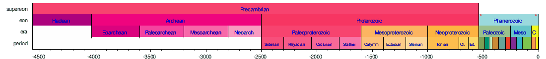


Horizontal scale is Millions of years (above timelines) / Thousands of years (below timeline)
