Fleuré (French pronunciation: [flœʁe] ⓘ) is a commune in the Orne department in north-western France.
Fleuré | |
|---|---|
 The chateau in Fleuré | |
Location of Fleuré  | |
 Fleuré  Fleuré | |
| Coordinates: 48°41′29″N 0°03′20″W / 48.6914°N 0.0556°W | |
| Country | France |
| Region | Normandy |
| Department | Orne |
| Arrondissement | Argentan |
| Canton | Magny-le-Désert |
| Intercommunality | Argentan Intercom |
| Government | |
| • Mayor (2020–2026) | Thierry Clérembaux[1] |
| Area 1 | 11.8 km2 (4.6 sq mi) |
| Population (2021)[2] | 202 |
| • Density | 17/km2 (44/sq mi) |
| Time zone | UTC+01:00 (CET) |
| • Summer (DST) | UTC+02:00 (CEST) |
| INSEE/Postal code | 61170 /61200 |
| Elevation | 156–265 m (512–869 ft) (avg. 164 m or 538 ft) |
| 1 French Land Register data, which excludes lakes, ponds, glaciers > 1 km2 (0.386 sq mi or 247 acres) and river estuaries. | |
Geography edit
The commune is made up of the following collection of villages and hamlets, Fleuriel and Fleuré.[3]
It is 1,180 hectares (4.6 sq mi) in size. The highest point in the commune is 165 metres (541 ft).
The Etangs stream, Marais de Fleuriel stream and the Bel Usse stream flow through the commune.
Notable buildings and places edit
- Stèle Étienne Panthou is a memorial remembering where a French Resistance fighter, Étienne Panthou, and an unknown person were executed in June 1944.[4]
-
 The Mayors office and Church
 -
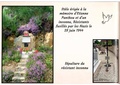 Stèle Étienne Panthou


See also edit
References edit
- ^ "Répertoire national des élus: les maires" (in French). data.gouv.fr, Plateforme ouverte des données publiques françaises. 13 September 2022.
- ^ "Populations légales 2021". The National Institute of Statistics and Economic Studies. 28 December 2023.
- ^ a b "Fleuré · 61200, France". Fleuré · 61200, France.
- ^ "Fleuré. Un hommage à deux résistants fusillés il y a 78 ans". alencon.maville.com.
Wikimedia Commons has media related to Fleuré (Orne).
This Orne geographical article is a stub. You can help Wikipedia by expanding it. |