
Size of this preview: 800 × 533 pixels. Other resolutions: 320 × 213 pixels | 640 × 427 pixels | 1,024 × 683 pixels | 1,280 × 854 pixels | 2,128 × 1,419 pixels.
Original file (2,128 × 1,419 pixels, file size: 767 KB, MIME type: image/jpeg)
| This is a file from the Wikimedia Commons. Information from its description page there is shown below. Commons is a freely licensed media file repository. You can help. |
Summary
| Description |
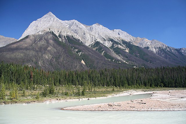
English: Chancellor Peak in Yoho National Park of Canada. Towering above Kicking Horse Valley. The river visible is Kicking Horse river. Photo taken from Trans-Canada Highway. The greyish areas of the forests are from a prescribed fire in 2005 Polski: Góra Chancellor Peak w Parku Narodowym Yoho, Kanada. Rzeka w dolnej części zdjęcia to Kicking Horse River. Zdjęcie wykonane z autostrady transkanadyjskiej. Szarawe obszary lasów to inwazja górskiego żuka sosnowego (Dendroctonus ponderosae). |
| Date | |
| Source | Own work |
| Author | Marek Ślusarczyk (Tupungato) Photo gallery |
| Permission (Reusing this file) |
Outside Wikipedia projects you must attribute the work to the author: Marek Ślusarczyk or www.microstock.pl. In case of any doubts feel free to e-mail me: marek (at) microstock pl. |
| Camera location | | View this and other nearby images on: OpenStreetMap |
|---|
Licensing
Marek Slusarczyk, the copyright holder of this work, hereby publishes it under the following license:
This file is licensed under the Creative Commons Attribution 2.5 Generic license.
Attribution: Marek Slusarczyk
- You are free:
- to share – to copy, distribute and transmit the work
- to remix – to adapt the work
- Under the following conditions:
- attribution – You must give appropriate credit, provide a link to the license, and indicate if changes were made. You may do so in any reasonable manner, but not in any way that suggests the licensor endorses you or your use.
This image has been assessed using the Quality image guidelines and is considered a Quality image.
|
File history
Click on a date/time to view the file as it appeared at that time.
| Date/Time | Thumbnail | Dimensions | User | Comment | |
|---|---|---|---|---|---|
| current | 20:52, 8 July 2009 | | 2,128 × 1,419 (767 KB) | Tupungato | == Summary == {{Information |Description={{en|Chancellor Peak in Yoho National Park of Canada. Towering above Kicking Horse Valley. The river visible is Kicking Horse river. Photo taken from Trans-Canada Highway. The greyish areas of the forests are effec |
File usage
The following pages on the English Wikipedia use this file (pages on other projects are not listed):
Global file usage
The following other wikis use this file:
- Usage on ar.wikipedia.org
- Usage on ca.wikipedia.org
- Usage on ceb.wikipedia.org
- Usage on cs.wikipedia.org
- Usage on da.wikipedia.org
- Usage on de.wikipedia.org
- Usage on en.wikivoyage.org
- Usage on fr.wikipedia.org
- Usage on hr.wikipedia.org
- Usage on ig.wikipedia.org
- Usage on is.wikipedia.org
- Usage on ja.wikipedia.org
- Usage on no.wikipedia.org
- Usage on pl.wikipedia.org
- Usage on ru.wikipedia.org
- Usage on sh.wikipedia.org
- Usage on sr.wikipedia.org
- Usage on sr.wikinews.org
- Usage on sv.wikipedia.org
- Usage on www.wikidata.org
- Usage on xmf.wikipedia.org
- Usage on zh.wikipedia.org