
Size of this PNG preview of this SVG file: 272 × 599 pixels. Other resolutions: 109 × 240 pixels | 218 × 480 pixels | 348 × 768 pixels | 465 × 1,024 pixels | 929 × 2,048 pixels | 414 × 912 pixels.
Original file (SVG file, nominally 414 × 912 pixels, file size: 126 KB)
| This is a file from the Wikimedia Commons. Information from its description page there is shown below. Commons is a freely licensed media file repository. You can help. |
Summary
| Description |
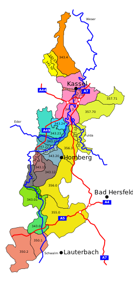
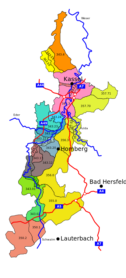
English: Map of macrochore "westhessian dip" a geological entity in Hesse, Germany
Deutsch: Karte der "westhessischen Senke" ein Naturraum in Hessen, Deutschland |
| Date | |
| Source | Own work |
| Author | Markus Schulenburg |
| Other versions |
 |
Licensing
I, the copyright holder of this work, hereby publish it under the following licenses:

|
Permission is granted to copy, distribute and/or modify this document under the terms of the GNU Free Documentation License, Version 1.2 or any later version published by the Free Software Foundation; with no Invariant Sections, no Front-Cover Texts, and no Back-Cover Texts. A copy of the license is included in the section entitled GNU Free Documentation License. |
This file is licensed under the Creative Commons Attribution-Share Alike 3.0 Unported license.
- You are free:
- to share – to copy, distribute and transmit the work
- to remix – to adapt the work
- Under the following conditions:
- attribution – You must give appropriate credit, provide a link to the license, and indicate if changes were made. You may do so in any reasonable manner, but not in any way that suggests the licensor endorses you or your use.
- share alike – If you remix, transform, or build upon the material, you must distribute your contributions under the same or compatible license as the original.
You may select the license of your choice.
File history
Click on a date/time to view the file as it appeared at that time.
| Date/Time | Thumbnail | Dimensions | User | Comment | |
|---|---|---|---|---|---|
| current | 18:12, 1 June 2009 | | 414 × 912 (126 KB) | Markus Schulenburg | Darstellungsprobleme hoffentlich beseitigt |
| 12:07, 1 June 2009 |  | 414 × 912 (127 KB) | Markus Schulenburg | Fehler beseitigt | |
| 12:00, 1 June 2009 |  | 414 × 912 (125 KB) | Markus Schulenburg | Angrenzende Untereinheiten des Naturraumes 35 eingezeichnet | |
| 13:22, 24 November 2008 |  | 414 × 912 (94 KB) | Markus Schulenburg | {{Information |Description= |Source= |Date= |Author= |Permission= |other_versions= }} | |
| 13:12, 24 November 2008 |  | 414 × 912 (96 KB) | Markus Schulenburg | {{Information |Description={{en|1=Map of macrochore "westhessian dip" a geological entity in Hesse, Germany}} {{de|1=Karte der "westhessischen Senke" ein Naturraum in Hessen, Deutschland}} |Source=Eigenes Werk (own work) |Author=[[User:Markus Schulenburg| |
File usage
The following pages on the English Wikipedia use this file (pages on other projects are not listed):
Global file usage
The following other wikis use this file:
- Usage on bg.wikipedia.org
- Usage on de.wikipedia.org
- Usage on es.wikipedia.org
- Usage on fr.wikipedia.org
- Usage on www.wikidata.org