
Size of this preview: 373 × 598 pixels. Other resolutions: 149 × 240 pixels | 299 × 480 pixels | 478 × 768 pixels | 638 × 1,024 pixels | 2,250 × 3,610 pixels.
Original file (2,250 × 3,610 pixels, file size: 1.79 MB, MIME type: image/png)
| This is a file from the Wikimedia Commons. Information from its description page there is shown below. Commons is a freely licensed media file repository. You can help. |
| Description |
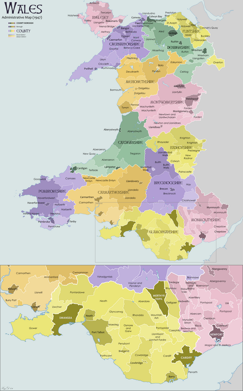
English: Map showing the administrative counties and other sub-divisions of Wales in 1947 |
| Date | |
| Source | Own work |
| Author | XrysD |
I, the copyright holder of this work, hereby publish it under the following license:

|
Permission is granted to copy, distribute and/or modify this document under the terms of the GNU Free Documentation License, Version 1.2 or any later version published by the Free Software Foundation; with no Invariant Sections, no Front-Cover Texts, and no Back-Cover Texts. A copy of the license is included in the section entitled GNU Free Documentation License. |
File history
Click on a date/time to view the file as it appeared at that time.
| Date/Time | Thumbnail | Dimensions | User | Comment | |
|---|---|---|---|---|---|
| current | 09:48, 10 November 2012 | | 2,250 × 3,610 (1.79 MB) | XrysD | Fixed typo, Bethseda->Bethesda |
| 21:37, 22 February 2010 |  | 2,250 × 3,610 (1.79 MB) | XrysD | Moved St Asaph from Denbigh to Flint. | |
| 19:15, 31 October 2009 |  | 2,250 × 3,610 (1.8 MB) | XrysD | {{Information |Description={{en|1=Map showing the administrative counties and other sub-divisions of Wales in 1947}} |Source={{own}} |Author=XrysD |Date=2009-10-31 |Permission= |other_versions= }} {{self|GFDL}} |
File usage
The following pages on the English Wikipedia use this file (pages on other projects are not listed):
- 1934 United Kingdom local elections
- 1949 United Kingdom local elections
- 1955 United Kingdom local elections
- Ammanford Urban District Council
- Burry Port Urban District
- Carmarthen Borough Council
- Carmarthen Rural District
- Carmarthenshire County Council, 1889–1974
- History of local government in Wales
- List of rural and urban districts in Wales in 1973
- Llandeilo Rural District
- Llandeilo Urban District
- Whitland Rural District
- Template:Carmarthenshire Pre-1974
Global file usage
The following other wikis use this file:
- Usage on cy.wikipedia.org
- Usage on uz.wikipedia.org
- Usage on zh.wikipedia.org