
Size of this preview: 800 × 554 pixels. Other resolutions: 320 × 222 pixels | 640 × 443 pixels | 969 × 671 pixels.
Original file (969 × 671 pixels, file size: 32 KB, MIME type: image/png)
| This is a file from the Wikimedia Commons. Information from its description page there is shown below. Commons is a freely licensed media file repository. You can help. |
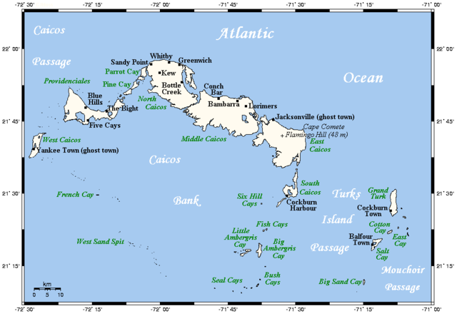
| Description | A map showing the Turks and Caicos Islands' main towns and islands. This map's source is here, with the uploader's modifications, and the GMT homepage says that the tools are released under the GNU General Public License. | ||||||||
| Date | |||||||||
| Source | Originally uploaded by Kelisi to en:Wikipedia (log). | ||||||||
| Author | Kelisi (talk) | ||||||||
| Permission (Reusing this file) |
Kelisi at the English language Wikipedia, the copyright holder of this work, hereby publishes it under the following license:
|

File history
Click on a date/time to view the file as it appeared at that time.
| Date/Time | Thumbnail | Dimensions | User | Comment | |
|---|---|---|---|---|---|
| current | 21:46, 4 April 2021 | | 969 × 671 (32 KB) | Kelisi | Newly discovered fact |
| 10:27, 21 December 2009 |  | 969 × 671 (25 KB) | Xfigpower | {{Information |Description=A map showing the Turks and Caicos Islands' main towns and islands. This map's source is [http://www.aquarius.ifm-geomar.de/ here], with the uploader's modifications, and the [http://gmt.soest.hawaii.edu/ GMT homepage] says that |
File usage
The following pages on the English Wikipedia use this file (pages on other projects are not listed):
Global file usage
The following other wikis use this file:
- Usage on af.wikipedia.org
- Usage on als.wikipedia.org
- Usage on ar.wikipedia.org
- Usage on br.wikipedia.org
- Usage on bs.wikipedia.org
- Usage on en.wiktionary.org
- Usage on es.wikipedia.org
- Usage on fa.wikipedia.org
- Usage on hr.wikipedia.org
- Usage on id.wikipedia.org
- Usage on it.wikipedia.org
- Usage on ja.wikipedia.org
- Usage on ln.wikipedia.org
- Usage on lt.wikipedia.org
- Usage on mk.wikipedia.org
- Usage on pt.wikipedia.org
- Usage on ru.wikipedia.org
- Usage on sh.wikipedia.org
- Usage on simple.wikipedia.org
- Usage on sk.wikipedia.org
- Usage on uk.wikipedia.org
- Usage on vi.wikipedia.org
- Usage on zh.wikipedia.org