Size of this preview: 800 × 570 pixels. Other resolutions: 320 × 228 pixels | 640 × 456 pixels | 1,024 × 729 pixels | 1,280 × 912 pixels | 2,560 × 1,823 pixels | 4,403 × 3,136 pixels.
Original file (4,403 × 3,136 pixels, file size: 12.26 MB, MIME type: image/png)
| This is a file from the Wikimedia Commons. Information from its description page there is shown below. Commons is a freely licensed media file repository. You can help. |
Summary
| Description |
|
| Date | see file history |
| Source | Own work using: OpenStreetMap Data for the background |
| Author | Maximilian Dörrbecker (Chumwa) |
| Permission (Reusing this file) |
I, the copyright holder of this work, hereby publish it under the following license: This file is licensed under the Creative Commons Attribution-Share Alike 2.5 Generic license.
Sie dürfen das Bild zu den folgenden Bedingungen nutzen:
|
File history
Click on a date/time to view the file as it appeared at that time.
| Date/Time | Thumbnail | Dimensions | User | Comment | |
|---|---|---|---|---|---|
| current | 19:18, 12 June 2019 | | 4,403 × 3,136 (12.26 MB) | Chumwa | |
| 22:04, 11 June 2019 |  | 4,403 × 3,136 (12.26 MB) | Chumwa | ||
| 22:49, 10 June 2019 |  | 4,403 × 3,136 (12.25 MB) | Chumwa | ||
| 18:21, 10 June 2019 |  | 4,403 × 3,136 (12.09 MB) | Chumwa | ||
| 17:11, 10 June 2019 |  | 4,403 × 3,136 (12.1 MB) | Chumwa | ||
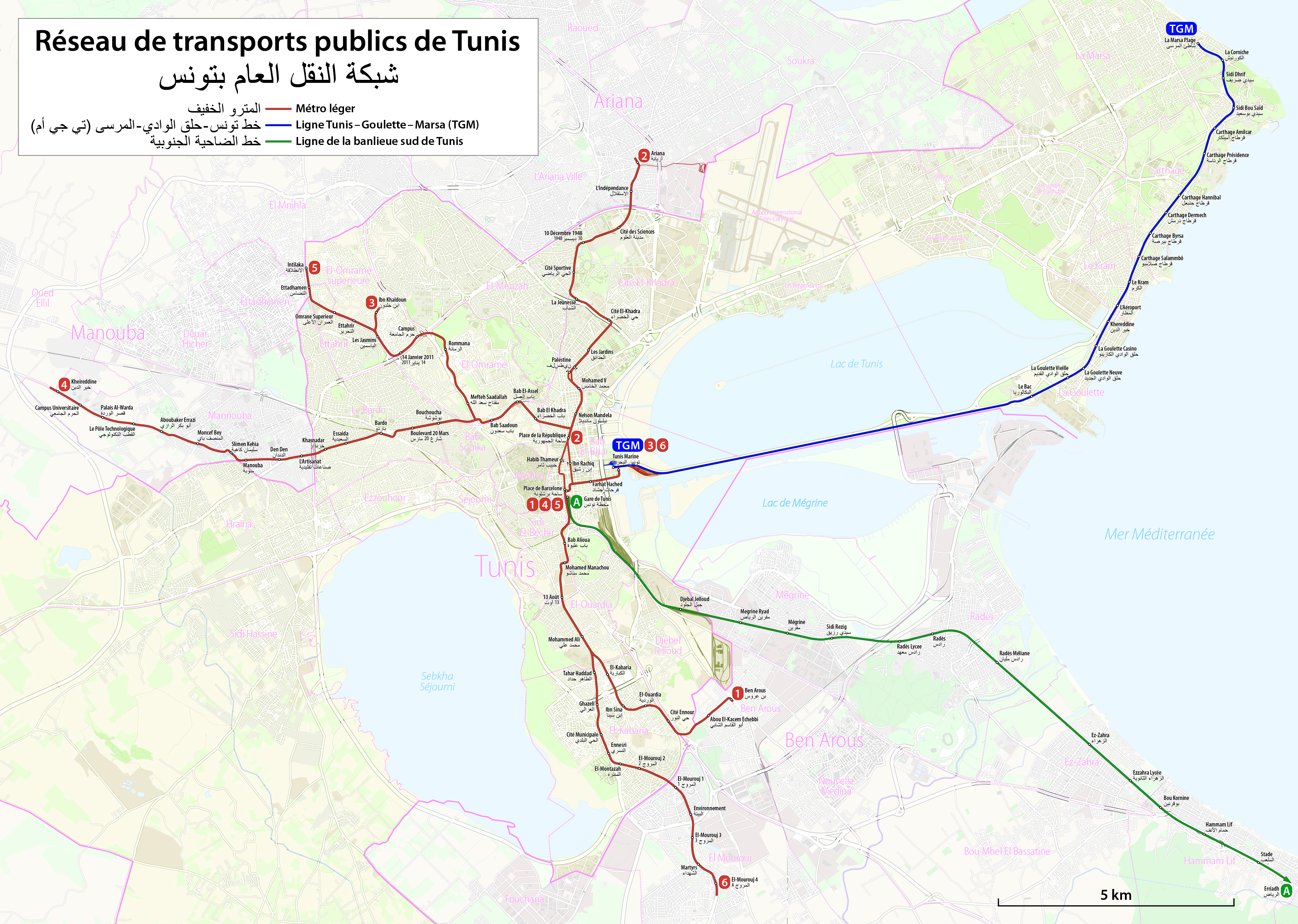
| 15:11, 10 June 2019 |  | 4,403 × 3,136 (12.13 MB) | Chumwa | == {{int:filedesc}} == {{Information |Description= *{{de|Schienennahverkehr in Tunis (Stadtbahn und Vorortzüge)}} *{{en|Tunis Rapid Transit Map (light rail and suburban trains)}} *{{fr|Réseau de transport public de Tunis (métro léger et RER)}} |Source={{own using}} OpenStreetMap Data for the background |Date=see file history |Author= Maximilian Dörrbecker (Chumwa) |Permission={{self|cc-by-sa-2.5}} Sie dürfen das Bild zu den folgenden Bedingungen nutzen... |
File usage
The following pages on the English Wikipedia use this file (pages on other projects are not listed):
Global file usage
The following other wikis use this file:
- Usage on ar.wikipedia.org
- Usage on ca.wikipedia.org
- Usage on de.wikipedia.org
- Usage on de.wikivoyage.org
- Usage on el.wikivoyage.org
- Usage on en.wikivoyage.org
- Usage on es.wikipedia.org
- Usage on fr.wikipedia.org
- Usage on fr.wikivoyage.org
- Usage on it.wikipedia.org
- Usage on it.wikivoyage.org
- Usage on ja.wikipedia.org
- Usage on nl.wikipedia.org
- Usage on pl.wikipedia.org
- Usage on pl.wikivoyage.org
- Usage on pt.wikipedia.org
- Usage on pt.wikivoyage.org
- Usage on ru.wikipedia.org
- Usage on th.wikipedia.org
- Usage on tr.wikipedia.org
- Usage on uk.wikipedia.org
- Usage on www.wikidata.org
- Usage on zh.wikipedia.org