
Size of this preview: 800 × 532 pixels. Other resolutions: 320 × 213 pixels | 640 × 426 pixels | 1,024 × 681 pixels | 1,280 × 851 pixels | 2,560 × 1,702 pixels | 6,016 × 4,000 pixels.
Original file (6,016 × 4,000 pixels, file size: 6.92 MB, MIME type: image/jpeg)
| This is a file from the Wikimedia Commons. Information from its description page there is shown below. Commons is a freely licensed media file repository. You can help. |
|
This is an image of a place or building that is listed on the National Register of Historic Places in the United States of America. Its reference number is 82004581. |
| Camera location | | View this and other nearby images on: OpenStreetMap |
|---|
| Description |
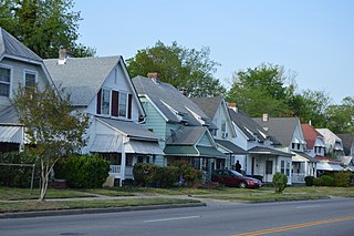
English: Houses on the northern side of Portsmouth Boulevard (State Route 337) west of the Dahlia Street intersection in Portsmouth, Virginia, United States. This block is part of the Truxtun Historic District, a historic district that is listed on the National Register of Historic Places. |
||
| Date | Taken on 15 April 2017 | ||
| Source | Own work | ||
| Author | Nyttend | ||
| Permission (Reusing this file) |
|
File history
Click on a date/time to view the file as it appeared at that time.
| Date/Time | Thumbnail | Dimensions | User | Comment | |
|---|---|---|---|---|---|
| current | 01:57, 7 May 2017 | | 6,016 × 4,000 (6.92 MB) | Nyttend | {{NRHP|82004581}} {{Location|36|48|59|N|76|19|57|W}} {{Information |Description={{en|Houses on the northern side of Portsmouth Boulevard ({{w|Virginia State Route 337|State Route 337}}) west of the Dahlia Street intersection in {{w|Portsmouth, Virginia... |
File usage
The following pages on the English Wikipedia use this file (pages on other projects are not listed):
Global file usage
The following other wikis use this file:
- Usage on ceb.wikipedia.org
- Usage on www.wikidata.org