Size of this preview: 800 × 539 pixels. Other resolutions: 320 × 216 pixels | 640 × 432 pixels | 1,024 × 690 pixels | 1,483 × 1,000 pixels.
Original file (1,483 × 1,000 pixels, file size: 215 KB, MIME type: image/jpeg)
| This is a file from the Wikimedia Commons. Information from its description page there is shown below. Commons is a freely licensed media file repository. You can help. |
| This is a featured picture, which means that members of the community have identified it as one of the finest images on the English Wikipedia, adding significantly to its accompanying article. If you have a different image of similar quality, be sure to upload it using the proper free license tag, add it to a relevant article, and nominate it. |
| This image was selected as picture of the day on the English Wikipedia for November 26, 2008. |
|
This is an image of a place or building that is listed on the National Register of Historic Places in the United States of America. Its reference number is 66000493. |
|
Summary
| Description |
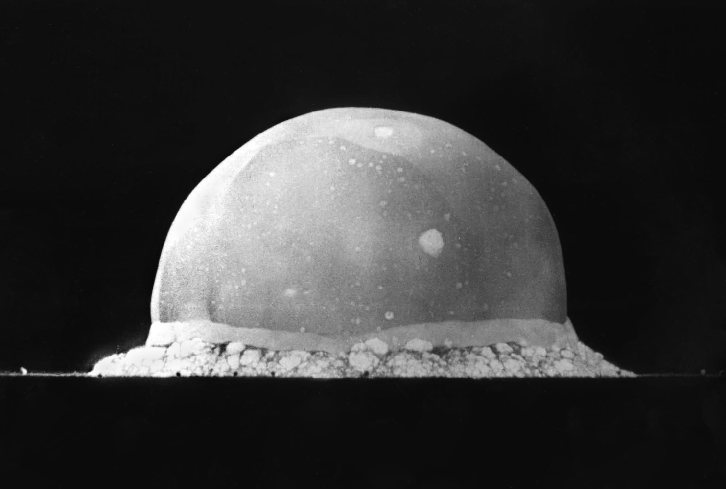
English: PA-98-0520 — Trinity Site explosion, 0.016 second after explosion, July 16, 1945. The viewed hemisphere's highest point in this image is about 200 meters high.
Türkçe: 16 Temmuz 1945 yılında New Mexico'daki Socorro'nın 56 km kadar güneydoğusunda şu an üzerinde komuta merkezi Alamogordo'da bulunan White Sands Missile Range'in bulunduğu yerde yapılmış Trinity patlamasının, infilak anından 0,016 sn sonra çekilmiş görüntüsüdür. Görüntülenen yarım kürenin en yüksek noktası yaklaşık 200 metre yüksekliğindedir.
Deutsch: Foto des Trinity-Tests, 16ms nach der Zündung am 16. Juli 1945. Die im Bild sichtbaren Feuerblase hat zu diesem Zeitpunkt eine Höhe von ca. 200 Metern. |
||||||
| Date | |||||||
| Source | http://www.lanl.gov/orgs/pa/photos/images/PA-98-0520.jpeg | ||||||
| Author | Berlyn Brixner / Los Alamos National Laboratory | ||||||
| Permission (Reusing this file) |
|
||||||

| Camera location | | View this and other nearby images on: OpenStreetMap |
|---|
File history
Click on a date/time to view the file as it appeared at that time.
| Date/Time | Thumbnail | Dimensions | User | Comment | |
|---|---|---|---|---|---|
| current | 02:13, 8 June 2008 | | 1,483 × 1,000 (215 KB) | File Upload Bot (Magnus Manske) | {{BotMoveToCommons|en.wikipedia}} {{Information |Description={{en|PA-98-0520 -- Trinity Site explosion, .016 seconds after explosion, July 16, 1945. :URL: http://www.lanl.gov/orgs/pa/photos/images/PA-98-0520.jpeg :Photo Credit: Los Alamos National Labora |
File usage
The following pages on the English Wikipedia use this file (pages on other projects are not listed):
- Anthropocene
- Berlyn Brixner
- History of the anti-nuclear movement
- Key events of the 20th century
- List of National Historic Landmarks in New Mexico
- List of states with nuclear weapons
- Los Alamos National Laboratory
- National Register of Historic Places listings in Socorro County, New Mexico
- New Mexico State Register of Cultural Properties
- White Sands Missile Range
- User:Daniel Mietchen/gallery
- User:DougieSC/J. Robert Oppenheimer
- User:Tillman
- User talk:Tillman
- Wikipedia:Featured picture candidates/May-2008
- Wikipedia:Featured picture candidates/The Trinity nuclear test, 1945
- Wikipedia:Featured pictures/History/USA History
- Wikipedia:Featured pictures thumbs/11
- Wikipedia:Picture of the day/November 2008
- Wikipedia:Picture peer review/Archives/Apr-Jun 2008
- Wikipedia:Picture peer review/Trinity explosion, 1945
- Wikipedia:Selected anniversaries/July 16
- Wikipedia:WikiProject Military history/Showcase
- Wikipedia:WikiProject Military history/Showcase/FP
- Wikipedia:WikiProject United States/Featured pictures
- Wikipedia:WikiProject United States/Quality content
- Wikipedia:WikiProject United States/Recognized content
- Wikipedia:WikiProject United States Government
- Wikipedia:WikiProject United States Government/Featured Content
- Wikipedia:Wikipedia Signpost/2008-06-02/Features and admins
- Wikipedia:Wikipedia Signpost/2008-06-02/SPV
- Wikipedia:Wikipedia Signpost/2015-02-25/Featured content
- Wikipedia:Wikipedia Signpost/Single/2008-06-02
- Wikipedia:Wikipedia Signpost/Single/2015-02-25
- Template:POTD/2008-11-26
- Portal:History/Featured picture
- Portal:History/Featured picture/3
- Portal:North America/Selected picture
- Portal:North America/Selected picture/53
- Portal:Technology/Selected anniversaries
- Portal:Technology/Selected anniversaries/July
- Portal:United States/Anniversaries/All
- Portal:United States/Anniversaries/July
- Portal:United States/Anniversaries/July/July 16
- Portal:United States/Selected picture
Global file usage
The following other wikis use this file:
- Usage on ab.wikipedia.org
- Usage on ar.wikipedia.org
- Usage on arz.wikipedia.org
- Usage on bcl.wikipedia.org
- Usage on be-tarask.wikipedia.org
- Usage on ca.wikipedia.org
- Usage on ce.wikipedia.org
- Usage on cs.wikipedia.org
- Usage on cv.wikipedia.org
- Usage on de.wikipedia.org
- Usage on el.wikipedia.org
- Usage on en.wikiquote.org
- Usage on en.wikiversity.org
- Usage on es.wikipedia.org
- Usage on fa.wikipedia.org
- ویکیپدیا:گزیدن نگاره برگزیده/اکتبر-۲۰۱۲
- درگاه:تاریخ/نگارهٔ برگزیده
- ویکیپدیا:گزیدن نگاره برگزیده/Trinity Test Fireball 16ms.jpg
- ویکیپدیا:نگاره روز/فوریه ۲۰۱۳
- الگو:نر/2013-02-03
- الگو:نر محافظت شده/2013-02-03
- درگاه:ایالات متحده آمریکا/نگاره برگزیده
- درگاه:ایالات متحده آمریکا/نگاره برگزیده/۱۰
- درگاه:تاریخ/نگارهٔ برگزیده/۱۶
- درگاه:فناوری هستهای/نگارهٔ برگزیده
- درگاه:فناوری هستهای/نگارهٔ برگزیده/۳
- ویکیپدیا:نگارههای برگزیده/تاریخی/جهان
- پیمان منع جامع آزمایش هستهای
- حوزه موشکی وایت سندز
- Usage on fi.wikipedia.org
View more global usage of this file.