
Size of this preview: 799 × 600 pixels. Other resolutions: 320 × 240 pixels | 640 × 480 pixels | 1,023 × 768 pixels | 1,280 × 961 pixels | 1,507 × 1,131 pixels.
Original file (1,507 × 1,131 pixels, file size: 336 KB, MIME type: image/png)
| This is a file from the Wikimedia Commons. Information from its description page there is shown below. Commons is a freely licensed media file repository. You can help. |
Summary
| Description |
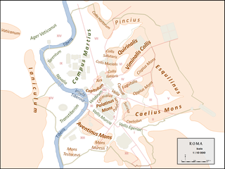
Français : Topographie simplifiée de la ville de Rome antique avec empreintes des principaux monuments et tracés des murs servien et aurélien. |
| Date | |
| Source | Own work |
| Author | Cassius Ahenobarbus |
Licensing
I, the copyright holder of this work, hereby publish it under the following license:
This file is licensed under the Creative Commons Attribution-Share Alike 4.0 International license.
- You are free:
- to share – to copy, distribute and transmit the work
- to remix – to adapt the work
- Under the following conditions:
- attribution – You must give appropriate credit, provide a link to the license, and indicate if changes were made. You may do so in any reasonable manner, but not in any way that suggests the licensor endorses you or your use.
- share alike – If you remix, transform, or build upon the material, you must distribute your contributions under the same or compatible license as the original.
File history
Click on a date/time to view the file as it appeared at that time.
| Date/Time | Thumbnail | Dimensions | User | Comment | |
|---|---|---|---|---|---|
| current | 13:55, 10 August 2015 | | 1,507 × 1,131 (336 KB) | Cassius Ahenobarbus | maj |
| 11:12, 23 July 2015 |  | 1,507 × 1,131 (333 KB) | Cassius Ahenobarbus | corr Fagutalis+Esquilinus | |
| 12:37, 22 July 2015 |  | 1,507 × 1,131 (333 KB) | Cassius Ahenobarbus | User created page with UploadWizard |
File usage
The following pages on the English Wikipedia use this file (pages on other projects are not listed):
Global file usage
The following other wikis use this file:
- Usage on ca.wikipedia.org
- Usage on el.wikipedia.org
- Usage on es.wikipedia.org
- Usage on frp.wikipedia.org
- Usage on fr.wikipedia.org
- Champ de Mars (Rome)
- Capitole
- Mont Palatin
- Aventin
- Sept collines de Rome
- Cælius
- Esquilin
- Quirinal
- Viminal
- Subure
- Oppius
- Janicule
- Vélabre
- Capitolium
- Colline de l'Arx
- Velia (Rome antique)
- Modèle:Palette Colline Vallee Rome
- Cispius
- Vallée de la Murcia
- Plaine vaticane
- Decennium
- Pincio
- Trastevere
- Mont Testaccio
- Asylum (Rome antique)
- Vatican (colline)
- Fagutal
- Utilisateur:Ruyblas13/Brouillon/Ruma étrusque
- Ruma étrusque
- Clivus Victoriae
- Usage on fr.wiktionary.org
- Usage on it.wikipedia.org
- Usage on nl.wikipedia.org
- Usage on no.wikipedia.org
- Usage on pl.wiktionary.org
- Usage on pt.wikipedia.org