No higher resolution available.
Tollhouse1155923.jpg (640 × 493 pixels, file size: 110 KB, MIME type: image/jpeg)
| This is a file from the Wikimedia Commons. Information from its description page there is shown below. Commons is a freely licensed media file repository. You can help. |
Summary
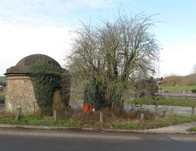
| Description |
English: Ashcombe Toll House. Curious relic from the age of the turnpike. Located at the original junction of the A27 and Ashcombe Hollow, the former has been moved few yards to the north the latter to the right has now been blocked off and a new route takes the lane down to Ashcombe Farm Roundabout. Originally there was a pair but the northern one has been lost to road widening. The existence of fireplaces within the structure has led some to believe this was the domestic part of the tollgate, the collection area having been lost over time. A door is on the northern side and there are two windows either side, the roof was originally bricked in a circular fashion but was stolen in the 1940s before East Sussex County Council restored it in the 1950s. The tollgate opened in 1820 and probably went into disuse when the turnpike was wound up in 1871, after that ownership became a little blurred and was claimed by Sussex Heritage Society in 1996 and has never been contested. See link for inside views [1] |
| Date | |
| Source | From geograph.org.uk |
| Author | Simon Carey |
| Permission (Reusing this file) |
Creative Commons Attribution Share-alike license 2.0 |
| Attribution (required by the license) | Simon Carey / Ashcombe Toll House / |
| Camera location | | View this and other nearby images on: OpenStreetMap |
|---|
Licensing

|
This image was taken from the Geograph project collection. See this photograph's page on the Geograph website for the photographer's contact details. The copyright on this image is owned by Simon Carey and is licensed for reuse under the Creative Commons Attribution-ShareAlike 2.0 license.
|
This file is licensed under the Creative Commons Attribution-Share Alike 2.0 Generic license.
Attribution: Simon Carey
- You are free:
- to share – to copy, distribute and transmit the work
- to remix – to adapt the work
- Under the following conditions:
- attribution – You must give appropriate credit, provide a link to the license, and indicate if changes were made. You may do so in any reasonable manner, but not in any way that suggests the licensor endorses you or your use.
- share alike – If you remix, transform, or build upon the material, you must distribute your contributions under the same or compatible license as the original.
File history
Click on a date/time to view the file as it appeared at that time.
| Date/Time | Thumbnail | Dimensions | User | Comment | |
|---|---|---|---|---|---|
| current | 11:23, 8 February 2011 | | 640 × 493 (110 KB) | Wilfridselsey | == {{int:filedesc}} == {{Information |Description={{en|1=Ashcombe Toll House}} |Source=From [http://www.geograph.org.uk/photo/1155923 geograph.org.uk] |Date=2009-02-08 |Author=[http://www.geograph.org.uk/profile/1833 Simon Carey] |Permission=Creative Comm |
File usage
The following pages on the English Wikipedia use this file (pages on other projects are not listed):