
No higher resolution available.
Thevmap.jpg (760 × 577 pixels, file size: 81 KB, MIME type: image/jpeg)
| This is a file from the Wikimedia Commons. Information from its description page there is shown below. Commons is a freely licensed media file repository. You can help. |
Summary
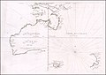
English: Melchesidech Thevenot's 1672 reprint of his 1663 reprint of Joan Blaeu's 1659 reprint of 1644 chart by Abel Tasman. Later copied by Emanuel Bowen in 1744, thought to have been used by w:James Cook. Tasman sailed north from w:New Zealand through the area marked Terre Australe. This image is from a copy held by the National Library of Australia. The image is in the public domain under both w:Australian copyright law and w:US copyright law.
-
 1663 version
 -
 B&W
B&W

_663_(ca._1672).jpg)
|
This work is in the public domain in its country of origin and other countries and areas where the copyright term is the author's life plus 100 years or fewer. | |
| This file has been identified as being free of known restrictions under copyright law, including all related and neighboring rights. | |
File history
Click on a date/time to view the file as it appeared at that time.
| Date/Time | Thumbnail | Dimensions | User | Comment | |
|---|---|---|---|---|---|
| current | 13:44, 26 November 2008 | | 760 × 577 (81 KB) | Moondyne | Cropped to remove NLA tagging |
| 15:55, 9 June 2005 |  | 760 × 592 (83 KB) | Moondyne | Joan Blaeu's map of 1659 after Jaszoon & Tasman's voyages of 1642 and 1643. As copied by the Frenchman Thevenot. This map was in turn copied by the Englishman Emmanuel Bowen in 1744 and thought to have been used by Cook. Tasman sailed north from New Zeala |
File usage
The following pages on the English Wikipedia use this file (pages on other projects are not listed):
Global file usage
The following other wikis use this file:
- Usage on ms.wikipedia.org