No higher resolution available.
TVA-sites-map.png (439 × 325 pixels, file size: 20 KB, MIME type: image/png)
| This is a file from the Wikimedia Commons. Information from its description page there is shown below. Commons is a freely licensed media file repository. You can help. |
Summary
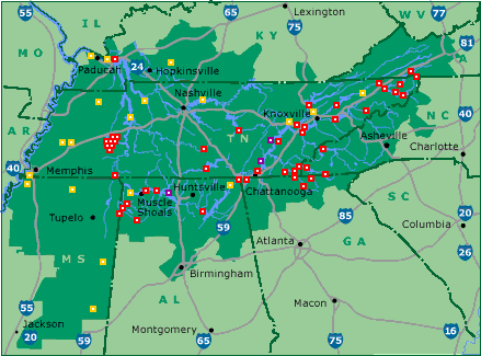
| Description | Map of Tennessee Valley Authority sites. Key: red: dam, magenta: nuclear power plant, orange: fossil-fuel plant |
| Source | tva.com |
| Author | Tennessee Valley Authority |
Licensing
| This image is a work of a United States Tennessee Valley Authority employee, taken or made as part of that person's official duties. As a work of the U.S. federal government, the image is in the public domain in the United States. |
Original upload log
(All user names refer to en.wikipedia)
- 2005-05-18 01:09 ChrisRuvolo 439×325×8 (19706 bytes) Map of [[Tennessee Valley Authority]] sites. Key: red: [[dam]], magenta: [[nuclear power plant]] orange: [[fossil fuel]] plant Source: [http://www.tva.gov/sites/sites_ie2.htm] [http://www.tva.gov/sites/images/sitesmap3.gif], converted to PNG {{PD-USG
File history
Click on a date/time to view the file as it appeared at that time.
| Date/Time | Thumbnail | Dimensions | User | Comment | |
|---|---|---|---|---|---|
| current | 10:03, 9 August 2015 | | 439 × 325 (20 KB) | Kopiersperre | png repaired |
| 11:49, 26 May 2007 |  | 439 × 325 (19 KB) | Kordas | {{Information |Description=Map of en:Tennessee Valley Authority sites. Key: red: en:dam, magenta: en:nuclear power plant orange: en:fossil fuel plant Source: [http://www.tva.gov/sites/sites_ie2.htm] [http://www.tva.gov/sites/images |
File usage
No pages on the English Wikipedia use this file (pages on other projects are not listed).
Global file usage
The following other wikis use this file:
- Usage on da.wikipedia.org
- Usage on es.wikipedia.org
- Usage on he.wikipedia.org
- Usage on nl.wikipedia.org
- Usage on no.wikipedia.org
- Usage on zh.wikipedia.org