No higher resolution available.
TTPI-locatormap.png (326 × 225 pixels, file size: 11 KB, MIME type: image/png)
| This is a file from the Wikimedia Commons. Information from its description page there is shown below. Commons is a freely licensed media file repository. You can help. |

|
This historical map image could be re-created using vector graphics as an SVG file. This has several advantages; see Commons:Media for cleanup for more information. If an SVG form of this image is available, please upload it and afterwards replace this template with
{{vector version available|new image name}}.
It is recommended to name the SVG file “TTPI-locatormap.svg”—then the template Vector version available (or Vva) does not need the new image name parameter. |
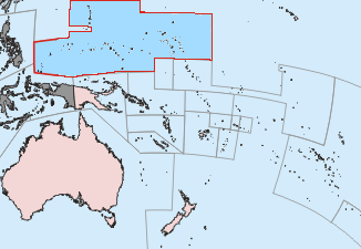
| Description |
Čeština: Mapa poručenského území Tichomořských ostrovů.
English: This is a locator map of the former Trust Territory of the Pacific Islands (TTPI). |
||||||||
| Source | The map is based off of a locator map of Palau found on the German Wiki at de:Bild:Palau-Pos.png; it was created by German Wiki user de:Benutzer:Tzzzpfffand licensed under the GFDL. The changes made from the original map are various. The current boundries of the CNMI, Palau, FSM, and RMI are merged and Guam has it's own boundary due to the fact it never was a part of the TTPI. Boundries have been compared with Image:MapofTTPI.gif for accuracy. As the orginial image was licensed under the GFDL, I place my modification of the orginial map under the GFDL as well. | ||||||||
| Author |
|
||||||||
| Permission (Reusing this file) |
|


File history
Click on a date/time to view the file as it appeared at that time.
| Date/Time | Thumbnail | Dimensions | User | Comment | |
|---|---|---|---|---|---|
| current | 01:27, 17 June 2010 | | 326 × 225 (11 KB) | Ras67 | cropped |
| 14:52, 19 November 2006 |  | 330 × 228 (14 KB) | Electionworld | == Summary == This is a locator map of the former Trust Territory of the Pacific Islands (TTPI). The map is based off of a locator map of Palau found on the German Wiki at de:Bild:Palau-Pos.png; it was created by German Wiki user [[:de:Benutzer:T |
File usage
The following pages on the English Wikipedia use this file (pages on other projects are not listed):
- Aftermath of World War II
- Decolonization
- High Commissioner of the Trust Territory of the Pacific Islands
- Japan–Oceania relations
- List of national border changes (1914–present)
- Trust Territory of the Pacific Islands
- Wikipedia:Graphics Lab/Map workshop/Archive/Oct 2010
- Wikipedia:Reference desk/Archives/Humanities/2020 June 23
Global file usage
The following other wikis use this file:
- Usage on ar.wikipedia.org
- Usage on ast.wikipedia.org
- Usage on azb.wikipedia.org
- Usage on az.wikipedia.org
- Usage on be.wikipedia.org
- Usage on bg.wikipedia.org
- Usage on ca.wikipedia.org
- Usage on cs.wikipedia.org
- Usage on da.wikipedia.org
- Usage on de.wikipedia.org
- Usage on eo.wikipedia.org
- Usage on es.wikipedia.org
- Usage on fa.wikipedia.org
- Usage on fi.wikipedia.org
- Usage on fr.wikipedia.org
- Usage on he.wikipedia.org
- Usage on hu.wikipedia.org
- Usage on hy.wikipedia.org
- Usage on ia.wikipedia.org
- Usage on id.wikipedia.org
- Usage on it.wikipedia.org
- Usage on ja.wikipedia.org
- Usage on ko.wikipedia.org
- Usage on lt.wikipedia.org
- Usage on mr.wikipedia.org
- Usage on nl.wikipedia.org
- Usage on no.wikipedia.org
- Usage on pl.wikipedia.org
View more global usage of this file.