No higher resolution available.
Sunset_crater_Landsat_2016.jpg (720 × 480 pixels, file size: 182 KB, MIME type: image/jpeg)
| This is a file from the Wikimedia Commons. Information from its description page there is shown below. Commons is a freely licensed media file repository. You can help. |
| Description |
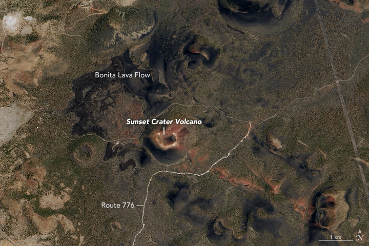
English: On July 12, 2016, the Operational Land Imager (OLI) on the Landsat 8 satellite captured a natural-color image (above) of the crater and the surrounding San Francisco Volcanic Field. The image was draped over terrain data from the Advanced Spaceborne Thermal Emission and Reflection Radiometer (ASTER). Note: the scene was rotated to create this image, so north is to the right. The closeup below shows Sunset Crater as observed by OLI, but without the terrain drape (north is up). To the east of the cone, a field of dark, hardened rock from the Bonita Lava Flow is still visible. |
|||||
| Date | acquired July 12, 2016 | |||||
| Source | https://earthobservatory.nasa.gov/IOTD/view.php?id=90413&src=eoa-iotd | |||||
| Author | NASA Earth Observatory images by Jesse Allen, using Landsat data from the U.S. Geological Survey | |||||
| Permission (Reusing this file) |
|

File history
Click on a date/time to view the file as it appeared at that time.
| Date/Time | Thumbnail | Dimensions | User | Comment | |
|---|---|---|---|---|---|
| current | 15:42, 26 July 2017 | | 720 × 480 (182 KB) | Tillman | {{Information |Description ={{en|1=On July 12, 2016, the Operational Land Imager (OLI) on the Landsat 8 satellite captured a natural-color image (above) of the crater and the surrounding San Francisco Volcanic Field. The image was draped over terrai... |
File usage
No pages on the English Wikipedia use this file (pages on other projects are not listed).
Global file usage
The following other wikis use this file:
- Usage on zh.wikipedia.org