
Size of this preview: 800 × 532 pixels. Other resolutions: 320 × 213 pixels | 640 × 426 pixels | 1,024 × 681 pixels | 1,280 × 851 pixels | 2,560 × 1,702 pixels | 6,016 × 4,000 pixels.
Original file (6,016 × 4,000 pixels, file size: 6.27 MB, MIME type: image/jpeg)
| This is a file from the Wikimedia Commons. Information from its description page there is shown below. Commons is a freely licensed media file repository. You can help. |
|
This is an image of a place or building that is listed on the National Register of Historic Places in the United States of America. Its reference number is 100004259. |
| Camera location | | View this and other nearby images on: OpenStreetMap |
|---|
| Description |
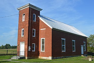
English: Front and southern side of Stone's Chapel, located at 4138 Crums Church Road southeast of Wadesville in Clarke County, Virginia, United States. Built in 1849, it is listed on the National Register of Historic Places. |
||
| Date | Taken on 31 August 2019 | ||
| Source | Self-photographed | ||
| Author | Nyttend | ||
| Permission (Reusing this file) |
|
||
| Other versions | None |
File history
Click on a date/time to view the file as it appeared at that time.
| Date/Time | Thumbnail | Dimensions | User | Comment | |
|---|---|---|---|---|---|
| current | 16:28, 26 February 2020 | | 6,016 × 4,000 (6.27 MB) | Nyttend |
File usage
The following pages on the English Wikipedia use this file (pages on other projects are not listed):