File:Staatkundige kaart Groningen en Ommelanden.png

Original file(1,656 × 1,512 pixels, file size: 791 KB, MIME type: image/png)

Summary

Description
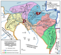
English: Map of the constitution of Groningen and the Ommelanden before 1795 (French invasion of the Netherlands), depicting the internal borders of the districts and subdistricts, indications of the borders of the former Reiderland, the most notable towns and water ways in the 17th and 18th century, the coastline of the Dollard in 1520 (largest extent), and indicates in text some important historical constitutional events.
Nederlands: Staatkundige kaart van Groningen en Ommelanden voor 1795 (Franse inval van de Nederlanden), met daarop afgebeeld de interne grenzen van de kwartieren en onderkwartieren, indicatie van de grenzen van het voormalige Reiderland, de belangrijkste plaatsen en waterwegen in de 17e en 18e eeuw, de kustlijn van de Dollard in 1520 (grootste omvang), en geeft in tekst belangrijke historische staatkundige gebeurtenissen weer.
Nedersaksies: Stoatkundege koarte van Grönnen en Ommelanden veur 1795 (Fraanse ienval van de Nederlanden), doar binnengruppen van de kertaaieren en onderkertaaieren op taikend binnen, liek as hou of gruppen van t eerdere Reiderlaand der oet zag, de veurnoamste ploatsen en wotterwegen ien 17e en 18e aiw, de kustlien van Dollert ien 1520 (grootste omvang), en gef ien tekst belaangrieke historische stoatkundege gebeurtenizzen weer.
Deutsch: Verwaltungskarte von Groningen und Ommelanden vor dem Jahr 1795 (französische Invasion der Niederlanden), auf welche die interne Grenzen der Bezirken und Unterbezirken abgebildet sind, wie auch eine Indikation der Grenzen des ehemaligen Rheiderlandes, die wichtigste Orte und Wasserwege im 17. und 18. Jahrhundert, die Küstlinie der Dollart im Jahr 1520 (größeste Umvang), und zeigt in Text einige wichtige historische politische Ereignisse.
Date
Source Own work
Author NLBerendsen

Licensing

I, the copyright holder of this work, hereby publish it under the following license:
w:en:Creative Commons
attribution share alike
This file is licensed under the Creative Commons Attribution-Share Alike 4.0 International license.
You are free:
  • to share – to copy, distribute and transmit the work
  • to remix – to adapt the work
Under the following conditions:
  • attribution – You must give appropriate credit, provide a link to the license, and indicate if changes were made. You may do so in any reasonable manner, but not in any way that suggests the licensor endorses you or your use.
  • share alike – If you remix, transform, or build upon the material, you must distribute your contributions under the same or compatible license as the original.

Captions

Add a one-line explanation of what this file represents

Items portrayed in this file

depicts

19 October 2018

File history

Click on a date/time to view the file as it appeared at that time.

Date/TimeThumbnailDimensionsUserComment
current09:25, 30 October 2018Thumbnail for version as of 09:25, 30 October 20181,656 × 1,512 (791 KB)NLBerendsenTypo Spanse > Spaanse
00:12, 20 October 2018Thumbnail for version as of 00:12, 20 October 20181,656 × 1,512 (790 KB)NLBerendsenMinor corrections
00:05, 20 October 2018Thumbnail for version as of 00:05, 20 October 20181,656 × 1,512 (790 KB)NLBerendsenUser created page with UploadWizard
The following pages on the English Wikipedia use this file (pages on other projects are not listed):

Global file usage

Metadata