
Size of this preview: 545 × 599 pixels. Other resolutions: 218 × 240 pixels | 436 × 480 pixels | 971 × 1,068 pixels.
Original file (971 × 1,068 pixels, file size: 296 KB, MIME type: image/png)
| This is a file from the Wikimedia Commons. Information from its description page there is shown below. Commons is a freely licensed media file repository. You can help. |
Summary
| Description |
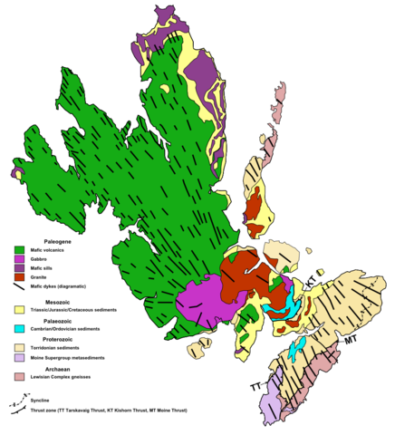
English: Geological map of Skye with information from British Geological Survey Geology of Britain viewer, Skye a landscape fashioned by Geology, Potts 1990, Blenkinsop & Rutter 1986 and Evans et al. 2009. |
| Date | |
| Source | Own work |
| Author | Mikenorton |
Licensing
I, the copyright holder of this work, hereby publish it under the following license:
This file is licensed under the Creative Commons Attribution-Share Alike 3.0 Unported license.
- You are free:
- to share – to copy, distribute and transmit the work
- to remix – to adapt the work
- Under the following conditions:
- attribution – You must give appropriate credit, provide a link to the license, and indicate if changes were made. You may do so in any reasonable manner, but not in any way that suggests the licensor endorses you or your use.
- share alike – If you remix, transform, or build upon the material, you must distribute your contributions under the same or compatible license as the original.
File history
Click on a date/time to view the file as it appeared at that time.
| Date/Time | Thumbnail | Dimensions | User | Comment | |
|---|---|---|---|---|---|
| current | 21:31, 13 January 2013 | | 971 × 1,068 (296 KB) | Mikenorton | Added the Tarskavaig thrust from Blenkinsop & Rutter 1986 - labelled all the thrusts |
| 13:51, 13 January 2013 |  | 971 × 1,068 (287 KB) | Mikenorton | Added some extra Moine outcrops and fixed line thickness | |
| 11:38, 13 January 2013 |  | 971 × 1,068 (287 KB) | Mikenorton | User created page with UploadWizard |
File usage
The following pages on the English Wikipedia use this file (pages on other projects are not listed):