
Size of this PNG preview of this SVG file: 800 × 533 pixels. Other resolutions: 320 × 213 pixels | 640 × 427 pixels | 1,024 × 683 pixels | 1,280 × 853 pixels | 2,560 × 1,707 pixels | 5,208 × 3,472 pixels.
Original file (SVG file, nominally 5,208 × 3,472 pixels, file size: 6.7 MB)
| This is a file from the Wikimedia Commons. Information from its description page there is shown below. Commons is a freely licensed media file repository. You can help. |
Summary
| Description |
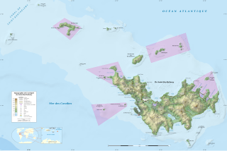
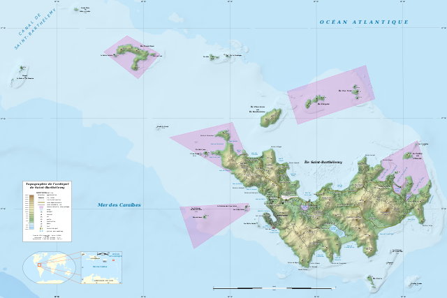
English: Topographic map in French of the Caribbean archipelago of Saint Barthélemy.
Note: the shaded relief is a raster image embedded in the SVG file. Français : Carte topographique en français de l'archipel de Saint-Barthélemy dans les Petites Antilles. Notes : le relief ombré est une image bitmap embarquée dans le fichier SVG.
|
||
| Date | 2010-07, updated 2024-01 | ||
| Source |
Own work
|
||
| Author | Eric Gaba (Sting - fr:Sting) | ||
| Permission (Reusing this file) |
|
||
| Other versions |
|


| Camera location | | View this and other nearby images on: OpenStreetMap |
|---|

|
This SVG file contains embedded text that can be translated into your language, using any capable SVG editor, text editor or the SVG Translate tool. For more information see: About translating SVG files. |
Licensing
Eric Gaba (Wikimedia Commons user Sting), the copyright holder of this work, hereby publishes it under the following license:
This file is licensed under the Creative Commons Attribution-Share Alike 4.0 International license.
Attribution: Eric Gaba (Wikimedia Commons user Sting)
- You are free:
- to share – to copy, distribute and transmit the work
- to remix – to adapt the work
- Under the following conditions:
- attribution – You must give appropriate credit, provide a link to the license, and indicate if changes were made. You may do so in any reasonable manner, but not in any way that suggests the licensor endorses you or your use.
- share alike – If you remix, transform, or build upon the material, you must distribute your contributions under the same or compatible license as the original.
File history
Click on a date/time to view the file as it appeared at that time.
| Date/Time | Thumbnail | Dimensions | User | Comment | |
|---|---|---|---|---|---|
| current | 01:55, 26 January 2024 | | 5,208 × 3,472 (6.7 MB) | Sting | Completely new map using updated data; same geographic limits as previous version |
| 23:43, 17 October 2015 |  | 2,430 × 1,620 (848 KB) | Sting | Using NASA SRTM 1 topographic data | |
| 19:00, 29 July 2010 |  | 2,430 × 1,620 (815 KB) | Sting | {== {{int:filedesc}} == {{Location|17|55|00|N|62|52|00|W|scale:50000}} <br/> {{Information |Description={{en|Topographic map in French of the Caribbean archipelago of Saint Barthélemy.<br/> ''Note: the shaded relief is a raster |
File usage
The following pages on the English Wikipedia use this file (pages on other projects are not listed):
Global file usage
The following other wikis use this file:
- Usage on af.wikipedia.org
- Usage on ar.wikipedia.org
- Usage on ast.wikipedia.org
- Usage on bs.wikipedia.org
- Usage on de.wikipedia.org
- Usage on eo.wikipedia.org
- Usage on es.wikipedia.org
- Usage on eu.wikipedia.org
- Usage on fa.wikipedia.org
- Usage on fr.wikipedia.org
- Usage on gl.wikipedia.org
- Usage on hu.wikipedia.org
- Usage on id.wikipedia.org
- Usage on incubator.wikimedia.org
- Usage on it.wikipedia.org
- Usage on kk.wikipedia.org
- Usage on lt.wikipedia.org
- Usage on nl.wikipedia.org
- Usage on pl.wikipedia.org
- Usage on ru.wikipedia.org
- Usage on sv.wikipedia.org
- Usage on ta.wikipedia.org
- Usage on th.wikipedia.org
- Usage on to.wikipedia.org
- Usage on uk.wikipedia.org
- Usage on ur.wikipedia.org
- Usage on uz.wikipedia.org
- Usage on vi.wikipedia.org
- Usage on www.wikidata.org