File:Ricketts Glen Lakes 1939 labels.PNG

Original file(1,832 × 1,830 pixels, file size: 4 MB, MIME type: image/png)

Summary

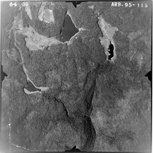
Description Aerial photo from 1939 of the lakes in w:Ricketts Glen State Park in Sullivan and Luzerne Counties, Pennsylvania in the United States. Pennsylvania Route 487 is the highway running vertically along the left side of the image. North is up. Lakes are Lake Jean (top left), Mud Pond (top center, now part of a larger Lake Jean), Lake Leigh (top right, drained in 1956) and Lake Rose (middle left, drained in 1969). Lake Rose drains into Ganoga Glen and Lake Leigh drains into Glen Leigh, these valleys meet at Waters Meet and Ricketts Glen is south and downstream of that).
Date Taken on 4 June 1939
Source File is here at the Penn Pilot website, "a project sponsored by the Pennsylvania Geological Survey, is an online library of digital historical aerial photography for the Commonwealth of Pennsylvania." Original file name was "lycoming_050659_aqe_4w_57.jpg"
Author According to this, "The photos were produced by the United States Department of Agriculture, Agricultural Adjustment Administration (now known as the Farm Service Agency)." Labels added by Ruhrfisch (talk)
Permission
(Reusing this file)
Public domain
This image or file is a work of a United States Department of Agriculture employee, taken or made as part of that person's official duties. As a work of the U.S. federal government, the image is in the public domain.

English  español  Nederlands  slovenščina  Tiếng Việt  македонски  русский  українська  日本語  +/−

Other versions
no labels

Licensing

Public domain
This image or file is a work of a United States Department of Agriculture employee, taken or made as part of that person's official duties. As a work of the U.S. federal government, the image is in the public domain.

English  español  Nederlands  slovenščina  Tiếng Việt  македонски  русский  українська  日本語  +/−

Captions

Add a one-line explanation of what this file represents

Items portrayed in this file

depicts

4 June 1939

File history

Click on a date/time to view the file as it appeared at that time.

Date/TimeThumbnailDimensionsUserComment
current18:52, 4 February 2010Thumbnail for version as of 18:52, 4 February 20101,832 × 1,830 (4 MB)Ruhrfisch== {{int:filedesc}} == {{Information |Description= Aerial photo from 1939 of the lakes in w:Ricketts Glen State Park in Sullivan and Luzerne Counties, Pennsylvania in the United States. Pennsylvania Route 487 is the highway running vertically along th
The following pages on the English Wikipedia use this file (pages on other projects are not listed):