No higher resolution available.
Remote_Country_-_geograph.org.uk_-_120032.jpg (640 × 427 pixels, file size: 86 KB, MIME type: image/jpeg)
| This is a file from the Wikimedia Commons. Information from its description page there is shown below. Commons is a freely licensed media file repository. You can help. |
Summary
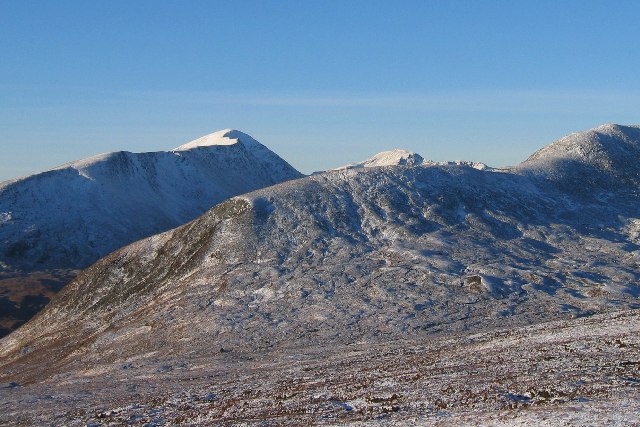
| Description |
English: Remote Country. Out of grid shot! This grid square is the ground from the bottom of the glen to the second rise in the immediate ridge.
The Magnificent looking hill in the back ground is the very remote Munro "Bidein a' Choire Sheasgaich". Note added by w:User:Thincat: Bidein a' Choire Sheasgaich is, in fact, the peak slightly right of centre and only just appearing above the near ridge. The snowy ridge to the left winds up to the more prominent peak of Lurg Mhor, somewhat left of centre. |
| Date | |
| Source | From geograph.org.uk |
| Author | Stuart Meek |
| Camera location | | View this and other nearby images on: OpenStreetMap |
|---|
_&language=en)
Licensing

|
This image was taken from the Geograph project collection. See this photograph's page on the Geograph website for the photographer's contact details. The copyright on this image is owned by Stuart Meek and is licensed for reuse under the Creative Commons Attribution-ShareAlike 2.0 license.
|
This file is licensed under the Creative Commons Attribution-Share Alike 2.0 Generic license.
Attribution: Stuart Meek
- You are free:
- to share – to copy, distribute and transmit the work
- to remix – to adapt the work
- Under the following conditions:
- attribution – You must give appropriate credit, provide a link to the license, and indicate if changes were made. You may do so in any reasonable manner, but not in any way that suggests the licensor endorses you or your use.
- share alike – If you remix, transform, or build upon the material, you must distribute your contributions under the same or compatible license as the original.
File history
Click on a date/time to view the file as it appeared at that time.
| Date/Time | Thumbnail | Dimensions | User | Comment | |
|---|---|---|---|---|---|
| current | 04:24, 31 January 2010 | | 640 × 427 (86 KB) | GeographBot | == {{int:filedesc}} == {{Information |description={{en|1=Remote Country. Out of grid shot! This grid square is the ground from the bottom of the glen to the second rise in the immediate ridge. The Magnificent looking hill in the back ground is the very r |
File usage
The following pages on the English Wikipedia use this file (pages on other projects are not listed):