.png)
.png&action=edit&redlink=1)
No higher resolution available.
Provinces_of_South_Korea_(numbered_map).png (520 × 600 pixels, file size: 82 KB, MIME type: image/png)
Summary edit
.png&action=edit§ion=1)
| Description |
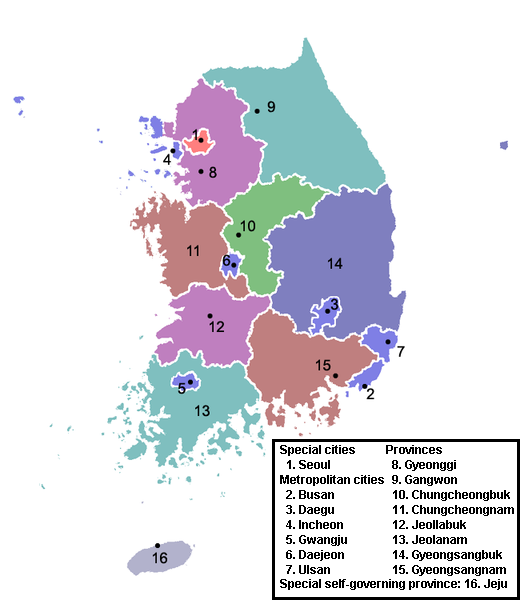
Provincial divisions of South Korea since partition. | ||
|---|---|---|---|
| Source |
Copied from ja:画像:韓国行政区域地図.png, originally uploaded by ja:利用者:Kahusi (also registered here: User:Kahusi) Modified by ArnoldPlaton | ||
| Date | |||
| Author |
| ||
| Permission (Reusing this file) |
See below.
|
Licensing edit
.png&action=edit§ion=2)
 | Permission is granted to copy, distribute and/or modify this document under the terms of the GNU Free Documentation License, Version 1.2 or any later version published by the Free Software Foundation; with no Invariant Sections, no Front-Cover Texts, and no Back-Cover Texts. |
| This work is licensed under the Creative Commons Attribution-ShareAlike 3.0 License. This licensing tag was added to this file as part of the GFDL licensing update. |
File history
Click on a date/time to view the file as it appeared at that time.
| Date/Time | Thumbnail | Dimensions | User | Comment | |
|---|---|---|---|---|---|
| current | 15:41, 31 August 2007 | | 520 × 600 (82 KB) | ArnoldPlaton (talk | contribs) | Copied from ja:画像:韓国行政区域地図.png, originally uploaded by ja:利用者:Kahusi (also registered here: User:Kahusi) Modified by ArnoldPlaton |
You cannot overwrite this file.
File usage
The following pages on the English Wikipedia use this file (pages on other projects are not listed):
.png&oldid=692611846)