
Original file (SVG file, nominally 612 × 1,173 pixels, file size: 211 KB)
| This is a file from the Wikimedia Commons. Information from its description page there is shown below. Commons is a freely licensed media file repository. You can help. |
Oi a cidade de Vizeu .
Summary
| Description |
Deutsch: Positionskarte von Portugal
Quadratische Plattkarte, N-S-Streckung 130 %. Geographische Begrenzung der Karte:
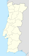
English: Location map of Portugal
Equirectangular projection, N/S stretching 130 %. Geographic limits of the map:
Español: Mapa de Portugal con los 18 distritos delimitados
Proyección cilíndrica equidistante, N/S alargamiento 130 %. Límites geográficos del mapa:
Português: Mapa de Portugal com os 18 distritos delimitados, para uso em localizações geográficas
Projecção cilíndrica equidistante, N/S alongamento 130 %. Limites geográficos do mapa:
|
| Date | 03-07-2008 |
| Source | own work, using United States National Imagery and Mapping Agency data |
| Author | NordNordWest |
| Other versions |
Derivative works of this file: |

|
This map has been made or improved in the German Kartenwerkstatt (Map Lab). You can propose maps to improve as well.
|
Licensing

|
Permission is granted to copy, distribute and/or modify this document under the terms of the GNU Free Documentation License, Version 1.2 or any later version published by the Free Software Foundation; with no Invariant Sections, no Front-Cover Texts, and no Back-Cover Texts. A copy of the license is included in the section entitled GNU Free Documentation License. |
- You are free:
- to share – to copy, distribute and transmit the work
- to remix – to adapt the work
- Under the following conditions:
- attribution – You must give appropriate credit, provide a link to the license, and indicate if changes were made. You may do so in any reasonable manner, but not in any way that suggests the licensor endorses you or your use.
- share alike – If you remix, transform, or build upon the material, you must distribute your contributions under the same or compatible license as the original.
File history
Click on a date/time to view the file as it appeared at that time.
| Date/Time | Thumbnail | Dimensions | User | Comment | |
|---|---|---|---|---|---|
| current | 08:27, 29 August 2008 | | 612 × 1,173 (211 KB) | NordNordWest | |
| 18:29, 11 August 2008 |  | 306 × 586 (207 KB) | NordNordWest | ||
| 22:01, 2 July 2008 |  | 306 × 586 (236 KB) | NordNordWest | {{Information |Description= {{de|Positionskarte von Portugal}} Quadratische Plattkarte, N-S-Streckung 130 %. Geographische Begrenzung der Karte: * N: 42.3° N * S: 36.7° N * W: 9.8° W * O: 6.0° W {{en|Location map of [[:en:Portugal|Por |
File usage
More than 100 pages use this file. The following list shows the first 100 pages that use this file only. A full list is available.
- A dos Francos
- Afife
- Aljubarrota
- Alvorninha
- Areias (Barcelos)
- Aveiras de Cima
- Aveleda (Bragança)
- Aveleda e Rio de Onor
- Aves (Santo Tirso)
- Babe (Bragança)
- Baçal
- Belver (Gavião)
- Benfica do Ribatejo
- Buarcos
- Burgães
- Caldas da Rainha — Santo Onofre e Serra do Bouro
- Camarate
- Carnaxide
- Carrazedo (Amares)
- Carregado
- Carreira (Santo Tirso)
- Carvalhal Benfeito
- Castrelos e Carrazedo
- Castro de Avelãs
- Cete, Portugal
- Coelhoso
- Comenda (Gavião)
- Couto (Santa Cristina)
- Couto (São Miguel)
- Donai
- Ericeira
- Esgueira
- Esmoriz
- Espinhosela
- Estoril
- Famalicão (Guarda)
- Famalicão (Nazaré)
- Foz do Arelho
- França (Bragança)
- Fátima, Portugal
- Gavião e Atalaia
- Gimonde
- Gondesende
- Gostei
- Grijó de Parada
- Guimarei
- Izeda, Calvelhe e Paradinha Nova
- Jewish philosophy
- Landal
- Lisbon Airport
- List of presidents of Portugal
- Loriga
- Macedo do Mato
- Margem
- Massamá
- Mira de Aire
- Monte Córdova
- Mós (Bragança)
- Nadadouro
- Nogueira (Bragança)
- Nossa Senhora do Pópulo
- Outeiro (Bragança)
- Parada e Failde
- Paradinha
- Parâmio
- Pinela
- Pinhal Novo
- Primeira Liga
- Póvoa de Varzim
- Queluz (Sintra)
- Quintanilha
- Quintela
- Quintela de Lampaças
- Rabal (Portugal)
- Rebordainhos e Pombares
- Rebordãos
- Rio Frio e Milhão
- Sacavém
- Salir de Matos
- Salir do Porto
- Salsas
- Samil, Portugal
- Santa Catarina (Caldas da Rainha)
- Santa Comba de Rossas
- Santa Cruz (Almodôvar)
- Sendas
- Serapicos (Bragança)
- Serra do Bouro
- Sortes
- São Caetano (Cantanhede)
- São Julião de Palácios e Deilão
- São Pedro de Sarracenos
- Sé (Bragança)
- Tavira Island
- Tornada e Salir do Porto
- UEFA Euro 2004
- Valado dos Frades
- Valhelhas
- Vidago
- Vidais
View more links to this file.
Global file usage
The following other wikis use this file:
- Usage on af.wikipedia.org
- Usage on als.wikipedia.org
- Usage on am.wikipedia.org
- Usage on an.wikipedia.org
- Sacavém
- Lisbona
- Ericeira
- Mafra
- Sintra
- Braga
- Coimbra
- Évora
- Aveiro
- Guarda (Portugal)
- Leiria
- Setúbal
- Almada (Portugal)
- Miranda de l Douro
- Bumioso
- Sines
- Porto
- Estádio do Dragão
- Seu de Porto
- Cascais
- Guimarães
- Lousã
- Miranda do Corvo
- Pampilhosa da Serra
- Vila Nova de Gaia
- Pavilhão João Rocha
- Elvas
- Ponte de Sor
- Portalegre
- Plantilla:Mapa de localización Portugal
- Usage on ar.wikipedia.org
- Usage on az.wikipedia.org
View more global usage of this file.