
Size of this preview: 800 × 600 pixels. Other resolutions: 320 × 240 pixels | 640 × 480 pixels | 1,024 × 768 pixels | 1,280 × 960 pixels | 2,560 × 1,920 pixels | 3,227 × 2,420 pixels.
Original file (3,227 × 2,420 pixels, file size: 2.38 MB, MIME type: image/jpeg)
| This is a file from the Wikimedia Commons. Information from its description page there is shown below. Commons is a freely licensed media file repository. You can help. |
Summary
| Description |
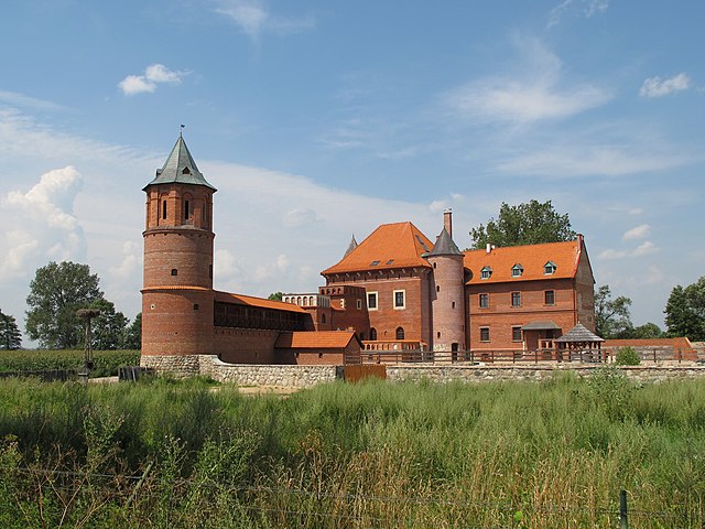
English: Castle built in 1433 by trakai and vilnus voivode Jan Gasztołd on place of old wooden fortress from 1st quarter of XIV century. Expanded in 1550-1582 by king Sigismund Augustus. Expansion was directed by military engineer and royal builder, Hiob Bretfus. After expansion one of the most powerful forts on lowland plains. Destroyed 1771/1914. Partially rebuilt in 2005.
Polski: Zamek zbudowany w 1433 roku przez wojewodę trockiego i wileńskiego Jana Gasztołda na miejscu drewnianej warowni z 1 ćw. XIV w. Rozbudowany w latach 1550-1582 przez króla Zygmunta Augusta. Rozbudową kierował inżynier wojskowy i budowniczy królewski, Hiob Bretfus. Po rozbudowie jedna z najpotężniejszych fortec wzniesionych na terenach nizinnych. Zniszczony w 1771/1914r. Częściowo odbudowany w 2005r. |
| Date | |
| Source | Own work |
| Author | Krzysztof Kundzicz |
| Other versions |
 |
| Camera location | | View this and other nearby images on: OpenStreetMap |
|---|
Licensing
I, the copyright holder of this work, hereby publish it under the following license:
This file is licensed under the Creative Commons Attribution-Share Alike 3.0 Unported license.
- You are free:
- to share – to copy, distribute and transmit the work
- to remix – to adapt the work
- Under the following conditions:
- attribution – You must give appropriate credit, provide a link to the license, and indicate if changes were made. You may do so in any reasonable manner, but not in any way that suggests the licensor endorses you or your use.
- share alike – If you remix, transform, or build upon the material, you must distribute your contributions under the same or compatible license as the original.
File history
Click on a date/time to view the file as it appeared at that time.
| Date/Time | Thumbnail | Dimensions | User | Comment | |
|---|---|---|---|---|---|
| current | 16:47, 10 October 2010 | | 3,227 × 2,420 (2.38 MB) | Athantor |
File usage
The following pages on the English Wikipedia use this file (pages on other projects are not listed):
Global file usage
The following other wikis use this file:
- Usage on cs.wikipedia.org
- Usage on de.wikivoyage.org
- Usage on lt.wikipedia.org
- Usage on pl.wikipedia.org
- Zamek w Tykocinie
- Wikiprojekt:Wiki Lubi Zabytki/wykazy/województwo podlaskie/powiat białostocki
- Wikiprojekt:Wiki Lubi Zabytki/wykazy/województwo podlaskie/powiat białostocki/Tykocin
- Wikipedia:Wiki Lubi Zabytki/podlaskie/powiat białostocki
- Wikipedia:Wiki Lubi Zabytki/podlaskie/powiat białostocki/gmina Tykocin
- Usage on uk.wikipedia.org
- Usage on vi.wikipedia.org
- Usage on www.wikidata.org