.jpg)
.jpg&action=edit&redlink=1)
No higher resolution available.
Pluto_map_(Hubble).jpg (350 × 208 pixels, file size: 11 KB, MIME type: image/jpeg)
| This is a file from the Wikimedia Commons. Information from its description page there is shown below. Commons is a freely licensed media file repository. You can help. |
.jpg)
| Description |
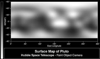
English: Map of direct images of Pluto from Hubble. These are among the higher-resolution images of Pluto's high southern latitudes, which were not imaged by New Horizons. |
| Date | |
| Source |
http://hubblesite.org/newscenter/archive/releases/1996/09/image/c/format/web/ https://hubblesite.org/contents/media/images/1996/09/401-Image.html |
| Author | Credits: Alan Stern (Southwest Research Institute), Marc Buie (Lowell Observatory), NASA and ESA |
Licensing
| This file is in the public domain in the United States because it was solely created by NASA. NASA copyright policy states that "NASA material is not protected by copyright unless noted". (See Template:PD-USGov, NASA copyright policy page or JPL Image Use Policy.) | ||
 |
Warnings:
|
File history
Click on a date/time to view the file as it appeared at that time.
| Date/Time | Thumbnail | Dimensions | User | Comment | |
|---|---|---|---|---|---|
| current | 00:05, 7 September 2008 | | 350 × 208 (11 KB) | Kwamikagami | higher res. is only pixilation |
| 23:52, 6 September 2008 |  | 703 × 434 (47 KB) | Kwamikagami | {{Information |Description=Map of direct images of Pluto from Hubble |Source=http://imgsrc.hubblesite.org/hu/db/1996/09/images/c/formats/print.jpg |Date=1996 |Author=Credits: Alan Stern (Southwest Research Institute), Marc Buie (Lowell Observatory), NASA |
File usage
No pages on the English Wikipedia use this file (pages on other projects are not listed).
.jpg)