
Size of this preview: 800 × 600 pixels. Other resolutions: 320 × 240 pixels | 640 × 480 pixels | 1,024 × 768 pixels | 1,280 × 960 pixels | 2,304 × 1,728 pixels.
Original file (2,304 × 1,728 pixels, file size: 278 KB, MIME type: image/jpeg)
| This is a file from the Wikimedia Commons. Information from its description page there is shown below. Commons is a freely licensed media file repository. You can help. |
Summary
| Description |
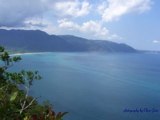
English: Pasaleng Bay, Ilocos Norte province. Northern terminus of the Cordillera Central range of Luzon, the Philippines |
| Date | |
| Source | Own work |
| Author | Gubernatoria |
| Permission (Reusing this file) |
acknowledge author |
| Camera location | | View this and other nearby images on: OpenStreetMap |
|---|
This file is licensed under the Creative Commons Attribution 2.5 Australia license.
- You are free:
- to share – to copy, distribute and transmit the work
- to remix – to adapt the work
- Under the following conditions:
- attribution – You must give appropriate credit, provide a link to the license, and indicate if changes were made. You may do so in any reasonable manner, but not in any way that suggests the licensor endorses you or your use.

File history
Click on a date/time to view the file as it appeared at that time.
| Date/Time | Thumbnail | Dimensions | User | Comment | |
|---|---|---|---|---|---|
| current | 11:18, 25 May 2009 | | 2,304 × 1,728 (278 KB) | Gubernatoria | {{Information |Description={{en|1=Pasaleng Bay, Ilocos Norte province. Northern terminus of the Cordillera Central range of Luzon, the Philippines}} |Source=Own work by uploader |Author=Gubernatoria |Date=2009-03-27 |Permission=ackno |
File usage
The following pages on the English Wikipedia use this file (pages on other projects are not listed):
Global file usage
The following other wikis use this file:
- Usage on ceb.wikipedia.org
- Usage on id.wikipedia.org
- Usage on ilo.wikipedia.org
- Usage on it.wikipedia.org
- Usage on www.wikidata.org