Original file (1,024 × 852 pixels, file size: 200 KB, MIME type: image/jpeg)
| This is a file from the Wikimedia Commons. Information from its description page there is shown below. Commons is a freely licensed media file repository. You can help. |

|
This map image could be re-created using vector graphics as an SVG file. This has several advantages; see Commons:Media for cleanup for more information. If an SVG form of this image is available, please upload it and afterwards replace this template with
{{vector version available|new image name}}.
It is recommended to name the SVG file “PLANO DE LA CIUDAD CHICLAYO Y SU AREA METROPOLITANA.svg”—then the template Vector version available (or Vva) does not need the new image name parameter. |


| Description |
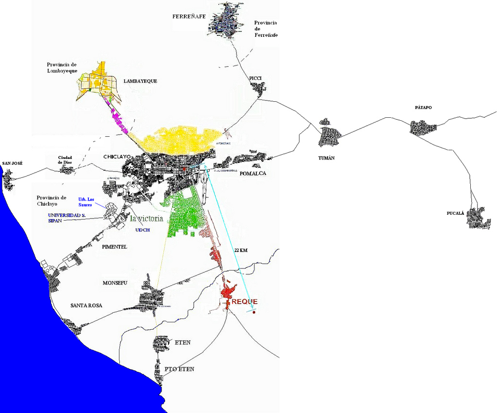
According to THE PROJECT DIRECTOR METROPOLITAN "CHICLAYO 2020" , will contemplate Chiclayo in future eight districts, which nowadays are the six of the central nucleus and two of the integrated discontinuous area of expansion of Chiclayo's city: 1.-The districts the City (Central Nucleus) at present: Chiclayo, Jose Leonardo Ortiz, The Victory, Pomalca, Pimentel, and Reque. Population urban = 546 054 Inhabitants. 2.-The districts , the Integrated discontinuous Area: San José (in Lambayeque) and Picsi. At present Chiclayo's city has a light trend and urban development projection of urban expansion to these two districts.All these districts were projected in form planned to 2020 for a future integration. 3.- Chiclayo a spatial urban area of has 30 km : Lambayeque, Ferreñafe, Monsefú , Picci, San José, Tumán, pucalá, Pátapo, Eten , Port Eten , Mochumi, Pítipo, Zaña, Cayaltí. Area metro population 910,255 Inhabitants |
||
| Date | |||
| Source | originally posted to Flickr as PLANO DE LA CIUDAD CHICLAYO Y SU AREA METROPOLITANA | ||
| Author | chiclayonortea | ||
| Permission (Reusing this file) |
This file is licensed under the Creative Commons Attribution-Share Alike 2.0 Generic license.
|
PLANO CIUDAD CHICLAYO, CITY CHICLAYO, VILLE CHICLAYO
File history
Click on a date/time to view the file as it appeared at that time.
| Date/Time | Thumbnail | Dimensions | User | Comment | |
|---|---|---|---|---|---|
| current | 16:39, 16 May 2008 | | 1,024 × 852 (200 KB) | Flickr upload bot | Uploaded from http://flickr.com/photo/11502309@N08/2460228077 using Flickr upload bot |
File usage
Global file usage
The following other wikis use this file:
- Usage on cs.wikipedia.org
- Usage on es.wikipedia.org
- Usage on fr.wikipedia.org
- Usage on it.wikipedia.org