File:Nova totius Terrarum Orbis geographica ac hydrographica tabula (Hendrik Hondius) balanced.jpg

Original file(5,248 × 3,688 pixels, file size: 5.3 MB, MIME type: image/jpeg)

Summary

Jodocus Hondius II: Nova totius terrarum orbis geographica ac hydrographica tabula  wikidata:Q120597485 reasonator:Q120597485
Artist
Jodocus Hondius II  (1593–1629)  wikidata:Q21016928
 
Description Dutch engraver, cartographer, editor, instrument maker, medical instrument maker and printmaker
Date of birth/death November 1593 Edit this at Wikidata August 1629 Edit this at Wikidata
Location of birth/death Amsterdam Amsterdam
Work location
Amsterdam (1612–1633) Edit this at Wikidata
Authority file
creator QS:P170,Q21016928
 Edit this at Wikidata
image of artwork listed in title parameter on this page
Author
Henricus Hondius II  (1597–1651)  wikidata:Q983261
 
Alternative names
Hendrick Hondius, Henricus Hondius II, Hendrik Hondius the Younger
Description Spanish-Dutch cartographer, publisher, printmaker, painter and bookseller
Date of birth/death 1597 Edit this at Wikidata 16 August 1651 Edit this at Wikidata
Location of birth/death Amsterdam Amsterdam
Work period 1612 Edit this at Wikidata–1644 Edit this at Wikidata
Work location
Authority file
creator QS:P170,Q983261
Title
Latin:
Nova Totius Terrarum Orbis Geographica ac Hydrographica Tabula

New Geographic and Hydrographic Map of the Whole World
title QS:P1476,la:"Nova Totius Terrarum Orbis Geographica ac Hydrographica Tabula"
label QS:Lla,"Nova Totius Terrarum Orbis Geographica ac Hydrographica Tabula"
label QS:Len,"New Geographic and Hydrographic Map of the Whole World"
Publisher
Object type world map / antique map / manuscript map / double hemisphere world map / early world maps Edit this at Wikidata
Genre map Edit this at Wikidata
Description

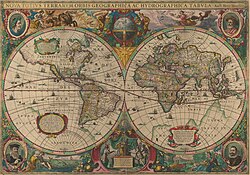
This is an image of Nova totius Terrarum Orbis geographica ac hydrographica tabula, a map of the world created by Hendrik Hondius in 1630, and published the following year in the atlas Atlantis Maioris Appendix.

Among its claims to notability is the fact that it was the first dated map published in an atlas, and therefore the first widely available map, to show any part of Australia, the only previous map to do so being Hessel Gerritsz' 1627 Caert van't Landt van d'Eendracht ("Chart of the Land of Eendracht"), which was not widely distributed.

The Australian coastline shown is part of the west coast of Cape York Peninsula, discovered by Jan Carstensz in 1623. Curiously, the map does not show the west coast features shown in Gerritsz' Caert.
Language Latin Edit this at Wikidata
Date The original map was executed in 1630, and published in 1631.
Publication date 1630 Edit this at Wikidata
Dimensions height: 54 cm (21.2 in) Edit this at Wikidata; width: 38 cm (14.9 in) Edit this at Wikidata
dimensions QS:P2048,+54U174728
dimensions QS:P2049,+38U174728
institution QS:P195,Q111677119
Place of publication unknown Edit this at Wikidata
Source/Photographer This is a scan of the copy belonging to the State Library of New South Wales. Access to it is available at http://image.sl.nsw.gov.au/cgi-bin/ebindshow.pl?doc=heritage/a1439;seq=13. The graphical user interface provided does not support downloading the full image at full resolution, but the back end can be cajoled to do so by manually editing the CGI arguments in the url, to http://image.sl.nsw.gov.au/cgi-bin/mrsid/image_jpeg.pl?client=heritage/a1439&image=a128994.sid&x=2624&y=1844&level=0&width=5248&height=3688.
Other versions This is a colour-balanced version; the original version is at Image:Nova totius Terrarum Orbis geographica ac hydrographica tabula (Hendrik Hondius).jpg

Licensing

This is a faithful photographic reproduction of a two-dimensional, public domain work of art. The work of art itself is in the public domain for the following reason:
Public domain

This work is in the public domain in its country of origin and other countries and areas where the copyright term is the author's life plus 100 years or fewer.


You must also include a United States public domain tag to indicate why this work is in the public domain in the United States.
The official position taken by the Wikimedia Foundation is that "faithful reproductions of two-dimensional public domain works of art are public domain".
This photographic reproduction is therefore also considered to be in the public domain in the United States. In other jurisdictions, re-use of this content may be restricted; see Reuse of PD-Art photographs for details.

Captions

Early Double Hemisphere World Map.

File history

Click on a date/time to view the file as it appeared at that time.

Date/TimeThumbnailDimensionsUserComment
current23:09, 6 February 2008Thumbnail for version as of 23:09, 6 February 20085,248 × 3,688 (5.3 MB)Hesperian{{Information |Description=This is an image of ''Nova totius Terrarum Orbis geographica ac hydrographica tabula'', a map of the world created by Hendrik Hondius in 1630, and published the following year in the atlas ''Atlantis Maioris Appendix
The following pages on the English Wikipedia use this file (pages on other projects are not listed):

Global file usage

The following other wikis use this file:

View more global usage of this file.

Metadata