
Size of this preview: 800 × 595 pixels. Other resolutions: 320 × 238 pixels | 640 × 476 pixels | 1,024 × 761 pixels | 1,280 × 951 pixels | 1,500 × 1,115 pixels.
Original file (1,500 × 1,115 pixels, file size: 660 KB, MIME type: image/png)
| This is a file from the Wikimedia Commons. Information from its description page there is shown below. Commons is a freely licensed media file repository. You can help. |
| Description |
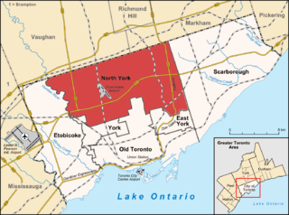
English: Map of Toronto Deutsch: Karte von Toronto |
| Date | (UTC) |
| Source | |
| Author |
|
| This is a retouched picture, which means that it has been digitally altered from its original version. Modifications: Highlight North York. The original can be viewed here: Toronto map.png:
|
I, the copyright holder of this work, hereby publish it under the following license:
This file is licensed under the Creative Commons Attribution-Share Alike 3.0 Unported license.
- You are free:
- to share – to copy, distribute and transmit the work
- to remix – to adapt the work
- Under the following conditions:
- attribution – You must give appropriate credit, provide a link to the license, and indicate if changes were made. You may do so in any reasonable manner, but not in any way that suggests the licensor endorses you or your use.
- share alike – If you remix, transform, or build upon the material, you must distribute your contributions under the same or compatible license as the original.
Original upload log
This image is a derivative work of the following images:
- File:Toronto_map.png licensed with Cc-by-sa-3.0
- 2009-06-29T15:18:26Z SimonP 1500x1115 (599277 Bytes) Corect East York border
- 2009-06-18T10:56:25Z Lencer 1500x1115 (693581 Bytes) + don valley parkway
- 2009-03-25T18:56:43Z Lencer 1500x1115 (688746 Bytes) Int. => Intl.
- 2009-03-18T12:19:50Z Lencer 1500x1115 (688623 Bytes) Vaugahn -> Vaughan
- 2009-03-10T06:54:51Z Lencer 1500x1115 (689526 Bytes) fix Greater Toronto Area
- 2009-03-09T12:29:31Z Lencer 1500x1115 (688152 Bytes) + Minimap, some fixes
- 2009-03-08T19:10:50Z Lencer 1500x1116 (643104 Bytes) weitere Kartenelemente erg., Farben geändert
- 2009-03-02T20:02:12Z Lencer 1500x1116 (485986 Bytes) Fehlerhafte Grenze bei York
- 2009-03-02T19:36:31Z Lencer 1500x1116 (504892 Bytes) {{Information| |Description= {{de|Karte von [[:de:Toronto|Toronto]]}} {{en|Map of [[:en:Toronto|Toronto]]}} |Source=own work, used: * OpenStreetMap * Google Earth * http://www.toronto.ca/demographics/profiles_map_and_index.
Uploaded with derivativeFX
File history
Click on a date/time to view the file as it appeared at that time.
| Date/Time | Thumbnail | Dimensions | User | Comment | |
|---|---|---|---|---|---|
| current | 14:42, 31 July 2009 | | 1,500 × 1,115 (660 KB) | SimonP | |
| 15:45, 29 June 2009 |  | 1,500 × 1,115 (578 KB) | SimonP | ||
| 15:38, 29 June 2009 |  | 1,500 × 1,115 (661 KB) | SimonP | {{Information |Description={{en|Map of Toronto}} {{de|Karte von Toronto}} |Source=*File:Toronto_map.png |Date=2009-06-29 16:38 (UTC) |Author=*File:Toronto_map.png: Lencer *derivative work: ~~~ |P |
File usage
The following pages on the English Wikipedia use this file (pages on other projects are not listed):
Global file usage
The following other wikis use this file:
- Usage on de.wikipedia.org
- Usage on es.wikipedia.org
- Usage on fa.wikipedia.org
- Usage on fi.wikipedia.org
- Usage on fr.wikipedia.org
- Usage on he.wikipedia.org
- Usage on it.wikipedia.org
- Usage on sr.wikipedia.org
- Usage on sv.wikipedia.org
- Usage on ta.wikipedia.org
- Usage on tr.wikipedia.org
- Usage on uk.wikipedia.org
- Usage on www.wikidata.org
- Usage on zh-yue.wikipedia.org