Size of this preview: 800 × 481 pixels. Other resolutions: 320 × 192 pixels | 640 × 385 pixels | 1,024 × 615 pixels | 1,280 × 769 pixels | 2,439 × 1,466 pixels.
Original file (2,439 × 1,466 pixels, file size: 1.16 MB, MIME type: image/png)
| This is a file from the Wikimedia Commons. Information from its description page there is shown below. Commons is a freely licensed media file repository. You can help. |
Summary
| Description |
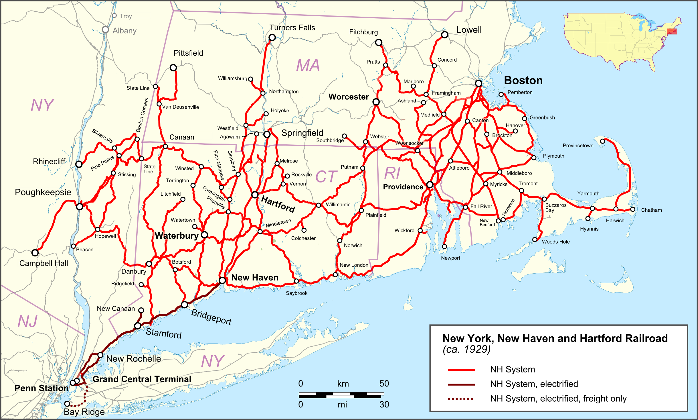
English: Map of New York, New Haven and Hartford Railroad Deutsch: Karte der New York, New Haven and Hartford Railroad |
| Date | |
| Source |
Map was created by using
|
| Author |
|
| Permission (Reusing this file) |
Map data (c) OpenStreetMap (and) contributors, CC-BY-SA |
Licensing
I, the copyright holder of this work, hereby publish it under the following license:
This file is licensed under the Creative Commons Attribution 3.0 Unported license.
- You are free:
- to share – to copy, distribute and transmit the work
- to remix – to adapt the work
- Under the following conditions:
- attribution – You must give appropriate credit, provide a link to the license, and indicate if changes were made. You may do so in any reasonable manner, but not in any way that suggests the licensor endorses you or your use.
| This work is licensed under the Open Database License (summary). |
File history
Click on a date/time to view the file as it appeared at that time.
| Date/Time | Thumbnail | Dimensions | User | Comment | |
|---|---|---|---|---|---|
| current | 21:04, 6 April 2017 | | 2,439 × 1,466 (1.16 MB) | Pechristener | spelling errors of some towns fixed |
| 15:55, 28 June 2016 |  | 2,439 × 1,466 (1.16 MB) | Pechristener | mehr Details | |
| 15:38, 28 June 2016 |  | 2,439 × 1,466 (1.16 MB) | Pechristener | kleines Detail | |
| 15:34, 28 June 2016 |  | 2,439 × 1,466 (1.16 MB) | Pechristener | == {{int:filedesc}} == {{Information |Description ={{en|1=Map of New York, New Haven and Hartford Railroad}}{{de|1=Karte der [[:de:New York, New Haven and Hartford Railroad|New York, New Haven and Ha... |
File usage
The following pages on the English Wikipedia use this file (pages on other projects are not listed):
Global file usage
The following other wikis use this file:
- Usage on de.wikipedia.org
- Usage on et.wikipedia.org