
Size of this PNG preview of this SVG file: 463 × 599 pixels. Other resolutions: 185 × 240 pixels | 371 × 480 pixels | 593 × 768 pixels | 791 × 1,024 pixels | 1,582 × 2,048 pixels | 765 × 990 pixels.
Original file (SVG file, nominally 765 × 990 pixels, file size: 11.56 MB)
| This is a file from the Wikimedia Commons. Information from its description page there is shown below. Commons is a freely licensed media file repository. You can help. |
Summary
| Description |
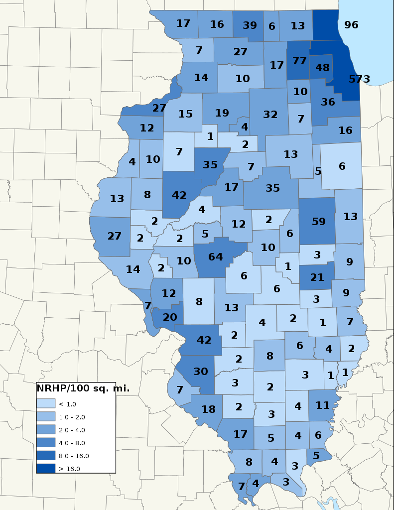
English: Map of Illinos NRHP/100 sq. mi., by county. As of 12/11/09
|
||
| Date | |||
| Source | Own work | ||
| Author | 25or6to4 |
Licensing
I, the copyright holder of this work, hereby publish it under the following licenses:
This file is licensed under the Creative Commons Attribution-Share Alike 3.0 Unported license.
- You are free:
- to share – to copy, distribute and transmit the work
- to remix – to adapt the work
- Under the following conditions:
- attribution – You must give appropriate credit, provide a link to the license, and indicate if changes were made. You may do so in any reasonable manner, but not in any way that suggests the licensor endorses you or your use.
- share alike – If you remix, transform, or build upon the material, you must distribute your contributions under the same or compatible license as the original.

|
Permission is granted to copy, distribute and/or modify this document under the terms of the GNU Free Documentation License, Version 1.2 or any later version published by the Free Software Foundation; with no Invariant Sections, no Front-Cover Texts, and no Back-Cover Texts. A copy of the license is included in the section entitled GNU Free Documentation License. |
You may select the license of your choice.
File history
Click on a date/time to view the file as it appeared at that time.
| Date/Time | Thumbnail | Dimensions | User | Comment | |
|---|---|---|---|---|---|
| current | 09:10, 10 April 2022 | | 765 × 990 (11.56 MB) | 25or6to4 | Updated through March 2022 |
| 06:20, 23 March 2019 |  | 765 × 990 (4.9 MB) | 25or6to4 | Updated through March 1, 2019 | |
| 17:21, 3 April 2016 |  | 612 × 792 (1.58 MB) | 25or6to4 | Updated through January 1, 2016 | |
| 07:22, 11 September 2014 |  | 612 × 792 (1.52 MB) | 25or6to4 | Updated through September 2014 | |
| 07:07, 16 September 2012 |  | 612 × 792 (437 KB) | 25or6to4 | updated through August 2012 | |
| 08:53, 17 December 2009 |  | 612 × 792 (401 KB) | 25or6to4 | {{Information |Description={{en|1=Map of Illinos NRHP/100 sq. mi., by county. As of 12/11/09}} |Source={{own}} |Author=25or6to4 |Date=12/11/09 |Permission= |other_versions= }} Category:Maps of Illinois [[Category:National Register o |
File usage
The following pages on the English Wikipedia use this file (pages on other projects are not listed):
Global file usage
The following other wikis use this file:
- Usage on de.wikipedia.org
- Usage on pt.wikipedia.org
- Usage on ro.wikipedia.org
- Chicago
- Illinois (dezambiguizare)
- Illinois
- Format:Illinois stat SUA
- Categorie:Statul Illinois, SUA
- Lake Forest, Illinois
- Ludwig Mies van der Rohe
- Springfield, Illinois
- Categorie:Formate Illinois
- Aurora, Illinois
- Joliet, Illinois
- Woodstock, Illinois
- Categorie:Comitate din statul Illinois, SUA
- Categorie:Liste Illinois
- Cairo, Illinois
- Lacul Michigan
- Peoria, Illinois
- Listă de oameni din statul Illinois
- Nauvoo, Illinois
- Categorie:Guvernul statului Illinois
- Listă de comitate din statul Illinois
- Categorie:Comitatul Kendall, Illinois
- Categorie:Comitatul Will, Illinois
- Categorie:Comitatul McHenry, Illinois
- Categorie:Comitatul Peoria, Illinois
- Categorie:Comitatul Sangamon, Illinois
- Maywood, Illinois
- Comitatul Alexander, Illinois
- Categorie:Comitatul Alexander, Illinois
- Comitatul Pope, Illinois
- Comitatul Pope, Minnesota
- Categorie:Comitatul Pope, Illinois
- Comitatul Will, Illinois
- Categorie:Sedii de comitate din Illinois
- Belleville, Illinois
- Comitatul Peoria, Illinois
- Categorie:Oameni din comitatul Winnebago, Illinois
- Categorie:Comitatul Winnebago, Illinois
- Comitatul McHenry, Illinois
- Categorie:Comitatul Adams, Illinois
- Categorie:Comitatul Bond, Illinois
- Categorie:Comitatul Boone, Illinois
- Categorie:Comitatul Brown, Illinois
- Categorie:Comitatul Bureau, Illinois
- Categorie:Comitatul Cass, Illinois
- Categorie:Comitatul Calhoun, Illinois
- Categorie:Comitatul Carroll, Illinois
- Categorie:Comitatul Champaign, Illinois
View more global usage of this file.