
Size of this preview: 800 × 533 pixels. Other resolutions: 320 × 213 pixels | 640 × 427 pixels | 1,024 × 683 pixels | 1,280 × 853 pixels | 2,560 × 1,707 pixels | 4,740 × 3,160 pixels.
Original file (4,740 × 3,160 pixels, file size: 7.14 MB, MIME type: image/jpeg)
| This is a file from the Wikimedia Commons. Information from its description page there is shown below. Commons is a freely licensed media file repository. You can help. |
Summary
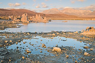
| Description | South Tufa, Mono Lake, California, USA. Mount Gibbs and Mount Dana in the backgrounds. |
| Date | Taken on 28 August 2013 |
| Source | Own work |
| Author | King of Hearts (talk · contribs) |
| Other versions |
| Camera location | | View this and other nearby images on: OpenStreetMap |
|---|
|
Licensing

|
Permission is granted to copy, distribute and/or modify this document under the terms of the GNU Free Documentation License, Version 1.2 or any later version published by the Free Software Foundation; with no Invariant Sections, no Front-Cover Texts, and no Back-Cover Texts. A copy of the license is included in the section entitled GNU Free Documentation License. |
This file is licensed under the Creative Commons Attribution-Share Alike 3.0 Unported license.
Attribution: King of Hearts / Wikimedia Commons / CC-BY-SA-3.0
- You are free:
- to share – to copy, distribute and transmit the work
- to remix – to adapt the work
- Under the following conditions:
- attribution – You must give appropriate credit, provide a link to the license, and indicate if changes were made. You may do so in any reasonable manner, but not in any way that suggests the licensor endorses you or your use.
- share alike – If you remix, transform, or build upon the material, you must distribute your contributions under the same or compatible license as the original.
File history
Click on a date/time to view the file as it appeared at that time.
| Date/Time | Thumbnail | Dimensions | User | Comment | |
|---|---|---|---|---|---|
| current | 00:12, 19 October 2013 | | 4,740 × 3,160 (7.14 MB) | King of Hearts | fix tilt |
| 23:51, 18 October 2013 |  | 4,928 × 3,264 (7.17 MB) | King of Hearts | VicuñaUploader 1.18 |
File usage
The following pages on the English Wikipedia use this file (pages on other projects are not listed):
Global file usage
The following other wikis use this file:
- Usage on de.wikipedia.org
- Usage on el.wikipedia.org
- Usage on en.wikivoyage.org
- Usage on es.wikipedia.org
- Usage on id.wikipedia.org
- Usage on it.wikipedia.org
- Usage on la.wikipedia.org
- Usage on sr.wikipedia.org
- Usage on tr.wikipedia.org
- Usage on vi.wikipedia.org
- Usage on www.wikidata.org