
Size of this preview: 450 × 600 pixels. Other resolutions: 180 × 240 pixels | 360 × 480 pixels | 576 × 768 pixels | 768 × 1,024 pixels | 1,536 × 2,048 pixels | 3,000 × 4,000 pixels.
Original file (3,000 × 4,000 pixels, file size: 2.63 MB, MIME type: image/jpeg)
| This is a file from the Wikimedia Commons. Information from its description page there is shown below. Commons is a freely licensed media file repository. You can help. |
Summary
| Camera location | | View this and other nearby images on: OpenStreetMap |
|---|
| Description |
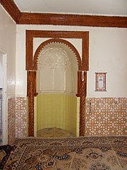
Français : Le mihrab est le seul vestige restant de la mosquée fondée par Ibn Toumert à Oued Ghir en Algérie, qui aurait été construite entre 1117 et 1120, selon certains récits. On raconte également que c'est dans cette mosquée que s'est déroulée la rencontre historique entre Ibn Toumert et Abdelmoumen, le fondateur de la dynastie Almohade. Malheureusement, la mosquée elle-même a complètement disparu, et une autre mosquée a été érigée à sa place. En reconnaissance de son importance culturelle, le mihrab a été classé comme patrimoine national le 3 novembre 1999.
English: The mihrab is the only remaining vestige of the mosque founded by Ibn Toumert in Oued Ghir, Algeria, which is believed to have been built between 1117 and 1120, according to some accounts. It is also said that it was in this mosque that the historic meeting between Ibn Toumert and Abdelmoumen, the founder of the Almohad dynasty, took place. Unfortunately, the mosque itself has completely disappeared, and another mosque has been erected in its place. Recognizing its cultural significance, the mihrab was classified as a national heritage site on November 3, 1999. |
| Date | |
| Source | Own work |
| Author | Indif |
Licensing
I, the copyright holder of this work, hereby publish it under the following license:
This file is licensed under the Creative Commons Attribution-Share Alike 3.0 Unported license.
- You are free:
- to share – to copy, distribute and transmit the work
- to remix – to adapt the work
- Under the following conditions:
- attribution – You must give appropriate credit, provide a link to the license, and indicate if changes were made. You may do so in any reasonable manner, but not in any way that suggests the licensor endorses you or your use.
- share alike – If you remix, transform, or build upon the material, you must distribute your contributions under the same or compatible license as the original.

|
This image was uploaded as part of Wiki Loves Monuments 2013.
|
 |
File history
Click on a date/time to view the file as it appeared at that time.
| Date/Time | Thumbnail | Dimensions | User | Comment | |
|---|---|---|---|---|---|
| current | 20:42, 16 May 2012 | | 3,000 × 4,000 (2.63 MB) | Rotatebot | Bot: Image rotated by 90° |
| 05:21, 12 May 2012 |  | 4,000 × 3,000 (2.7 MB) | Indif |
File usage
The following pages on the English Wikipedia use this file (pages on other projects are not listed):
Global file usage
The following other wikis use this file:
- Usage on ar.wikipedia.org
- Usage on fr.wikipedia.org